姜筱巍, 吴一全( )
)
收稿日期:2025-01-13
修回日期:2025-03-26
接受日期:2025-04-28
出版日期:2025-05-12
发布日期:2025-05-08
通讯作者:
吴一全
E-mail:nuaaimage@163.com
基金资助:
Xiaowei JIANG, Yiquan WU()
Received:2025-01-13
Revised:2025-03-26
Accepted:2025-04-28
Online:2025-05-12
Published:2025-05-08
Contact:
Yiquan WU
E-mail:nuaaimage@163.com
Supported by:摘要:
无人机因其轻便灵活、拍摄覆盖面广、成本较低等优势,在军事侦察、农业监测、城市规划与管理等领域发挥了重大作用。在这些应用中,无人机航拍因视野受限,无法得到完整目标区域的高清全景图像,因此图像拼接技术必不可少。近年来,深度学习的发展使得无人机航拍图像拼接技术再度受到关注。综述了近10年来无人机航拍图像拼接方法的研究进展。首先简介无人机航拍图像拼接方法的发展历程及主要流程。然后按图像预处理、图像配准、图像融合3大步骤详细说明无人机航拍图像拼接的传统方法,并对比每个步骤所采用方法的优缺点。接着阐述了基于深度学习的无人机航拍图像拼接方法,从基于深度学习的语义分割、图像配准、图像拼接框架这3个方面进行详细说明。随后梳理了常见无人机航拍图像拼接数据集与图像拼接性能评价指标,并列举了5项无人机航拍图像拼接技术的典型应用领域。最后指出无人机航拍图像拼接仍面临着多项技术挑战,并对未来工作进行了展望。
中图分类号:
姜筱巍, 吴一全. 无人机航拍图像拼接方法研究进展[J]. 航空学报, 2025, 46(17): 331799.
Xiaowei JIANG, Yiquan WU. Research progress of UAV aerial image mosaic methods[J]. Acta Aeronautica et Astronautica Sinica, 2025, 46(17): 331799.
表1
无人机航拍图像拼接技术发展历程
| 阶段 | 起止年份 | 主要方法 | 优势 | 局限性 |
|---|---|---|---|---|
| 第1阶段 | 1996—2015 | SIFT、SURF、APAP等 | 拼接速度快、鲁棒性强 | 无法应对低特征和复杂场景 |
| 第2阶段 | 2015至今 | 结合POS数据、无监督网络等 | 应对复杂场景、泛化能力强 | 需要大量数据进行训练 |
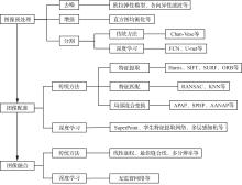
图 1
无人机图像拼接流程图

表2
图像预处理方法对比
| 文献 | 目的 | 具体方法 | 优势 | 局限性 | 性能指标 |
|---|---|---|---|---|---|
| [ | 去噪 | 欧拉弹性模型 | 实现含噪无人机航拍图像拼接 | 仅对模拟含噪图像进行实验分析 | CMR:88.9% PSNR:31.32 dB 时间:45.49 s |
| [ | 去噪、增强 | 各向异性滤波、直方图均衡化 | 提高拼接效率和精度 | 未验证算法鲁棒性 | 主观评价 |
| [ | 分割 | 形态学改进CV分割 | 实现精确分割,便于后续特征提取 | 运行效率和可移植性有待改进 | RMSE:29.58 时间:12.23 s |
表3
Harris算法相关拼接方法对比
| 文献 | 具体方法 | 优势 | 局限性 | 性能指标 |
|---|---|---|---|---|
| [ | 改进Harris | 提升拼接准确性 减少拼接时间 | 未说明算法在不同光照条件下的表现 | 时间:3.56 s CMR:80.9% |
| [ | 改进Harris | 提高拼接速度、鲁棒性和自适应程度 | 未验证算法在实际复杂场景中的性能表现 | CMR:96.85% 匹配时间:7.98 s |
| [ | Harris结合SURF | 提高图像匹配效率和准确性 | 未提及算法对噪声和复杂场景的鲁棒性 | 匹配时间:0.98 s |
| [ | Harris结合自适应NMS | 减少特征检测时间 提升拼接速度 | 未讨论算法在大规模图像数据上的应用效率 | 时间:81.5 s |
表4
SIFT算法相关拼接方法对比
| 文献 | 具体方法 | 优势 | 局限性 | 性能指标 |
|---|---|---|---|---|
| [ | GA-SIFT算法 | 减少了拼接时间 提高了匹配精度 | 对于高动态变化环境的适应性未进行深入探讨 | 匹配时间:12.21 s |
| [ | 分块SIFT | 提高匹配效率 有效消除接缝 | 未评估拼接图像质量 | 时间:11.17 s |
| [ | CUDA-SIFT | 实现实时高效拼接 | 算法性能会受到光照条件或图像质量影响 | SSIM:96.84% PSNR:35.95 dB 时间:62 s |
| [ | SIFT结合球面投影 | 解决全景图像定位和测量问题 | 未考虑算法在不同地形和光照条件下的鲁棒性 | 未采用常见性能指标 |
| [ | SIFT结合POS数据 | 提高拼接实时性和质量 | 未讨论算法在复杂环境下的准确性和鲁棒性 | PSNR:10.152 2 dB |
表5
SURF算法相关拼接方法对比
| 文献 | 具体方法 | 优势 | 局限性 | 性能指标 |
|---|---|---|---|---|
| [ | 改进SURF | 较高的匹配率、准确性和鲁棒性 | 较高的计算复杂性和资源消耗 | 时间:1.34 s CMR:99.9% RMSE:0.648 |
| [ | SURF结合球形变换 | 提高了实时性和鲁棒性 | 处理具有大视差或高动态范围图像时存在局限性 | 时间:1.72 s |
| [ | IB-SURF | 提高了匹配率和正确率 | 处理小色差、非规则形状或高动态范围的图像时效果不佳 | 提取时间:1.68 s 匹配时间:0.41 s |
| [ | SURF结合倒二叉树 | 显著提高拼接速度 | 依赖硬件性能 | 时间:167.93 s |
| [ | SURF结合K-d树 | 减少处理时间 实现自动实时拼接 | 只能处理等高度飞行条件下拍摄的图片 | 配准时间:1.1 ms |
| [ | SURF | 利用图像拼接实现无人机定位 | 在图像特征点较少或质量较差情况下效果受限 | 主观评价 |
表6
ORB算法相关拼接方法对比
| 文献 | 具体方法 | 优势 | 局限性 | 性能指标 |
|---|---|---|---|---|
| [ | ORB | 较高的准确性和效率 | 处理大规模或高动态范围图像时效果有限 | 时间:0.108 s |
| [ | ORB结合PCA | 显著提升速度和准确性 | 需要相应的GPU硬件支持 | 时间:2.72 s RMSE:0.48 |
| [ | 改进ORB | 提高拼接速度和精度 | 受地理信息精度影响 | 时间:0.68 s |
| [ | 改进ORB | 具有稳健性和尺度不变性 | 算法效率有待提升 | 特征提取时间:0.510 ms CMR:96.485% 匹配时间:0.608 1 s RMSE:0.561 |
| [ | 改进ORB | 提高拼接精度和效率 | 实时性有待提升 | CMR:90.295% 时间:2.87 s |
表7
RANSAC算法相关拼接方法对比
| 文献 | 具体方法 | 优势 | 局限性 | 性能指标 |
|---|---|---|---|---|
| [ | 改进RANSAC | 减小反向投影错误率 提高拼接速度 | 多图拼接性能有待验证 | 时间:99.76 s |
| [ | 改进RANSAC | 提高算法执行速度 | 未对拼接质量进行评价 | 时间:0.61 s |
| [ | PSSC-RANSAC | 专门针对航拍图像配准 | 不适用于多视图几何问题 | 匹配时间:5.25 s |
表8
KNN算法相关拼接方法对比
| 文献 | 具体方法 | 优势 | 局限性 | 性能指标 |
|---|---|---|---|---|
| [ | 改进KNN | 提高匹配速度 | 受图片地理位置信息精度限制 | PSNR:3.206 dB |
| [ | Grid-KNN | 提高匹配速度 | 特征提取速度有所下降 | 时间:2.463 s CMR:95.17% |
表9
APAP算法相关拼接方法对比
| 文献 | 具体方法 | 优势 | 局限性 | 性能指标 |
|---|---|---|---|---|
| [ | APAP结合SIFT | 减少影像重影和透视失真 | 未讨论算法在处理动态场景或实时数据时的性能 | 未采用常见性能指标 |
| [ | APAP结合线段矫正 | 保护图像中独特的线段结构 | 未讨论对复杂地形的适应性 | mRMSE:1.07 |
| [ | APAP结合直线特征约束 | 减少重叠区域鬼影和非重叠区域失真 | 算法效率随图像中直线结构增加而降低 | 时间:33.23 s |
| [ | APAP结合AKAZE | 视差环境下效果良好 | 未进行不同飞行条件下的适应性分析 | PSNR:14.40 dB SSIM:32.54% RMSE:1.56 |
表10
SPHP算法相关拼接方法对比
| 文献 | 具体方法 | 优势 | 局限性 | 性能指标 |
|---|---|---|---|---|
| [ | 改进SPHP | 提高配准精度 解决非重叠区域变形失真问题 | 未讨论处理大规模图像时的性能 | RMSE:4.271 |
| [ | SPHP | 拼接视觉效果良好 | 非静态场景下可能出现伪影 | 未采用常见性能指标 |
| [ | SPHP | 减少拼接重影和变形 | 未提及处理非均匀光照精和复杂纹理时的性能 | CMR:4.065% 匹配时间:8.122 s |
表11
AANAP算法相关拼接方法对比
| 文献 | 具体方法 | 优势 | 局限性 | 性能指标 |
|---|---|---|---|---|
| [ | AANAP结合RSIFT | 提高特征提取速度和准确性 改善拼接图像视觉效果 | 未讨论复杂场景下的效果 | IE:6.397 8 SD:80.281 8 |
| [ | AANAP结合Quick-SIFT | 提高特征提取速度 改善幽影效应 | 未提及算法的可扩展性 | IE:6.479 9 SD:80.380 9 |
表12
线性加权融合方法对比
| 文献 | 具体方法 | 优势 | 局限性 | 性能指标 |
|---|---|---|---|---|
| [ | 线性加权融合 | 抑制拼接模糊、严重畸形,消除重影错位 | 鲁棒性和可移植性有待验证 | IE:6.397 2 SD:80.290 9 时间:5.71 s |
| [ | 加权平均融合 | 消除光照、仪器等产生的拼接线问题 | 拼接耗时较长 | 未采用常见性能指标 |
表13
最佳缝合线融合方法对比
| 文献 | 具体方法 | 优势 | 局限性 | 性能指标 |
|---|---|---|---|---|
| [ | QEB-U | 减少大视差图像拼接中的错位和伪影问题 | 面对高分辨率图像时存在挑战 | 时间:200 s EG:0.572 |
| [ | 超像素无缝拼接 | 提高拼接效率 实现颜色自然过渡 | 细节处理存在局限 | PSNR:42.14 dB |
表14
多分辨率融合方法对比
| 文献 | 具体方法 | 优势 | 局限性 | 性能指标 |
|---|---|---|---|---|
| [ | 改进多分辨率融合 | 提升拼接效果 实现无缝拼接 | 在多载荷无人机影像上性能受限 | SSIM:99.7% PSNR:42.457 dB 时间:6.165 s |
| [ | 多分辨率融合 | 减少鬼影、虚影和累计误差 | 算法泛化能力需进一步验证 | IE:6.79 AG:7.73 时间:620.42 s |

图 2
FCN图像分割处理流程图[105]
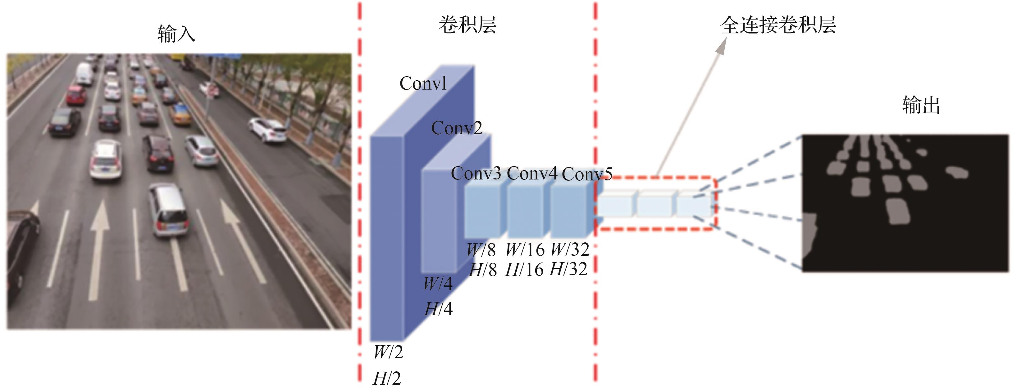
表15
基于深度学习的语义分割技术对比
| 文献 | 具体方法 | 优势 | 局限性 | 性能指标 |
|---|---|---|---|---|
| [ | FCN网络 | 解决拼接错位和撕裂问题 | 复杂环境下性能受限 | IE:7.203 AG:12.353 1 PSNR:14.098 dB RMSE:49.967 4 |
| [ | U-net | 更好地提取叶片边缘信息 | 需要大量数据支撑 | RMSE:4.44 成功率:97.8% |
| [ | U-net | 处理多视角大视差下的图像 | 复杂场景下性能有待提升 | 成功率:91% |
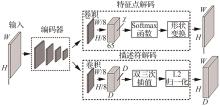
图 3
SuperPoint网络结构
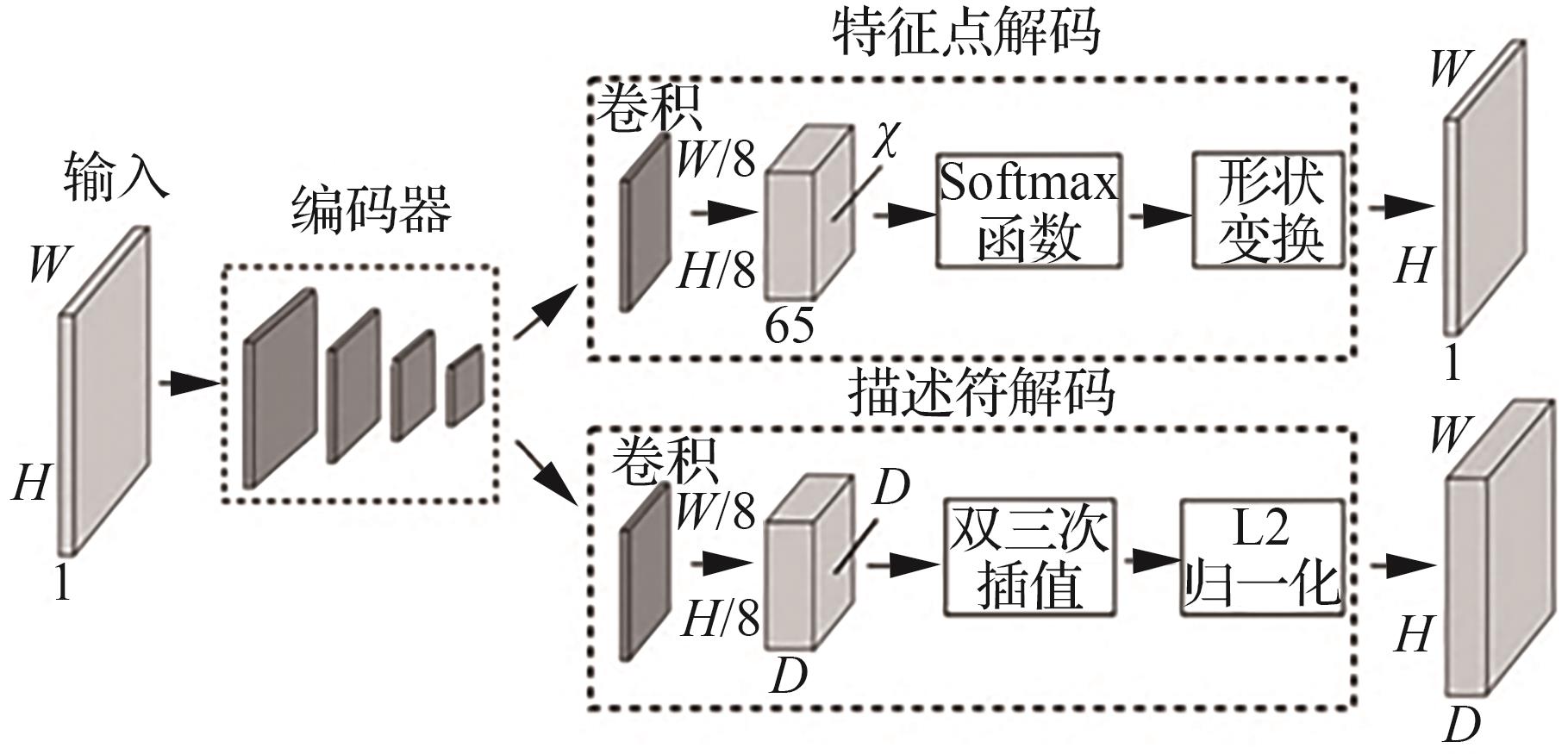
表16
基于深度学习的图像配准技术对比
| 文献 | 具体方法 | 优势 | 局限性 | 性能指标 |
|---|---|---|---|---|
| [ | SuperPoint网络结合矩阵迭代算法 | 显著提高拼接速度和精度 | 仅适用于公路环境 | CMR:71% IE:7.45 |
| [ | SuperPoint、SuperGlue | 实现高光谱图像拼接 | 对同质区域的光谱矫正不够精确 | SSIM:95.18% 时间:98.56 s |
| [ | 孪生特征提取网络 | 实现弱纹理图像的特征提取 | 对大视差图像的效果有待验证 | SSIM:75.3% RMSE:0.538 |
| [ | MLP | 平衡拼接速度和精度 | 依赖于高精度的位置和姿态信息 | 配准时间:12.37 ms |
| [ | ResNet-50 | 无需额外训练 不依赖图像特征 | 环境变化情况下的性能有待验证 | RMSE:0.973 5 时间:179.928 9 s |
| [ | CNN | 提高结构相似性指数和边缘差异谱指数 | 复杂场景下的性能需进一步提升 | 未采用常见性能指标 |
表17
基于深度学习的图像拼接框架对比
| 文献 | 具体方法 | 优势 | 局限性 | 性能指标 |
|---|---|---|---|---|
| [ | 无监督网络 | 实现更好的视觉拼接效果和鲁棒性 | 计算量大,硬件性能要求高 | PSNR:27.251 3 dB SSIM:83.77% RMSE:3.013 6 时间:3.63 s |
| [ | IMDQN | 降低误差累积 | 图像模糊和失真情况下性能受限 | RMSE:0.398 8 |
表18
公共无人机航拍数据集
| 名称 | 图像总数 | 图像大小 | 内容 |
|---|---|---|---|
| DOTA | 2 806 | 800×800~4 000×4 000 | 来自大型飞机、无人机的遥感图像,包含15个类别的物体,包括飞机,轮船,储罐,棒球场等 |
| VEDIA | 1 210 | 512×512,1 024×1 024 | 包含9个类别,主要包括飞机、汽车、卡车等 |
| NWPU | 31 500 | 256×256 | 涵盖45个场景类别,包括机场、海滩、森林等 |
| DIOR | 23 463 | 800×800 | 不同天气、不同季节下多个类别的航拍图像,包括飞机、机场、桥梁等 |
| UAV-VisLoc | 6 742 | 未提及 | 包含多种地貌特征、多高度多角度的无人机图像 |
表19
自建无人机航拍数据集
| 文献 | 图像总数 | 图像大小 | 内容 |
|---|---|---|---|
| [ | 92 | 4 000×3 000 | 包括湖面、河道和沿湖村庄 |
| [ | 275 | 3 000×4 000 | 包含湖边、喷泉、小区、公路和公园5个地面场景 |
| [ | 116 | 6 000×4 000 | 采用无人机携带20 mm焦距镜头对台湾台东县柳榆山进行航拍得到 |
| [ | 37 | 1 210×902 | 黑龙江省某农田环境 |
| [ | 635 | 未提及 | 包括森林、山川、农田、水域、城市建设和道路信息图像 |
| [ | 23 | 5 456×3 632 | 单面风机叶片图像 |
| [ | 104 | 5 478×3 648 | 每张图像都带有GPS、IMU等信息,目标景观包括但不限于草地、道路、水面等 |
| [ | 500 | 未提及 | 包括山地、水域、建筑等多种目标 |
| [ | 300 | 7 952×5 304 | 某水稻研究院及其周边地区的农田环境 |
| [ | 500 | 2 688×1 512 | 具有代表性的路面裂纹图像 |
表20
常用客观评价指标
| 指标 | 含义 | 公式 |
|---|---|---|
| 信息熵( | 衡量图像的信息含量 | |
| 平均梯度( | 评估图像边缘和纹理的清晰程度 | |
| 标准差( | 评估图像的对比度以及图像内部的像素差异度 | |
| 能量梯度( | 反映图像中像素或区域之间的差异程度 | |
| 均方根误差( | 衡量接缝处顺滑程度 |
表21
常用差异性指标
| 指标 | 含义 | 公式 |
|---|---|---|
| 匹配正确率( | 衡量匹配正确程度 | |
| 峰值信噪比( | 用于量化两图像之间的差异 | |
| 结构相似性指数( | 评价两图像像素和结构之间的差异 |
表22
无人机航拍图像拼接技术应用汇总
| 应用领域 | 具体说明 |
|---|---|
| 军事侦察 | 利用无人机航拍图像拼接技术得到的战场全景图像可以帮助指挥人员了解战场动态,获取敌方情报,做出战略决策 |
| 农业信息检测 | 将无人机航拍得到的多张农田图像借助图像拼接技术整合成农田全景视图,助力精准农业管理和农情信息分析 |
| 城市规划与管理 | 无人机航拍图像拼接技术在城市规划中可于空间布局规划、环境监测与保护,提供城市空间的高精度测绘和实时数据支持 |
| 灾害救援与环境监测 | 无人机航拍图像拼接技术可用于获取灾情现场的详细信息,实现快速评估灾情,监测环境状况,为救援团队提供关键信息 |
| 设备巡检 | 借助无人机航拍图像拼接技术可以快速设检测基础设施的损坏情况,提高巡检效率和安全性 |
| [1] | 江波, 屈若锟, 李彦冬, 等. 基于深度学习的无人机航拍目标检测研究综述[J]. 航空学报, 2021, 42(4): 524519. |
| JIANG B, QU R K, LI Y D, et al. Object detection in UAV imagery based on deep learning: Review[J]. Acta Aeronautica et Astronautica Sinica, 2021, 42(4): 524519 (in Chinese). | |
| [2] | 李岩山, 裴继红, 谢维信, 等. 一种新的无人机航拍序列图像快速拼接方法[J]. 电子学报, 2012, 40(5): 935-940. |
| LI Y S, PEI J H, XIE W X, et al. A new fast automatic mosaic method on unmanned aerial vehicle images[J]. Acta Electronica Sinica, 2012, 40(5): 935-940 (in Chinese). | |
| [3] | BOUGUETTAYA A, ZARZOUR H, KECHIDA A, et al. Deep learning techniques to classify agricultural crops through UAV imagery: A review[J]. Neural Computing & Applications, 2022, 34(12): 9511-9536. |
| [4] | 谭翔, 毛海颖, 支晓栋, 等. 基于无人机红外光谱技术的影像数据匹配方法研究[J]. 光谱学与光谱分析, 2018, 38(2): 413-417. |
| TAN X, MAO H Y, ZHI X D, et al. Research on image data matching method based on infrared spectrum technology of UAV[J]. Spectroscopy and Spectral Analysis, 2018, 38(2): 413-417 (in Chinese). | |
| [5] | 吴俣, 余涛, 谢东海. 面向应急响应的无人机图像快速自动拼接[J]. 计算机辅助设计与图形学学报, 2013, 25(3): 410-416. |
| WU Y, YU T, XIE D H. Fast automatic stitching for images of unmanned aerial vehicle in emergency response[J]. Journal of Computer-Aided Design & Computer Graphics, 2013, 25(3): 410-416 (in Chinese). | |
| [6] | 余淮, 杨文. 一种无人机航拍影像快速特征提取与匹配算法[J]. 电子与信息学报, 2016, 38(3): 509-516. |
| YU H, YANG W. A fast feature extraction and matching algorithm for unmanned aerial vehicle images[J]. Journal of Electronics & Information Technology, 2016, 38(3): 509-516 (in Chinese). | |
| [7] | 曹世翔, 江洁, 张广军, 等. 边缘特征点的多分辨率图像拼接[J]. 计算机研究与发展, 2011, 48(9): 1788-1793. |
| CAO S X, JIANG J, ZHANG G J, et al. Multi-scale image mosaic using features from edge[J]. Journal of Computer Research and Development, 2011, 48(9): 1788-1793 (in Chinese). | |
| [8] | LI J, WANG Z M, LAI S M, et al. Parallax-tolerant image stitching based on robust elastic warping[J]. IEEE Transactions on Multimedia, 2018, 20(7): 1672-1687. |
| [9] | 杨佳宾, 姜永涛, 杨幸彬, 等. 基于Dense SIFT特征的无人机影像快速拼接方法[J]. 地球信息科学学报, 2019, 21(4): 588-599. |
| YANG J B, JIANG Y T, YANG X B, et al. A fast mosaic algorithm of UAV images based on dense SIFT feature matching[J]. Journal of Geo-Information Science, 2019, 21(4): 588-599 (in Chinese). | |
| [10] | 郭璠, 李小虎, 刘文韬, 等. 基于参数回归的快速全景图像拼接算法[J]. 通信学报, 2023, 44(9): 36-47. |
| GUO F, LI X H, LIU W T, et al. Fast panoramic image stitching algorithm based on parameter regression[J]. Journal on Communications, 2023, 44(9): 36-47 (in Chinese). | |
| [11] | 张玲, 穆文鹏, 陈北京. 面向图像拼接检测的自适应残差算法[J]. 中国图象图形学报, 2024, 29(2): 419-429. |
| ZHANG L, MU W P, CHEN B J. Adaptive residual algorithm for image splicing detection[J]. Journal of Image and Graphics, 2024, 29(2): 419-429 (in Chinese). | |
| [12] | DONG C, LOY C C, HE K M, et al. Learning a deep convolutional network for image super-resolution[C]∥Computer Vision-ECCV 2014. Cham: Springer International Publishing, 2014: 184-199. |
| [13] | LIU Z, LIN Y T, CAO Y, et al. Swin transformer: hierarchical vision transformer using shifted windows[C]∥2021 IEEE/CVF International Conference on Computer Vision (ICCV). Piscataway: IEEE Press, 2021: 9992-10002. |
| [14] | 吴付杰, 王博文, 齐静雅, 等. 机载多孔径全景图像合成技术研究进展[J]. 航空学报, 2025, 46(3): 630505. |
| WU F J, WANG B W, QI J Y, et al. A review of airborne multi-aperture panoramic image compositing[J]. Acta Aeronautica et Astronautica Sinica, 2025, 46(3): 630505 (in Chinese). | |
| [15] | 杨利春, 田彬, 党建武. 基于深度学习的图像拼接算法研究综述[J]. 计算机应用研究, 2024, 41(7): 1930-1939. |
| YANG L C, TIAN B, DANG J W. Survey on image stitching algorithm based on deep learning[J]. Application Research of Computers, 2024, 41(7): 1930-1939 (in Chinese). | |
| [16] | 潘维东, 李安虎, 刘兴盛. 基于区域优化的图像拼接技术研究及应用进展[J]. 激光与光电子学进展, 2024, 61(18): 1800004. |
| PAN W D, LI A H, LIU X S. Progress in research and application of image stitching technology based on regional optimization[J]. Laser & Optoelectronics Progress, 2024, 61(18): 1800004 (in Chinese). | |
| [17] | FU M Y, LIANG H, ZHU C H, et al. Image stitching techniques applied to plane or 3-D models: A review[J]. IEEE Sensors Journal, 2023, 23(8): 8060-8079. |
| [18] | JAGADEESWARI M, MANIKANDABABU C S, SREE DHVIYA M, et al. Review: A comparative study based on video stitching methods[C]∥2021 Second International Conference on Electronics and Sustainable Communication Systems (ICESC). Piscataway: IEEE Press, 2021: 1157-1163. |
| [19] | 狄颖辰, 陈云坪, 陈莹莹, 等. 无人机图像拼接算法综述[J]. 计算机应用, 2011, 31(1): 170-174. |
| DI Y C, CHEN Y P, CHEN Y Y, et al. Survey on image mosaic algorithm of unmanned aerial vehicle[J]. Journal of Computer Applications, 2011, 31(1): 170-174 (in Chinese). | |
| [20] | MERJULAH R, CHANDRA J. Medical image classification using MRI: An investigation[M]∥Proceedings of the International Conference on ISMAC in Computational Vision and Bio-Engineering 2018 (ISMAC-CVB). Cham: Springer International Publishing, 2019: 1135-1146. |
| [21] | GÓMEZ-REYES J K, BENÍTEZ-RANGEL J P, MORALES-HERNÁNDEZ L A, et al. Image mosaicing applied on UAVs survey[J]. Applied Sciences, 2022, 12(5): 2729. |
| [22] | LOWE D G. Distinctive image features from scale-invariant keypoints[J]. International Journal of Computer Vision, 2004, 60(2): 91-110. |
| [23] | BAY H, TUYTELAARS T, VAN GOOL L. SURF: Speeded up robust features[M]∥Computer Vision-ECCV 2006. Berlin: Springer, 2006: 404-417. |
| [24] | RUBLEE E, RABAUD V, KONOLIGE K, et al. ORB: An efficient alternative to SIFT or SURF[C]∥2011 International Conference on Computer Vision. Piscataway: IEEE Press, 2011: 2564-2571. |
| [25] | ZARAGOZA J, CHIN T J, BROWN M S, et al. As-projective-as-possible image stitching with moving DLT[C]∥2013 IEEE Conference on Computer Vision and Pattern Recognition. Piscataway: IEEE Press, 2013: 2339-2346. |
| [26] | LIN C C, PANKANTI S U, RAMAMURTHY K N, et al. Adaptive as-natural-as-possible image stitching[C]∥2015 IEEE Conference on Computer Vision and Pattern Recognition (CVPR). Piscataway: IEEE Press, 2015: 1155-1163. |
| [27] | 王斌, 王伟锋. 一种基于局部灰度匹配的无人机图像拼接算法[J]. 中国石油大学学报(自然科学版), 2009, 33(2): 169-173. |
| WANG B, WANG W F. Unmanned aerial vehicle image mosaic algorithm based on local gray fitting[J]. Journal of China University of Petroleum (Edition of Natural Science), 2009, 33(2): 169-173 (in Chinese). | |
| [28] | 曹健, 李侃, 高春晓, 等. 局部特征在航拍图像拼接中的应用[J]. 电子科技大学学报, 2013, 42(1): 125-129. |
| CAO J, LI K, GAO C X, et al. Application of local features in aerial image mosaic[J]. Journal of University of Electronic Science and Technology of China, 2013, 42(1): 125-129 (in Chinese). | |
| [29] | 徐玉华, 龚文全, 苏昂, 等. 近似平面场景多视点图像拼接算法[J]. 国防科技大学学报, 2014, 36(2): 148-155. |
| XU Y H, GONG W Q, SU A, et al. Multi-viewpoint image mosaicing algorithm for roughly planar scenes[J]. Journal of National University of Defense Technology, 2014, 36(2): 148-155 (in Chinese). | |
| [30] | 程争刚, 张利. 一种基于无人机位姿信息的航拍图像拼接方法[J]. 测绘学报, 2016, 45(6): 698-705. |
| CHENG Z G, ZHANG L. An aerial image mosaic method based on UAV position and attitude information[J]. Acta Geodaetica et Cartographica Sinica, 2016, 45(6): 698-705 (in Chinese). | |
| [31] | 赵丽颖, 付强, 黄丹飞, 等. 基于无人机航拍图像快速拼接方法的研究[J]. 长春理工大学学报(自然科学版), 2021, 44(6): 39-46. |
| ZHAO L Y, FU Q, HUANG D F, et al. Research on fast mosaic method of UAV aerial image[J]. Journal of Changchun University of Science and Technology (Natural Science Edition), 2021, 44(6): 39-46 (in Chinese). | |
| [32] | 冯向东, 魏春英. 基于覆盖区域自适应优化的无人机航拍拼接方法[J]. 无线电工程, 2022, 52(11): 1977-1983. |
| FENG X D, WEI C Y. UAV captured image stitching based on adaptive optimization of coverage area[J]. Radio Engineering, 2022, 52(11): 1977-1983 (in Chinese). | |
| [33] | 吴晶辉, 严彩萍, 李红, 等. 边缘引导的双注意力图像拼接检测网络[J]. 中国图象图形学报, 2024, 29(2): 430-443. |
| WU J H, YAN C P, LI H, et al. BDA-Net: Boundary-guided dual attention network for image splicing detection[J]. Journal of Image and Graphics, 2024, 29(2): 430-443 (in Chinese). | |
| [34] | 许向阳, 袁杉杉, 王军, 等. 基于全局和局部特征的图像拼接方法[J]. 北京理工大学学报, 2022, 42(5): 502-510. |
| XU X Y, YUAN S S, WANG J, et al. Image stitching method based on global and local features[J]. Transactions of Beijing Institute of Technology, 2022, 42(5): 502-510 (in Chinese). | |
| [35] | YE N J, WANG C, FAN H Q, et al. Motion basis learning for unsupervised deep homography estimation with subspace projection[C]∥2021 IEEE/CVF International Conference on Computer Vision (ICCV). Piscataway: IEEE Press, 2021: 13097-13105. |
| [36] | NIE L, LIN C Y, LIAO K, et al. Unsupervised deep image stitching: Reconstructing stitched features to images[J]. IEEE Transactions on Image Processing, 2021, 30: 6184-6197. |
| [37] | 梁镇锋, 夏海英, 谭玉枚, 等. 基于无监督深度学习的航拍图像拼接算法[J]. 北京航空航天大学学报,2025, 51(7): 2437-2449. |
| LIANG Z F, XIA H Y, TAN Y M, et al. Aerial image stitching algorithm based on unsupervised deep learning[J]. Journal of Beijing University of Aeronautics and Astronautics, 2025, 51(7): 2437-2449 (in Chinese). | |
| [38] | 高春晓, 熊鹏, 周暂, 等. 基于预测区域匹配的无人机航拍图像快速拼接[J]. 北京理工大学学报, 2014, 34(11): 1202-1206. |
| GAO C X, XIONG P, ZHOU Z, et al. Fast UAV aerial image stitching based on predicted-region matching[J]. Transactions of Beijing Institute of Technology, 2014, 34(11): 1202-1206 (in Chinese). | |
| [39] | 黄旭龙, 杨晓梅. 含噪无人机图像拼接方法[J]. 计算机工程与设计, 2021, 42(7): 1973-1980. |
| HUANG X L, YANG X M. Image mosaic algorithm of noisy UAV[J]. Computer Engineering and Design, 2021, 42(7): 1973-1980 (in Chinese). | |
| [40] | 孙新博, 孙芹芹, 李英成, 等. 无人机红外影像拼接方法研究[J]. 测绘科学, 2021, 46(6): 109-113, 120. |
| SUN X B, SUN Q Q, LI Y C, et al. Research on UAV infrared images mosaic[J]. Science of Surveying and Mapping, 2021, 46(6): 109-113, 120 (in Chinese). | |
| [41] | 周登科, 郭星辰, 史凯特, 等. 风电场无人机巡检红外叶片图像拼接算法[J]. 红外技术, 2023, 45(11): 1161-1168. |
| ZHOU D K, GUO X C, SHI K T, et al. Infrared blade image stitching algorithm for wind farm UAV inspection[J]. Infrared Technology, 2023, 45(11): 1161-1168 (in Chinese). | |
| [42] | 申浩, 李书晓, 申意萍, 等. 航拍视频帧间快速配准算法[J]. 航空学报, 2013, 34(6): 1405-1413. |
| SHEN H, LI S X, SHEN Y P, et al. Fast interframe registration method in aerial videos[J]. Acta Aeronautica et Astronautica Sinica, 2013, 34(6): 1405-1413 (in Chinese). | |
| [43] | 王文锋, 张焱鑫, 陈瑜, 等. 基于光场深度序列的大视野图像拼接算法[J]. 光学学报, 2018, 38(9): 0915003. |
| WANG W F, ZHANG Y X, CHEN Y, et al. Wide field-of-view image stitching algorithm based on depth sequence of light field[J]. Acta Optica Sinica, 2018, 38(9): 0915003 (in Chinese). | |
| [44] | 邹宇. 基于鱼眼相机的车载全景图像拼接技术研究[D]. 南京: 南京航空航天大学, 2019: 6-7. |
| ZOU Y. Research on vehicle-mounted panoramic image mosaic technology based on fisheye camera[D]. Nanjing: Nanjing University of Aeronautics and Astronautics, 2019: 6-7 (in Chinese). | |
| [45] | 马旭, 程咏梅, 郝帅, 等. 面向未知区域深度测量的序列图像稠密点特征生成算法[J]. 航空学报, 2015, 36(2): 596-604. |
| MA X, CHENG Y M, HAO S, et al. Dense point feature generation algorithm based on monocular sequence images for depth measurement of unknown zone[J]. Acta Aeronautica et Astronautica Sinica, 2015, 36(2): 596-604 (in Chinese). | |
| [46] | 霍东旭, 朱朦, 任洪娥. 基于改进Harris算法的全自动无缝图像拼接[J]. 黑龙江大学自然科学学报, 2018, 35(2): 212-217. |
| HUO D X, ZHU M, REN H E. Automatic seamless image stitching based on improved Harris algorithm[J]. Journal of Natural Science of Heilongjiang University, 2018, 35(2): 212-217 (in Chinese). | |
| [47] | 吴一全, 谢芬. 基于对比度Harris的快速鲁棒图像配准算法[J]. 北京理工大学学报, 2020, 40(3): 316-324. |
| WU Y Q, XIE F. A fast and robust image registration algorithm based on contrast Harris[J]. Transactions of Beijing Institute of Technology, 2020, 40(3): 316-324 (in Chinese). | |
| [48] | CHENG C, WANG X Z, LI X J. UAV image matching based on surf feature and Harris corner algorithm[C]∥4th International Conference on Smart and Sustainable City (ICSSC 2017). London: IET, 2017: 1-6. |
| [49] | XU Y T, LUO Y, YANG K, et al. Research on image mosaic of low altitude UAV based on Harris corner detection[C]∥2019 14th IEEE International Conference on Electronic Measurement & Instruments (ICEMI). Piscataway: IEEE Press, 2019: 639-645. |
| [50] | 杨娜, 张翀, 李天昊. 基于无人机与计算机视觉的中国古建筑木结构裂缝监测系统设计[J]. 工程力学, 2021, 38(3): 27-39. |
| YANG N, ZHANG C, LI T H. Design of crack monitoring system for Chinese ancient wooden buildings based on uav and cv[J]. Engineering Mechanics, 2021, 38(3): 27-39 (in Chinese). | |
| [51] | 王超, 雷添杰, 张保山, 等. 基于改进SIFT算法的无人机遥感影像快速拼接[J]. 华中师范大学学报(自然科学版), 2023, 57(2): 302-309. |
| WANG C, LEI T J, ZHANG B S, et al. Quick stitching of unmanned aerial vehicle remote sensing images based on an improved SIFT algorithm[J]. Journal of Central China Normal University (Natural Sciences), 2023, 57(2): 302-309 (in Chinese). | |
| [52] | 王艳, 祁萌. 基于GA-SIFT算法的无人机航拍图像实时拼接[J]. 测绘通报, 2021(8): 28-32, 47. |
| WANG Y, QI M. Real-time stitching of unmanned vehicle images based on GA-SIFT algorithm[J]. Bulletin of Surveying and Mapping, 2021(8): 28-32, 47 (in Chinese). | |
| [53] | 杨祥, 周楠. 改进SIFT的特征提取与图像拼接方法[J]. 桂林理工大学学报, 2023, 43(1): 131-136. |
| YANG X, ZHOU N. Image mosaic method based on improved SIFT feature extraction[J]. Journal of Guilin University of Technology, 2023, 43(1): 131-136 (in Chinese). | |
| [54] | ZHANG F B, YANG T, LIU L F, et al. Image-only real-time incremental UAV image mosaic for multi-strip flight[J]. IEEE Transactions on Multimedia, 2020, 23: 1410-1425. |
| [55] | HU D T, WANG Y, HU Q W, et al. The construction method of measurable aerial panorama based on panoramic image and multi-view oblique images matching[C]∥2016 4th International Workshop on Earth Observation and Remote Sensing Applications (EORSA). Piscataway: IEEE Press, 2016: 232-236. |
| [56] | JI X Y, XIANG X J, HUANG J. Real-time panorama stitching method for UAV sensor images based on the feature matching validity prediction of grey relational analysis[C]∥2018 15th International Conference on Control, Automation, Robotics and Vision (ICARCV). Piscataway: IEEE Press, 2018: 1454-1459. |
| [57] | 张文博, 刘卫东, 李乐, 等. 基于自适应图像增强的水下多帧目标图像拼接融合方法[J]. 西北工业大学学报, 2022, 40(5): 997-1003. |
| ZHANG W B, LIU W D, LI L, et al. Underwater multi-frame target images mosaic method based on adaptive image enhancement[J]. Journal of Northwestern Polytechnical University, 2022, 40(5): 997-1003 (in Chinese). | |
| [58] | 韩天庆, 赵银娣, 刘善磊, 等. 空间约束的无人机影像SURF特征点匹配[J]. 中国图象图形学报, 2013, 18(6): 669-676. |
| HAN T Q, ZHAO Y D, LIU S L, et al. Spatially constrained SURF feature point matching for UAV images[J]. Journal of Image and Graphics, 2013, 18(6): 669-676 (in Chinese). | |
| [59] | ZHU X K, LI Z B, SUN C S, et al. Fast aerial image stitching algorithm for UAV based on improved SURF[C]∥2023 China Automation Congress (CAC). Piscataway: IEEE Press, 2023: 7598-7604. |
| [60] | 曾国奇, 牛子凡, 郑丽丽, 等. 基于球形变换的无人机视频图像实时拼接方法[J]. 航空学报, 2023, 44(24): 328364. |
| ZENG G Q, NIU Z F, ZHENG L L, et al. A real time video image stitching method for UAV based on spherical transformation[J]. Acta Aeronautica et Astronautica Sinica, 2023, 44(24): 328364 (in Chinese). | |
| [61] | 江智, 江德港, 黄子杰, 等. 基于IB-SURF算法的无人机图像拼接技术研究[J]. 计算机工程与应用, 2024, 60(3): 263-269. |
| JIANG Z, JIANG D G, HUANG Z J, et al. Research on UAV image stitching technology based on IB-SURF algorithm[J]. Computer Engineering and Applications, 2024, 60(3): 263-269 (in Chinese). | |
| [62] | 许鑫, 张力, 岳继博, 等. 农田环境下无人机图像并行拼接识别算法[J]. 农业工程学报, 2024, 40(9): 154-163. |
| XU X, ZHANG L, YUE J B, et al. Parallel mosaic recognition algorithm for UAV images in farmland environment[J]. Transactions of the Chinese Society of Agricultural Engineering, 2024, 40(9): 154-163 (in Chinese). | |
| [63] | 毛峡, 李亚豪. 光伏阵列故障检测中的无人机红外图像拼接[J]. 太阳能学报, 2020, 41(3): 262-269. |
| MAO X, LI Y H. Infrared image stitching of UAV in fault detection of photovoltaic array[J]. Acta Energiae Solaris Sinica, 2020, 41(3): 262-269 (in Chinese). | |
| [64] | YUE M K, YAN Q S. UAV remote sensing positioning algorithm based on image registration[C]∥2020 IEEE International Conference on Information Technology, Big Data and Artificial Intelligence (ICIBA). Piscataway: IEEE Press, 2020: 926-931. |
| [65] | 王红君, 刘一鸣, 岳有军, 等. 基于改进ORB算法的无人机遥感图像拼接技术[J]. 科学技术与工程, 2020, 20(13): 5230-5234. |
| WANG H J, LIU Y M, YUE Y J, et al. Image mosaic technology of unmanned aearial vehicle remote sensing based on improved ORB algorithm[J]. Science Technology and Engineering, 2020, 20(13): 5230-5234 (in Chinese). | |
| [66] | WIN K P, KITJAIDURE Y. Biomedical images stitching using orb feature based approach[C]∥2018 International Conference on Intelligent Informatics and Biomedical Sciences (ICIIBMS). Piscataway: IEEE Press, 2018, 3: 221-225. |
| [67] | CHEN J, LUO L B, WANG S W, et al. Automatic panoramic UAV image mosaic using ORB features and robust transformation estimation[C]∥2018 37th Chinese Control Conference (CCC). Piscataway: IEEE Press, 2018: 4265-4270. |
| [68] | YEH C C, CHANG Y L, HSU P H, et al. GPU acceleration of UAV image splicing using oriented fast and rotated brief combined with PCA[C]∥IGARSS 2018-2018 IEEE International Geoscience and Remote Sensing Symposium. Piscataway: IEEE Press, 2018: 5700-5703. |
| [69] | 梁中岩, 戚红雨, 王伟良, 等. 无人机载荷图像地理信息拼接及验证算法[J]. 计算机工程与科学, 2020, 42(12): 2208-2216. |
| LIANG Z Y, QI H Y, WANG W L, et al. UAV image mosaicking and verification algorithm with geographic information processing[J]. Computer Engineering & Science, 2020, 42(12): 2208-2216 (in Chinese). | |
| [70] | 李振宇, 田源, 陈方杰, 等. 基于改进ORB和PROSAC的无人机航拍图像拼接算法[J]. 激光与光电子学进展, 2019, 56(23): 91-99. |
| LI Z Y, TIAN Y, CHEN F J, et al. Aerial image stitching algorithm for unmanned aerial vehicles based on improved ORB and PROSAC[J]. Laser & Optoelectronics Progress, 2019, 56(23): 91-99 (in Chinese). | |
| [71] | ZHANG Y Y, ZHANG J Z, ZHANG L, et al. Research on panorama reconstruction technique of UAV aerial image based on improved ORB algorithm[C]∥2019 3rd International Conference on Electronic Information Technology and Computer Engineering (EITCE). Piscataway: IEEE Press, 2019: 1252-1256. |
| [72] | 叶铮, 朱岱寅, 吴迪. 一种基于重叠子孔径回波信息的SAR图像配准算法[J]. 航空学报, 2023, 44(8): 327254. |
| YE Z, ZHU D Y, WU D. SAR image registration algorithm based on echo information of overlapping subaperture[J]. Acta Aeronautica et Astronautica Sinica, 2023, 44(8): 327254 (in Chinese). | |
| [73] | 程健, 闫鹏鹏, 郁华森, 等. 基于有向线段误匹配剔除的煤矿巷道复杂场景图像拼接方法[J]. 煤炭科学技术, 2022, 50(9): 179-191. |
| CHENG J, YAN P P, YU H S, et al. Image stitching method for the complicated scene of coalmine tunnel based on mismatched elimination with directed line segments[J]. Coal Science and Technology, 2022, 50(9): 179-191 (in Chinese). | |
| [74] | 杜港, 侯凌燕, 佟强, 等. 基于BRISK和改进RANSAC算法的图像拼接[J]. 液晶与显示, 2022, 37(6): 758-767. |
| DU G, HOU L Y, TONG Q, et al. Image mosaicing based on BRISK and improved RANSAC algorithm[J]. Chinese Journal of Liquid Crystals and Displays, 2022, 37(6): 758-767 (in Chinese). | |
| [75] | 孙世宇, 张岩, 胡永江, 等. 改进模型估计的无人机侦察视频快速拼接方法[J]. 红外与激光工程, 2018, 47(9): 382-390. |
| SUN S Y, ZHANG Y, HU Y J, et al. Fast mosaic method of unmanned aerial vehicle reconnaissance video based on improvement model fitting[J]. Infrared and Laser Engineering, 2018, 47(9): 382-390 (in Chinese). | |
| [76] | ZHENG J, PENG W, WANG Y, et al. Accelerated RANSAC for accurate image registration in aerial video surveillance[J]. IEEE Access, 2021, 9: 36775-36790. |
| [77] | 罗凯, 徐俊武, 杨敏. 一种改进KNN的无人机图像快速拼接方法[J]. 武汉工程大学学报, 2021, 43(3): 344-348. |
| LUO K, XU J W, YANG M. Improved stitching method based on KNN for UAV images[J]. Journal of Wuhan Institute of Technology, 2021, 43(3): 344-348 (in Chinese). | |
| [78] | 韩敏, 闫阔, 秦国帅. 基于改进KAZE的无人机航拍图像拼接算法[J]. 自动化学报, 2019, 45(2): 305-314. |
| HAN M, YAN K, QIN G S. A mosaic algorithm for UAV aerial image with improved KAZE[J]. Acta Automatica Sinica, 2019, 45(2): 305-314 (in Chinese). | |
| [79] | LIAO T, WANG C, LI L, et al. Parallax-tolerant image stitching via segmentation-guided multi-homography warping[J]. Signal Processing, 2025, 230: 109860. |
| [80] | 钟梦帆, 裴继红. 局部特征点对称约束的图像拼接增强方法[J]. 航空学报, 2022, 43(S1): 726948. |
| ZHONG M F, PEI J H. Image mosaic enhancement method with symmetric constraint of local feature points[J]. Acta Aeronautica et Astronautica Sinica, 2022, 43(S1): 726948 (in Chinese). | |
| [81] | 高琰, 肖小月, 李小虎, 等. 非一致重叠率大批量航拍远红外图像拼接方法研究[J]. 红外与激光工程, 2022, 51(7): 461-472. |
| GAO Y, XIAO X Y, LI X H, et al. Research on the stitching method of massive aerial far-infrared images with an inconsistent overlap rate[J]. Infrared and Laser Engineering, 2022, 51(7): 461-472 (in Chinese). | |
| [82] | CHANG C H, SATO Y, CHUANG Y Y. Shape-preserving half-projective warps for image stitching[C]∥2014 IEEE Conference on Computer Vision and Pattern Recognition. Piscataway: IEEE Press, 2014: 3254-3261. |
| [83] | 吴衔誉, 庄嘉权, 林忠麟, 等. 用于缺陷检测的指尖型大面积光学式触觉传感器设计与性能研究[J]. 仪器仪表学报, 2023, 44(2): 164-174. |
| WU X Y, ZHUANG J Q, LIN Z L, et al. Design and performance research of a large-area fingertip optical tactile sensor for surface defect detection[J]. Chinese Journal of Scientific Instrument, 2023, 44(2): 164-174 (in Chinese). | |
| [84] | 张冬梅, 卢小平, 苗沛基, 等. 一种改进的APAP影像匹配算法[J]. 测绘通报, 2020(3): 123-128. |
| ZHANG D M, LU X P, MIAO P J, et al. An improved APAP image matching algorithm[J]. Bulletin of Surveying and Mapping, 2020(3): 123-128 (in Chinese). | |
| [85] | LIU B, ZHANG J P, LI Z. An improved APAP algorithm via line segment correction for UAV multispectral image stitching[C]∥IGARSS 2022-2022 IEEE International Geoscience and Remote Sensing Symposium. Piscataway: IEEE Press, 2022: 6057-6060. |
| [86] | 刘强, 韩敏. 基于直线特征约束网格变形的航拍图像拼接[J]. 控制与决策, 2022, 37(3): 669-675. |
| LIU Q, HAN M. Linear-preserve-mesh warps in aerial image stitching[J]. Control and Decision, 2022, 37(3): 669-675 (in Chinese). | |
| [87] | XU J, ZHAO D D, REN Z W, et al. A parallax image mosaic method for low altitude aerial photography with artifact and distortion suppression[J]. Journal of Imaging, 2022, 9(1): 5. |
| [88] | 赵辉, 杜雅欣, 王红君, 等. 改进保形半投影的无人机遥感图像拼接算法[J]. 现代电子技术, 2021, 44(20): 133-136. |
| ZHAO H, DU Y X, WANG H J, et al. UAV remote sensing image stitching algorithm with improved SPHP[J]. Modern Electronics Technique, 2021, 44(20): 133-136 (in Chinese). | |
| [89] | FANG F M, WANG T T, FANG Y Y, et al. Fast color blending for seamless image stitching[J]. IEEE Geoscience and Remote Sensing Letters, 2019, 16(7): 1115-1119. |
| [90] | LENG J W, WANG S N. UAV remote sensing image mosaic technology combined with improved SPHP algorithm[C]∥2020 IEEE International Conference on Mechatronics and Automation (ICMA). Piscataway: IEEE Press, 2020: 1155-1160. |
| [91] | TING R, HU Y C, YANG C S, et al. Research on fast natural aerial image mosaic[J]. Computers & Electrical Engineering, 2021, 90: 107007. |
| [92] | TING R, HU Y C, YANG C S, et al. A research on Quick-SIFT and ghosting elimination technique for UAV image mosaic[C]∥International Symposium on Artificial Intelligence and Robotics 2020, 2020: 275-284. |
| [93] | KARIM S, TONG G, LI J Y, et al. Current advances and future perspectives of image fusion: A comprehensive review[J]. Information Fusion, 2023, 90: 185-217. |
| [94] | 田金炎, 段福洲, 王乐, 等. 基于Wallis与距离权重增强的无人机影像拼接缝消除[J]. 中国图象图形学报, 2014, 19(5): 806-812. |
| TIAN J Y, DUAN F Z, WANG L, et al. UAV image seam elimination method based on Wallis and distance weight enhancement[J]. Journal of Image and Graphics, 2014, 19(5): 806-812 (in Chinese). | |
| [95] | 胡育诚, 芮挺, 杨成松, 等. 无人机航拍图像拼接重影消除技术研究[J]. 计算机应用研究, 2021, 38(5): 1586-1589. |
| HU Y C, RUI T, YANG C S, et al. Research on eliminate ghosting technique of UAV image mosaic[J]. Application Research of Computers, 2021, 38(5): 1586-1589 (in Chinese). | |
| [96] | 易俐娜, 许筱, 张桂峰, 等. 轻小型无人机高光谱影像拼接研究[J]. 光谱学与光谱分析, 2019, 39(6): 1885-1891. |
| YI L N, XU X, ZHANG G F, et al. Light and small UAV hyperspectral image mosaicking[J]. Spectroscopy and Spectral Analysis, 2019, 39(6): 1885-1891 (in Chinese). | |
| [97] | 徐亚明, 邢诚, 陈晓东. 一种基于拼接线的无人机序列影像拼接方法[J]. 武汉大学学报(信息科学版), 2011, 36(11): 1265-1269. |
| XU Y M, XING C, CHEN X D. A mosaicking method for UAV sequence images based on seam line[J]. Geomatics and Information Science of Wuhan University, 2011, 36(11): 1265-1269 (in Chinese). | |
| [98] | 赵馨雨, 屈盛官, 吕继亮, 等. 基于缝合线驱动图像拼接的表面粗糙度测量方法研究[J]. 中国激光, 2022, 49(9): 7-15. |
| ZHAO X Y, QU S G, LV J L, et al. Surface roughness measurement based on seam-driven image stitching[J]. Chinese Journal of Lasers, 2022, 49(9): 7-15 (in Chinese). | |
| [99] | 王欢, 周颖玥, 王学渊, 等. 基于质量评价的无人机航拍图像拼接方法[J]. 计算机应用研究, 2022, 39(8): 2511-2514. |
| WANG H, ZHOU Y Y, WANG X Y, et al. Quality evaluation-based image stitching for UAV images[J]. Application Research of Computers, 2022, 39(8): 2511-2514 (in Chinese). | |
| [100] | YUAN Y T, FANG F M, ZHANG G X. Superpixel-based seamless image stitching for UAV images[J]. IEEE Transactions on Geoscience and Remote Sensing, 2021, 59(2): 1565-1576. |
| [101] | 石耀榕, 肖敬达. 无人机影像拼接多分辨率自适应无缝融合方法[J]. 测绘通报, 2024(6): 36-40. |
| SHI Y R, XIAO J D. Multi-resolution adaptive seamless fusion method for UAV image stitching[J]. Bulletin of Surveying and Mapping, 2024(6): 36-40 (in Chinese). | |
| [102] | 刘媛媛, 何铭, 王跃勇, 等. 基于优化SIFT算法的农田航拍全景图像快速拼接[J]. 农业工程学报, 2023, 39(1): 117-125. |
| LIU Y Y, HE M, WANG Y Y, et al. Fast stitching for the farmland aerial panoramic images based on optimized SIFT algorithm[J]. Transactions of the Chinese Society of Agricultural Engineering, 2023, 39(1): 117-125 (in Chinese). | |
| [103] | RONNEBERGER O, FISCHER P, BROX T. U-Net: Convolutional networks for biomedical image segmentation[M]∥Medical Image Computing and Computer-Assisted Intervention-MICCAI 2015. Cham: Springer International Publishing, 2015: 234-241. |
| [104] | SHELHAMER E, LONG J, DARRELL T. Fully convolutional networks for semantic segmentation[C]∥IEEE Transactions on Pattern Analysis and Machine Intelligence. Piscataway: IEEE Press, 2017: 640-651. |
| [105] | ZHANG G X, QIN D Y, YANG J Q, et al. UAV low-altitude aerial image stitching based on semantic segmentation and ORB algorithm for urban traffic[J]. Remote Sensing, 2022, 14(23): 6013. |
| [106] | 张海波, 寇姣姣, 杨兴, 等. 面向青花瓷碎片图像的U-Net++拼接网络[J]. 计算机辅助设计与图形学学报, 2024, 36(3): 379-387. |
| ZHANG H B, KOU J J, YANG X, et al. U-net++ mosaic network for blue and white porcelain fragment images[J]. Journal of Computer-Aided Design & Computer Graphics, 2024, 36(3): 379-387 (in Chinese). | |
| [107] | 何赟泽, 张帆, 刘昊, 等. 风机叶片无人机红外热图像拼接方法[J]. 电子测量与仪器学报, 2022, 36(7): 44-53. |
| HE Y Z, ZHANG F, LIU H, et al. Infrared image stitch method of wind turbine blade based on UAV[J]. Journal of Electronic Measurement and Instrumentation, 2022, 36(7): 44-53 (in Chinese). | |
| [108] | 许恒雷, 陈帅旗, 宋勋, 等. 基于图像语义分割与结构保持约束的风机叶片拼接技术[J]. 现代防御技术, 2024, 52(4): 123-129. |
| XU H L, CHEN S Q, SONG X, et al. Blade stitching technology based on image semantic segmentation and structure preservation constraints[J]. Modern Defence Technology, 2024, 52(4): 123-129 (in Chinese). | |
| [109] | 黄西尧, 何羿霆, 杜华军, 等. 地球同步轨道目标物深度学习检测方法[J]. 宇航学报, 2021, 42(10): 1283-1292. |
| HUANG X Y, HE Y T, DU H J, et al. Geostationary orbit object detection based on deep learning[J]. Journal of Astronautics, 2021, 42(10): 1283-1292 (in Chinese). | |
| [110] | DETONE D, MALISIEWICZ T, RABINOVICH A. SuperPoint: Self-supervised interest point detection and description[C]∥2018 IEEE/CVF Conference on Computer Vision and Pattern Recognition Workshops (CVPRW). Piscataway: IEEE Press, 2018: 337-33712. |
| [111] | MA J Y, JIANG X Y, FAN A X, et al. Image matching from handcrafted to deep features: A survey[J]. International Journal of Computer Vision, 2021, 129(1): 23-79. |
| [112] | 曾旭东, 樊绍胜, 续尚植, 等. 低光照环境下基于轻量级SuperPoint的单目VI-SLAM算法[J]. 激光与光电子学进展, 2024, 61(18): 187-198. |
| ZENG X D, FAN S S, XU S Z, et al. Monocular VI-SLAM algorithm based on lightweight SuperPoint network in low-light environment[J]. Laser & Optoelectronics Progress, 2024, 61(18): 187-198 (in Chinese). | |
| [113] | ZHENG H X, CHANG Z Q, LI Y K, et al. An efficient and fast image mosaic approach for highway panoramic UAV images[J]. IEEE Journal of Selected Topics in Applied Earth Observations and Remote Sensing, 2024, 17: 10454-10467. |
| [114] | MO Y, KANG X D, DUAN P H, et al. A robust UAV hyperspectral image stitching method based on deep feature matching[J]. IEEE Transactions on Geoscience and Remote Sensing, 2021, 60: 5517514. |
| [115] | 王宇斐, 刘骁佳, 刘欢, 等. 孪生神经网络在航天产品电性能测试方面的应用[J]. 航空学报, 2022, 43(S1): 727048. |
| WANG Y F, LIU X J, LIU H, et al. Application of twin neural network in electrical performance testing of aerospace products[J]. Acta Aeronautica et Astronautica Sinica, 2022, 43(S1): 727048 (in Chinese). | |
| [116] | 李嘉诚, 朱福珍. 基于孪生网络的无人机遥感图像拼接[J]. 黑龙江大学自然科学学报, 2023, 40(4): 496-504. |
| LI J C, ZHU F Z. UAV remote sensing image stitching based on Siamese network[J]. Journal of Natural Science of Heilongjiang University, 2023, 40(4): 496-504 (in Chinese). | |
| [117] | REN M X, LI J N, SONG L Q, et al. MLP-based efficient stitching method for UAV images[J]. IEEE Geoscience and Remote Sensing Letters, 2022, 19: 2503305. |
| [118] | HE K M, ZHANG X Y, REN S Q, et al. Deep residual learning for image recognition[C]∥2016 IEEE Conference on Computer Vision and Pattern Recognition (CVPR). Piscataway: IEEE Press, 2016: 770-778. |
| [119] | LUO X, LAI G L, WANG X, et al. UAV remote sensing image automatic registration based on deep residual features[J]. Remote Sensing, 2021, 13(18): 3605. |
| [120] | LECUN Y, BOSER B, DENKER J S, et al. Backpropagation applied to handwritten zip code recognition[J]. Neural Computation, 1989, 1(4): 541-551. |
| [121] | 罗旭东, 吴一全, 陈金林. 无人机航拍影像目标检测与语义分割的深度学习方法研究进展[J]. 航空学报, 2024, 45(6): 028822. |
| LUO X D, WU Y Q, CHEN J L. Research progress on deep learning methods for object detection and semantic segmentation in UAV aerial images[J]. Acta Aeronautica et Astronautica Sinica, 2024, 45(6): 028822 (in Chinese). | |
| [122] | CAO W R. Applying image registration algorithm combined with CNN model to video image stitching[J]. The Journal of Supercomputing, 2021, 77(12): 13879-13896. |
| [123] | 董磊, 陈泓兵, 陈曦, 等. 基于DQN的单一飞行员驾驶模式分布式多智能体联盟任务分配策略[J]. 航空学报, 2023, 44(13): 327895. |
| DONG L, CHEN H B, CHEN X, et al. Distributed multi-agent coalition task allocation strategy for single pilot operation mode based on DQN[J]. Acta Aeronautica et Astronautica Sinica, 2023, 44(13): 327895 (in Chinese). | |
| [124] | MA J, LIU W C, CHEN T W. DQN-based stitching algorithm for unmanned aerial vehicle images[M]∥Advanced Data Mining and Applications. Cham: Springer Nature Switzerland, 2023: 125-138. |
| [125] | 陈珺, 高海宽, 李梓贤. 基于半投影翘曲的无人机图像拼接方法[J]. 计算机应用研究, 2024, 41(1): 301-305. |
| CHEN J, GAO H K, LI Z X. UAV image stitching method based on half-projection warping[J]. Application Research of Computers, 2024, 41(1): 301-305 (in Chinese). | |
| [126] | 贾银江, 徐哲男, 苏中滨, 等. 基于优化SIFT算法的无人机遥感作物影像拼接[J]. 农业工程学报, 2017, 33(10): 123-129. |
| JIA Y J, XU Z N, SU Z B, et al. Mosaic of crop remote sensing images from UAV based on improved SIFT algorithm[J]. Transactions of the Chinese Society of Agricultural Engineering, 2017, 33(10): 123-129 (in Chinese). | |
| [127] | SHAN J H, JIANG W, HUANG Y, et al. Unmanned aerial vehicle (UAV)-based pavement image stitching without occlusion, crack semantic segmentation, and quantification[J]. IEEE Transactions on Intelligent Transportation Systems, 2024, 25(11): 17038-17053. |
| [128] | 刘杰, 游品鸿, 田明, 等. 基于局部投影的视差图像拼接平滑优化[J]. 电子学报, 2022, 50(6): 1451-1456. |
| LIU J, YOU P H, TIAN M, et al. Smooth optimization of parallax images mosaic based on local projection[J]. Acta Electronica Sinica, 2022, 50(6): 1451-1456 (in Chinese). | |
| [129] | 徐勇, 裴海龙. 基于特征的机载激光点云与影像数据的融合[J]. 计算机测量与控制, 2014, 22(2): 607-610. |
| XU Y, PEI H L. Fusion of airborne laser point clouds and area-array data based on features[J]. Computer Measurement & Control, 2014, 22(2): 607-610 (in Chinese). | |
| [130] | 周志艳, 闫梦璐, 陈盛德, 等. Harris角点自适应检测的水稻低空遥感图像配准与拼接算法[J]. 农业工程学报, 2015, 31(14): 186-193. |
| ZHOU Z Y, YAN M L, CHEN S D, et al. Image registration and stitching algorithm of rice low-altitude remote sensing based on Harris corner self-adaptive detection[J]. Transactions of the Chinese Society of Agricultural Engineering, 2015, 31(14): 186-193 (in Chinese). | |
| [131] | WANG J X, DU P, YANG S Q, et al. A spatial arrangement preservation-based stitching method via geographic coordinates of UAV for farmland remote sensing image[J]. IEEE Transactions on Geoscience and Remote Sensing, 2024, 62: 4404713. |
| [132] | 韩建峰, 张妍. 基于无人机航拍路面的拼接算法研究[J]. 激光与光电子学进展, 2020, 57(20): 46-52. |
| HAN J F, ZHANG Y. Research on stitching algorithm based on UAV based on aerial photography[J]. Laser & Optoelectronics Progress, 2020, 57(20): 46-52 (in Chinese). | |
| [133] | 党良慧, 张玉金, 姜月武, 等. 基于多特征优选的图像拼接算法及系统设计[J]. 智能计算机与应用, 2021, 11(7): 60-65. |
| DANG L H, ZHANG Y J, JIANG Y W, et al. Image stitching algorithm and system design based on multi-feature optimization[J]. Intelligent Computer and Applications, 2021, 11(7): 60-65 (in Chinese). | |
| [134] | 徐旭, 康青, 陈善静, 等. 基于Agisoft Metashape图像拼接的无人机环境热像监测应用研究[J]. 红外技术, 2023, 45(1): 49-55. |
| XU X, KANG Q, CHEN S J, et al. Application of UAV environmental thermography monitoring based on agisoft metashape image mosaic[J]. Infrared Technology, 2023, 45(1): 49-55 (in Chinese). | |
| [135] | 宋晔, 吴一全. 基于无人机航拍的风力发电机叶片表面缺陷检测综述[J]. 仪器仪表学报, 2024, 45(10): 1-25. |
| SONG Y, WU Y Q. Review of wind turbine blade surface defect detection based on UAV aerial photography[J]. Chinese Journal of Scientific Instrument, 2024, 45(10): 1-25 (in Chinese). | |
| [136] | 张文峰, 彭向阳, 陈锐民, 等. 基于无人机红外视频的输电线路发热缺陷智能诊断技术[J]. 电网技术, 2014, 38(5): 1334-1338. |
| ZHANG W F, PENG X Y, CHEN R M, et al. Intelligent diagnostic techniques of abnormal heat defect in transmission lines based on unmanned helicopter infrared video[J]. Power System Technology, 2014, 38(5): 1334-1338 (in Chinese). | |
| [137] | 李万润, 范博源, 赵文海, 等. 基于无人机及YOLOX视觉算法的大跨度钢结构吊装过程位移监测[J]. 振动与冲击, 2024, 43(17): 61-70. |
| LI W R, FAN B Y, ZHAO W H, et al. Displacement monitoring in large-span steel structure hoisting process based on drone and YOLOX visual algorithm[J]. Journal of Vibration and Shock, 2024, 43(17): 61-70 (in Chinese). | |
| [138] | 彭泓, 李红利, 杜宇, 等. 电力巡线无人机航拍图像拼接算法[J]. 计算机应用与软件, 2020, 37(5): 243-248, 255. |
| PENG H, LI H L, DU Y, et al. Stitching algorithm of aerial images taken by power patrol UAV[J]. Computer Applications and Software, 2020, 37(5): 243-248, 255 (in Chinese). |
| [1] | 徐建宇, 周莉, 王占学, 是介, 史毫. 基于快速逐线计算模型的高超声速羽流红外辐射计算方法[J]. 航空学报, 2025, 46(8): 630778-630778. |
| [2] | 孟令捷, 李红光, 李新军. 基于地貌类别信息指导的SAR图像仿真方法[J]. 航空学报, 2025, 46(7): 331003-331003. |
| [3] | 赵志浩, 杨照华, 吴云, 余远金. 弱光环境下基于深度学习的单光子计数成像去噪方法[J]. 航空学报, 2025, 46(3): 630531-630531. |
| [4] | 吴付杰, 王博文, 齐静雅, 曹铭智, 桑英俊, 李晟, 张玉珍, 陈钱, 左超. 机载多孔径全景图像合成技术研究进展[J]. 航空学报, 2025, 46(3): 630505-630505. |
| [5] | 吴一全, 童康. 基于深度学习的无人机航拍图像小目标检测研究进展[J]. 航空学报, 2025, 46(3): 30848-030848. |
| [6] | 陈霖, 顾曦文, 陈知颖, 张倬, 孙晓亮. 适应着舰引导大距离跨度的高精度单目视觉位姿测量[J]. 航空学报, 2025, 46(15): 331568-331568. |
| [7] | 孙彬, 游航, 李文博, 刘祥瑞, 马佳义. 双光载荷图像融合及其在低空遥感中的应用[J]. 航空学报, 2025, 46(11): 531343-531343. |
| [8] | 孟凡腾, 秦勇, 崔京, 吴云鹏, 张紫城, 魏少伟. 铁路外部环境无人机图像未知风险检测方法[J]. 航空学报, 2025, 46(11): 531262-531262. |
| [9] | 陈唯实, 牛红闯, 王鑫, 万健, 卢贤锋, 张洁, 王青斌. 机场净空区飞鸟与无人机多源探测技术综述[J]. 航空学报, 2025, 46(10): 31251-031251. |
| [10] | 林杰, 唐志共, 钱炜祺, 王岳青, 张鹏, 徐炜遐, 刘杰. 飞行器生成式模型气动设计研究进展与展望[J]. 航空学报, 2025, 46(10): 631679-631679. |
| [11] | 王永海, 李昊歌, 李嘉鑫, 段毅, 田川, 郭灵犀, 吴旭生. 基于深度学习的飞行器外形快速生成[J]. 航空学报, 2025, 46(10): 631614-631614. |
| [12] | 柳家齐, 陈荣钱, 楼锦华, 韩旭, 吴昊, 尤延铖. 基于深度学习的高速直升机旋翼翼型气动优化设计[J]. 航空学报, 2024, 45(9): 529828-529828. |
| [13] | 罗旭东, 吴一全, 陈金林. 无人机航拍影像目标检测与语义分割的深度学习方法研究进展[J]. 航空学报, 2024, 45(6): 28822-028822. |
| [14] | 刘海桥, 刘萌, 龚子超, 董晶. 基于深度学习的图像匹配方法综述[J]. 航空学报, 2024, 45(3): 28796-028796. |
| [15] | 吴跃腾, 巴顿, 杜娟, 李云飞, 常军涛. 基于深度注意力网络的压气机流场重构方法[J]. 航空学报, 2024, 45(24): 630580-630580. |
| 阅读次数 | ||||||
|
全文 |
|
|||||
|
摘要 |
|
|||||
版权所有 © 航空学报编辑部
版权所有 © 2011航空学报杂志社
主管单位:中国科学技术协会 主办单位:中国航空学会 北京航空航天大学