Acta Aeronautica et Astronautica Sinica ›› 2026, Vol. 47 ›› Issue (8): 332780.doi: 10.7527/S1000-6893.2025.32780
• Electronics and Electrical Engineering and Control • Previous Articles
Yuzhuo MA, Kan REN( ), Tao LI, Qian CHEN
Received:2025-09-12
Revised:2025-10-07
Accepted:2025-10-10
Online:2025-10-30
Published:2025-10-17
Contact:
Kan REN
E-mail:k.ren@njust.edu.cn
Supported by:CLC Number:
Yuzhuo MA, Kan REN, Tao LI, Qian CHEN. Improving remote sensing image semantic segmentation based on distance loss[J]. Acta Aeronautica et Astronautica Sinica, 2026, 47(8): 332780.
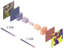
Fig.1
Semantic segmentation network architecture diagram
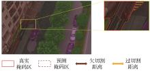
Fig.2
Pixel-wise distance metric space structure
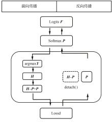
Fig.3
Training and optimization mechanism of STE-Mask

Fig.4
Main process of Lossd loss generation
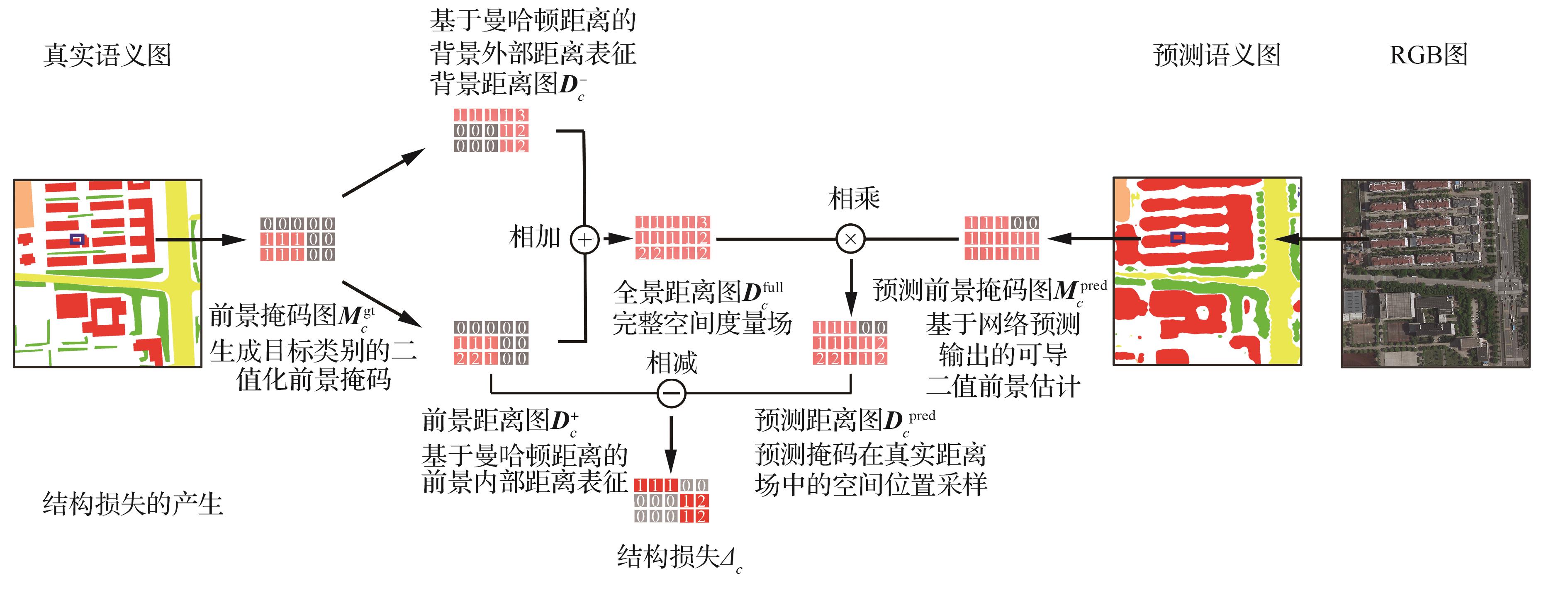
Table 1
Experimental datasets
| 数据集名称 | 数据集划分 | 语义掩码数 | ||
|---|---|---|---|---|
| 训练集 | 验证集 | 测试集 | ||
| UAVid | 1~15,31~35 | 16~20,36,37 | 21~30,38~42 | 8 |
| Potsdam | 2_11,2_12,3_10,3_11,3_12,4_10,4_12, 5_10,5_11,5_12,6_7,6_8,6_9,6_10,6_11, 6_12,7_7,7_8,7_9,7_10,7_11,7_12 | 2_10 | 2_13,2_14,3_13,3_14,4_13,4_14,4_15 5_13,5_14,5_15,6_13,6_14,6_15,7_13 | 6 |
| LoveDA | 0~2 521 | 2 522~4 190 | 4 191~5 986 | 7 |
Table 2
Comparison of various methods on LoveDA dataset
| 类型 | 方法 | 来源 | mIoU/% | IoU pre category/% | ||||||
|---|---|---|---|---|---|---|---|---|---|---|
| 建筑 | 道路 | 水 | 荒地 | 农田 | 背景 | 森林 | ||||
方法 其他先进 | HRNetw32[ | NeurlPS 2021 | 49.8 | 55.3 | 57.4 | 80.0 | 11.1 | 60.9 | 44.6 | 45.2 |
| FactSeg[ | TGRS 2022 | 48.9 | 53.6 | 52.8 | 76.9 | 16.2 | 57.5 | 42.6 | 42.9 | |
| DC-Swin[ | GRSL 2022 | 50.6 | 54.5 | 56.2 | 78.1 | 14.5 | 62.4 | 41.3 | 47.2 | |
| Hi-ResNet[ | JSTARS 2023 | 52.5 | 58.3 | 55.9 | 80.1 | 17.0 | 62.7 | 46.7 | 46.7 | |
| Mask DINO[ | CVPR 2023 | 52.6 | 60.0 | 55.1 | 79.8 | 20.3 | 62.7 | 44.9 | 46.2 | |
| VLTSeg[ | ACCV 2024 | 53.8 | 57.9 | 61.3 | 80.5 | 24.1 | 60.2 | 45.8 | 46.5 | |
| LOGCAN[ | TGRS 2024 | 53.4 | 58.4 | 56.5 | 80.1 | 18.4 | 56.8 | 47.4 | 47.9 | |
| AerialFormer-B[ | RS 2024 | 54.1 | 60.7 | 59.3 | 81.5 | 17.9 | 64.0 | 47.8 | 47.9 | |
| 基准方法 | UNetFormer | ISPRS 2022 | 51.9 | 57.9 | 54.1 | 79.1 | 19.8 | 62.3 | 44.2 | 45.7 |
| MLFMNet-B[ | JSTARS 2024 | 53.1 | 60.8 | 57.2 | 81.3 | 17.5 | 61.6 | 45.8 | 47.4 | |
| SFA-Net | RS 2024 | 54.2 | 61 | 57.8 | 81.4 | 21.5 | 64.8 | 47.3 | 45.8 | |
| Lossd增强方法 | UNetFormer + Ours | 53.4 (+1.5) | 62.1 | 57.5 | 81.8 | 20.3 | 63.0 | 44.9 | 46.1 | |
| MLFMNet-B + Ours | 54.3 (+1.2) | 65.5 | 60.5 | 82.8 | 20.0 | 62.8 | 46.3 | 47.7 | ||
| SFA-Net + Ours | 55.8 (+1.6) | 65.4 | 60.7 | 83.2 | 21.9 | 65.7 | 47.4 | 46.5 | ||
Table 3
Comparison of various methods on UAVid dataset
| 类型 | 方法 | 来源 | mIoU/% | IoU pre category/% | |||||||
|---|---|---|---|---|---|---|---|---|---|---|---|
| 建筑 | 道路 | 树 | 植被 | 运动车 | 静态车 | 行人 | 背景 | ||||
方法 其他先进 | SegFomer[ | NeurlPS 2021 | 65.4 | 85.4 | 79.9 | 78.5 | 61.8 | 71.8 | 52.1 | 27.8 | 66.3 |
| BANet[ | RS 2021 | 66.0 | 84.5 | 80.0 | 78.3 | 61.3 | 58.8 | 52.2 | 19.9 | 66.3 | |
| DC-Swin[ | GRSL 2022 | 68.8 | 88.5 | 82.7 | 80.0 | 64.6 | 74.1 | 59.3 | 30.7 | 70.3 | |
| DecoupleNet D2[ | TGRS 2024 | 65.1 | 84.4 | 79.9 | 78.2 | 61.3 | 73.6 | 48.8 | 30.2 | 64.6 | |
| MMLN[ | JSTARS 2024 | 69.5 | 88.4 | 81.9 | 80.9 | 65.7 | 62.0 | 74.8 | 32.5 | 69.6 | |
| Mask DINO[ | CVPR 2023 | 67.9 | 87.3 | 81.5 | 80.2 | 63.7 | 73.6 | 56.2 | 31.0 | 68.6 | |
| VLTSeg[ | ACCV 2024 | 69.5 | 89.6 | 83.3 | 80.7 | 65.1 | 74.9 | 59.7 | 31.9 | 70.6 | |
基准 方法 | UNetFormer | ISPRS 2022 | 67.4 | 87.2 | 81.1 | 79.8 | 63.1 | 73.3 | 55.9 | 30.6 | 68.2 |
| MLFMNet-B | JSTARS 2024 | 70.0 | 89.5 | 82.2 | 81.0 | 64.3 | 76.1 | 64.7 | 32.3 | 70.0 | |
| SFA-Net | RS 2024 | 69.9 | 88.7 | 82.4 | 80.4 | 64 | 77.1 | 66.9 | 30.2 | 69.7 | |
方法 Lossd增强 | UNetFormer + Ours | 67.8 (+0.4) | 88.1 | 81.9 | 80.2 | 63.3 | 73.5 | 56.2 | 30.9 | 68.5 | |
| MLFMNet-B + Ours | 70.8 (+0.8) | 91.4 | 83.5 | 81.4 | 64.9 | 76.4 | 65.6 | 32.6 | 70.3 | ||
| SFA-Net + Ours | 70.5 (+0.6) | 90.0 | 83.8 | 80.9 | 64.7 | 77.2 | 67.3 | 30.3 | 70.1 | ||
Table 4
Comparison of various methods on Potsdam dataset
| 类型 | 方法 | 来源 | mF1/% | F1 pre category/% | ||||
|---|---|---|---|---|---|---|---|---|
| 硬化面 | 建筑 | 低矮植被 | 树 | 汽车 | ||||
方法 其他先进 | DC-Swin[ | GRSL 2022 | 93.3 | 94.2 | 97.6 | 88.6 | 89.6 | 96.3 |
| EfficientUNets[ | TGRS 2023 | 93.5 | 94.8 | 98.2 | 89.5 | 90.5 | 94.6 | |
| Mask DINO[ | CVPR 2023 | 93.2 | 94.1 | 96.9 | 89.5 | 88.7 | 96.8 | |
| VLTSeg[ | ACCV 2024 | 93.8 | 95.2 | 97.4 | 89.3 | 89.2 | 98.0 | |
| Vit-G12X4[ | JSTARS 2024 | 92.1 | 92.8 | 96.9 | 85.9 | 89.0 | 96.0 | |
| AerialFormer-B[ | RS 2024 | 94.1 | 95.5 | 98.1 | 89.8 | 89.8 | 97.5 | |
| 基准方法 | UNetFormer | ISPRS 2022 | 92.3 | 93.1 | 96.7 | 87.4 | 88.5 | 96.0 |
| MLFMNet-B | JSTARS 2024 | 93.4 | 94.6 | 97.5 | 88.4 | 88.7 | 96.9 | |
| SFA-Net | RS 2024 | 93.2 | 94.6 | 97.2 | 88.1 | 89.5 | 96.7 | |
方法 Lossd 增强 | UNetFormer + Ours | 93.1 (+0.8) | 94.4 | 98.3 | 87.7 | 88.9 | 96.4 | |
| MLFMNet-B + Ours | 94.1 (+0.7) | 96.1 | 98.9 | 89.2 | 89.3 | 97.2 | ||
| SFA-Net + Ours | 94.0 (+0.8) | 96.2 | 98.4 | 88.6 | 90.1 | 96.9 | ||
Fig.5
Performance comparison of SFA-Net model on LoveDA before and after applying Lossd
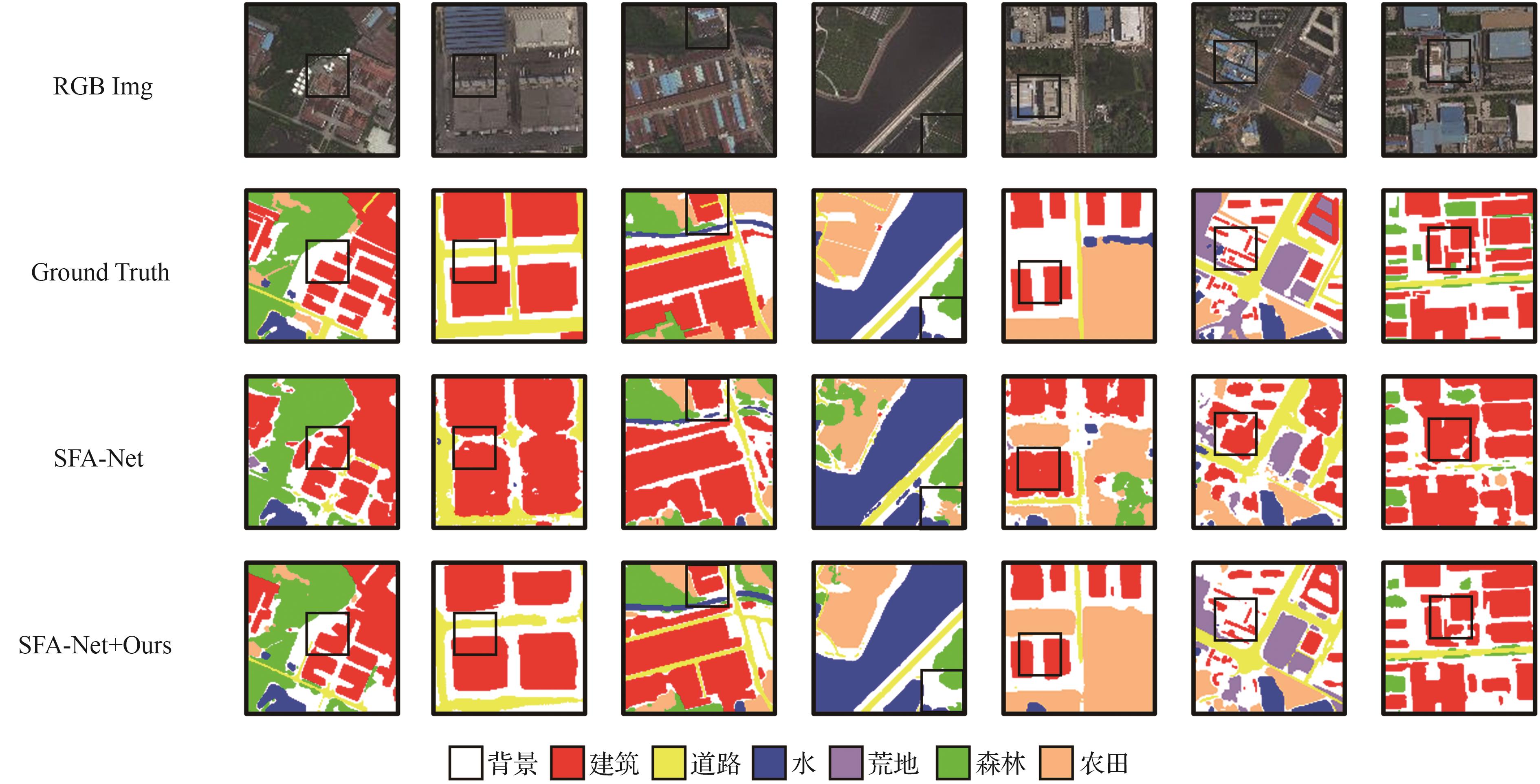
Fig.6
Performance comparison of SFA-Net Model on UAVid before and after applying Lossd
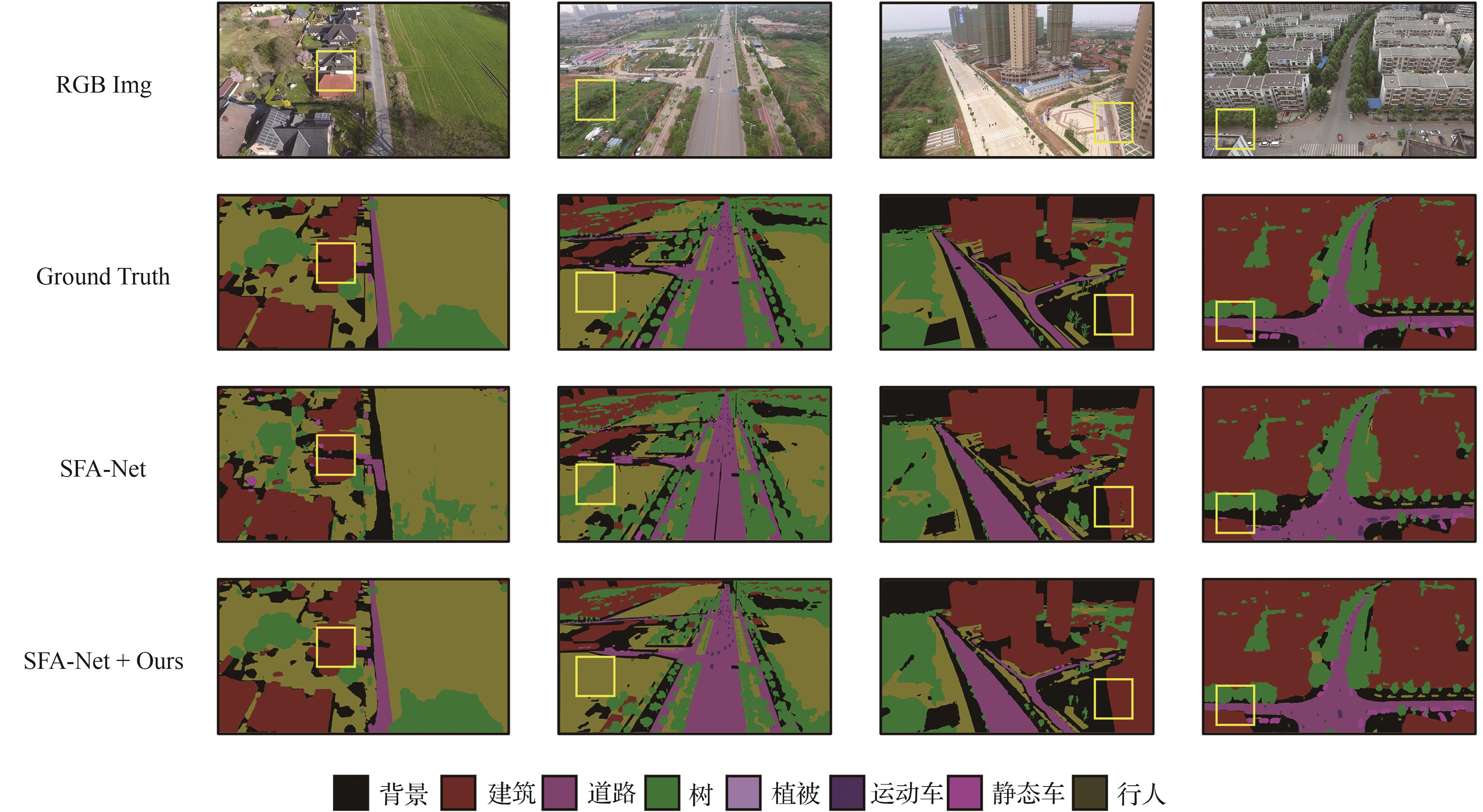
Fig.7
Performance comparison of SFA-Net Model on Postdam before and after applying Lossd
Table 5
Impact of different N on SFA-Net
| 指标 | N=0 | N=50 | N=80 | N=90 | N=100 | N=120 |
|---|---|---|---|---|---|---|
| mIoU/% | 54.2 | 55.1 | 55.4 | 55.6 | 55.2 | 55.0 |
| 变化幅度/% | 0 | +0.9 | +1.2 | +1.4 | +1.0 | +0.8 |
Table 6
Impact of different N on MLFMNet-B
| 指标 | N=0 | N=50 | N=60 | N=70 | N=80 | N=100 |
|---|---|---|---|---|---|---|
| mIoU/% | 53.1 | 53.5 | 53.6 | 54.0 | 53.7 | 53.6 |
| 变化幅度/% | 0 | +0.4 | +0.5 | +0.9 | +0.6 | +0.5 |
Table 7
Impact of different N on UNetFormer
| 指标 | N=0 | N=50 | N=60 | N=70 | N=80 | N=100 |
|---|---|---|---|---|---|---|
| mIoU/% | 51.9 | 52.8 | 52.9 | 53.1 | 52.6 | 52.0 |
| 变化幅度/% | 0 | +0.9 | +1.0 | +1.2 | +0.7 | + 0.1 |
Table 8
Impact of different α on three models
| 模型 | α=0 | α=0.05 | α=0.1 | α=0.2 | α=0.33 | α=0.4 | α=0.5 |
|---|---|---|---|---|---|---|---|
| SFA-Net/% | 54.2 | 55.7(+0.4) | 55.8(+1.6) | 55.6(+1.4) | 54.9(+0.7) | 54.3(+0.1) | 53.4(-0.8) |
| MLFMNet/% | 53.1 | 53.2(+0.1) | 53.5(+0.4) | 53.9(+0.8) | 54.3(+1.2) | 53.7(+0.6) | 53.2(+0.1) |
| UNetFormer/% | 51.9 | 52.2(+0.2) | 52.4(+0.5) | 53.0(+1.2) | 53.4(+1.5) | 52.2(+0.3) | 50.8(-1.3) |
Table 9
Impact of different distance metrics on SFA-Net
| 方法 | 训练时间倍数 | mIoU/% | IoU pre category/% | ||||||
|---|---|---|---|---|---|---|---|---|---|
| 建筑 | 道路 | 水 | 荒地 | 森林 | 农田 | 背景 | |||
| SFA-Net | 1 | 54.2 | 61 | 57.8 | 81.4 | 21.5 | 45.8 | 64.8 | 47.3 |
| SFA-Net+曼哈顿距离 | 1.43 | 55.8(+1.6) | 65.4 | 60.7 | 83.2 | 21.9 | 46.5 | 65.7 | 47.4 |
| SFA-Net+欧几里得距离 | 3.25 | 55.7(+1.4) | 63.6 | 59.8 | 84.0 | 21.9 | 47.1 | 65.3 | 47.5 |
Table 10
Impact of different directions on SFA-Net
| 方法 | mIoU/% |
|---|---|
| SFA-Net | 54.2 |
| SFA-Net+前景距离 | 54.9(+0.7) |
| SFA-Net+背景距离 | 54.3(+0.1) |
| SFA-Net+双向距离 | 55.8(+1.6) |
Table 11
Impact of Lossd on mBIoU
| 方法 | mBIoU/% | BIoU pre category/% | ||||||
|---|---|---|---|---|---|---|---|---|
| 建筑 | 道路 | 水 | 荒地 | 森林 | 农田 | 背景 | ||
| SFA-Net | 23.5 | 25.7 | 21.6 | 54.4 | 6.9 | 14.5 | 30.4 | 11.2 |
| SFA-Net+Lossd | 30.9 | 42.6 | 29.2 | 64.1 | 9.7 | 19.1 | 34.6 | 16.4 |
Table 12
Impact of image resolution on mBIoU
| 分辨率 | mBIoU pre category/% | |
|---|---|---|
| SFA-Net | SFA-Net+Lossd | |
| 224×224 | 19.7 | 23.5(+3.8) |
| 384×384 | 21.1 | 25.6(+4.5) |
| 512×512 | 23.5 | 30.9(+7.4) |
Table 13
Impact of image resolution on mIoU
| 分辨率 | mIoU pre category/% | |
|---|---|---|
| SFA-Net | SFA-Net+Lossd | |
| 224×224 | 53.9 | 55.2(+1.3) |
| 384×384 | 54.1 | 55.6(+1.5) |
| 512×512 | 54.2 | 55.8(+1.6) |
| [1] | 罗旭东, 吴一全, 陈金林. 无人机航拍影像目标检测与语义分割的深度学习方法研究进展[J]. 航空学报, 2024, 45(6): 028822. |
| LUO X D, WU Y Q, CHEN J L. Research progress on deep learning methods for object detection and semantic segmentation in UAV aerial images[J]. Acta Aeronautica et Astronautica Sinica, 2024, 45(6): 028822 (in Chinese). | |
| [2] | 江波, 屈若锟, 李彦冬, 等. 基于深度学习的无人机航拍目标检测研究综述[J]. 航空学报, 2021, 42(4): 524519. |
| JIANG B, QU R K, LI Y D, et al. Object detection in UAV imagery based on deep learning: Review[J]. Acta Aeronautica et Astronautica Sinica, 2021, 42(4): 524519 (in Chinese). | |
| [3] | CHANG F Z, MA T Y, WANG D T, et al. Method for building segmentation and extraction from high-resolution remote sensing images based on improved YOLOv5ds[J]. PLOS One, 2025, 20(3): e0317106. |
| [4] | LIU Q H, KAMPFFMEYER M, JENSSEN R, et al. Multi-modal land cover mapping of remote sensing images using pyramid attention and gated fusion networks[J]. International Journal of Remote Sensing, 2022, 43(9): 3509-3535. |
| [5] | GHAMISI P, YOKOYA N, LI J, et al. Advances in hyperspectral image and signal processing: A comprehensive overview of the state of the art[J]. IEEE Geoscience and Remote Sensing Magazine, 2017, 5(4): 37-78. |
| [6] | LI A J, JIAO L C, ZHU H, et al. Multitask semantic boundary awareness network for remote sensing image segmentation[J]. IEEE Transactions on Geoscience and Remote Sensing, 2022, 60: 5400314. |
| [7] | LIU R, MI L, CHEN Z Z. AFNet: Adaptive fusion network for remote sensing image semantic segmentation[J]. IEEE Transactions on Geoscience and Remote Sensing, 2021, 59(9): 7871-7886. |
| [8] | LI Y X, HOU Q B, ZHENG Z H, et al. Large selective kernel network for remote sensing object detection[C]∥2023 IEEE/CVF International Conference on Computer Vision (ICCV). Piscataway: IEEE Press, 2024: 16748-16759. |
| [9] | WANG L B, LI R, ZHANG C, et al. UNetFormer: A UNet-like transformer for efficient semantic segmentation of remote sensing urban scene imagery[J]. ISPRS Journal of Photogrammetry and Remote Sensing, 2022, 190: 196-214. |
| [10] | WANG D, ZHANG Q M, XU Y F, et al. Advancing plain vision transformer toward remote sensing foundation model[J]. IEEE Transactions on Geoscience and Remote Sensing, 2023, 61: 5607315. |
| [11] | LI R, ZHENG S Y, ZHANG C, et al. ABCNet: Attentive bilateral contextual network for efficient semantic segmentation of Fine-Resolution remotely sensed imagery[J]. ISPRS Journal of Photogrammetry and Remote Sensing, 2021, 181: 84-98. |
| [12] | KERVADEC H, BOUCHTIBA J, DESROSIERS C, et al. Boundary loss for highly unbalanced segmentation[J]. Medical Image Analysis, 2021, 67: 101851. |
| [13] | ZHAO S, WANG Y, YANG Z, et al. Region mutual information loss for semantic segmentation[C]∥Proceedings of the 33rd International Conference on Neural Information Processing Systems. New York:ACM,2019:11117-11127. |
| [14] | LI X L, CHEN J S, ZHAO L L, et al. Adaptive distance-weighted voronoi tessellation for remote sensing image segmentation[J]. Remote Sensing, 2020, 12(24): 4115. |
| [15] | BOKHOVKIN A, BURNAEV E. Boundary loss for remote sensing imagery semantic segmentation[C]∥Advances in Neural Networks-ISNN 2019. Cham: Springer, 2019: 388-401. |
| [16] | GÜL F, APTOULA E. A distance transform based loss function for the semantic segmentation of very high resolution remote sensing images[C]∥IGARSS 2024-2024 IEEE International Geoscience and Remote Sensing Symposium. Piscataway: IEEE Press, 2024: 9888-9891. |
| [17] | BERTASIUS G, SHI J B, TORRESANI L. Semantic segmentation with boundary neural fields[C]∥2016 IEEE Conference on Computer Vision and Pattern Recognition (CVPR). Piscataway: IEEE Press, 2016: 3602-3610. |
| [18] | 文贡坚, 王润生. 从航空遥感图像中自动提取主要道路[J]. 软件学报, 2000, 11(7): 957-964. |
| WEN G J, WANG R S. Automatic extraction of main roads from aerial remote sensing images[J]. Journal of Software, 2000, 11(7): 957-964 (in Chinese). | |
| [19] | SHELHAMER E, LONG J, DARRELL T. Fully convolutional networks for semantic segmentation[J].IEEE Transactions on Pattern Analysis and Machine Intelligence, 2017, 39(4): 640-651 |
| [20] | RONNEBERGER O, FISCHER P, BROX T. U-Net: Convolutional networks for biomedical image segmentation[C]∥Medical Image Computing and Computer-Assisted Intervention-MICCAI 2015. Cham: Springer, 2015: 234-241. |
| [21] | CHEN L C, ZHU Y K, PAPANDREOU G, et al. Encoder-decoder with atrous separable convolution for semantic image segmentation[C]∥Computer Vision-ECCV 2018. Cham: Springer, 2018: 833-851. |
| [22] | BADRINARAYANAN V, KENDALL A, CIPOLLA R. SegNet: A deep convolutional encoder-decoder architecture for image segmentation[J]. IEEE Transactions on Pattern Analysis and Machine Intelligence, 2017, 39(12): 2481-2495. |
| [23] | SHEKHOVTSOV A, YANUSH V. Reintroducing straight-through estimators as principled methods for stochastic binary networks[C]∥Pattern Recognition (DAGM GCPR 2021). Cham: Springer, 2021: 111-126. |
| [24] | WANG J J, ZHENG Z, MA A L, et al. LoveDA: A remote sensing land-cover dataset for domain adaptive semantic segmentation[DB/OL]. arXiv: , 2021. |
| [25] | LYU Y, VOSSELMAN G, XIA G S, et al. UAVid: A semantic segmentation dataset for UAV imagery[J]. ISPRS Journal of Photogrammetry and Remote Sensing, 2020, 165: 108-119. |
| [26] | ISPRS. Potsdam 2D semantic labeling dataset[DB/OL]. (2015-04-01)[2025-06-20]. . |
| [27] | HWANG G, JEONG J, LEE S J. SFA-Net: Semantic feature adjustment network for remote sensing image segmentation[J]. Remote Sensing, 2024, 16(17): 3278. |
| [28] | WEI X Y, RAO L, FAN G Y, et al. MLFMNet: A multilevel feature mining network for semantic segmentation on aerial images[J]. IEEE Journal of Selected Topics in Applied Earth Observations and Remote Sensing, 2024, 17: 16165-16179. |
| [29] | KRIZHEVSKY A, SUTSKEVER I, HINTON G E. ImageNet classification with deep convolutional neural networks[J]. Communications of the ACM, 2017, 60(6): 84-90. |
| [30] | CHENG B W, GIRSHICK R, DOLLÁR P, et al. Boundary IoU: Improving object-centric image segmentation evaluation[C]∥2021 IEEE/CVF Conference on Computer Vision and Pattern Recognition (CVPR). Piscataway: IEEE Press, 2021: 15329-15337. |
| [31] | MA A L, WANG J J, ZHONG Y F, et al. FactSeg: Foreground activation-driven small object semantic segmentation in large-scale remote sensing imagery[J]. IEEE Transactions on Geoscience and Remote Sensing, 2022, 60: 5606216. |
| [32] | WANG L B, LI R, DUAN C X, et al. A novel transformer based semantic segmentation scheme for fine-resolution remote sensing images[J]. IEEE Geoscience and Remote Sensing Letters, 2022, 19: 6506105. |
| [33] | CHEN Y X, FANG P C, ZHONG X L, et al. Hi-ResNet: Edge detail enhancement for high-resolution remote sensing segmentation[J]. IEEE Journal of Selected Topics in Applied Earth Observations and Remote Sensing, 2024, 17: 15024-15040. |
| [34] | LI F, ZHANG H, XU H Z, et al. Mask DINO: Towards a unified transformer-based framework for object detection and segmentation[C]∥2023 IEEE/CVF Conference on Computer Vision and Pattern Recognition (CVPR). Piscataway: IEEE Press, 2023: 3041-3050. |
| [35] | HÜMMER C, SCHWONBERG M, ZHOU L W, et al. Strong but simple: A baseline for domain generalized dense perception by CLIP-based transfer learning[C]∥Computer Vision-ACCV 2024. Singapore: Springer, 2025: 463-484. |
| [36] | MA X W, LIAN R R, WU Z K, et al. LOGCAN++: Adaptive local-global class-aware network for semantic segmentation of remote sensing images[J]. IEEE Transactions on Geoscience and Remote Sensing, 2025, 63: 4404216. |
| [37] | HANYU T, YAMAZAKI K, TRAN M, et al. AerialFormer: Multi-resolution transformer for aerial image segmentation[J]. Remote Sensing, 2024, 16(16): 2930. |
| [38] | XIE E Z, WANG W H, YU Z D, et al. SegFormer: Simple and efficient design for semantic segmentation with transformers[DB/OL]. arXiv preprint: 2105.15203, 2021. |
| [39] | WANG L B, LI R, WANG D Z, et al. Transformer meets convolution: A bilateral awareness network for semantic segmentation of very fine resolution urban scene images[J]. Remote Sensing, 2021, 13(16): 3065. |
| [40] | LU W, CHEN S B, SHU Q L, et al. DecoupleNet: A lightweight backbone network with efficient feature decoupling for remote sensing visual tasks[J]. IEEE Transactions on Geoscience and Remote Sensing, 2024, 62: 4414613. |
| [41] | SUN H, XIE Y C, REN D, et al. MMLN: Multi-directional and multi-constraint learning network for remote sensing imagery semantic segmentation[J]. IEEE Journal of Selected Topics in Applied Earth Observations and Remote Sensing, 2024: 1-16. |
| [42] | ALMARZOUQI H, SAAD SAOUD L. Semantic labeling of high-resolution images using Efficient UNets and transformers[J]. IEEE Transactions on Geoscience and Remote Sensing, 2023, 61: 4402913. |
| [43] | CHA K, SEO J, LEE T. A billion-scale foundation model for remote sensing images[J]. IEEE Journal of Selected Topics in Applied Earth Observations and Remote Sensing, 2024:1-17. |
| [1] | Jun HUANG, Jing ZHANG, Shiqian WENG. Airborne electro-optical target recognition algorithms [J]. Acta Aeronautica et Astronautica Sinica, 2026, 47(6): 332601-332601. |
| [2] | Leyan LI, Rennong YANG, Anxin GUO, Qi SONG, Jialiang ZUO. Beyond-visual-range air combat threat prediction and dynamic evasion method based on all-domain fire field theory [J]. Acta Aeronautica et Astronautica Sinica, 2026, 47(4): 332205-332205. |
| [3] | Zicheng FENG, Wenlong ZHANG, Donghui LIU, Qifeng YU. Robust infrared target tracking algorithm for anti-UAV in complexbackgrounds [J]. Acta Aeronautica et Astronautica Sinica, 2026, 47(4): 332264-332264. |
| [4] | Ye TAO, Jinhui TANG, Zhen YAN, Chen ZHOU, Chong WANG. A trajectory imputation method integrating representation transformation and pattern regression [J]. Acta Aeronautica et Astronautica Sinica, 2026, 47(1): 332106-332106. |
| [5] | Jianyu XU, Li ZHOU, Zhanxue WANG, Jie SHI, Hao SHI. Calculation method for hypersonic plume infrared radiation based on a fast line-by-line calculation model [J]. Acta Aeronautica et Astronautica Sinica, 2025, 46(8): 630778-630778. |
| [6] | Lingjie MENG, Hongguang LI, Xinjun LI. SAR image simulation method guided by geomorphic category information [J]. Acta Aeronautica et Astronautica Sinica, 2025, 46(7): 331003-331003. |
| [7] | Zhihao ZHAO, Zhaohua YANG, Yun WU, Yuanjin YU. Single-photon counting imaging denoising method based on deep learning in low-light environment [J]. Acta Aeronautica et Astronautica Sinica, 2025, 46(3): 630531-630531. |
| [8] | Yiquan WU, Kang TONG. Research advances on deep learning-based small object detection in UAV aerial images [J]. Acta Aeronautica et Astronautica Sinica, 2025, 46(3): 30848-030848. |
| [9] | Zijian XIANG, Zhenyu MA, Xixiang YANG. Inversion of structural performance parameters of composite materials based on deep learning [J]. Acta Aeronautica et Astronautica Sinica, 2025, 46(24): 231877-231877. |
| [10] | Runmin CONG, Haoyan SUN, Yuxuan LUO, Hao FANG. Generalized few-shot segmentation for remote sensing image based on class relation mining [J]. Acta Aeronautica et Astronautica Sinica, 2025, 46(23): 631694-631694. |
| [11] | Tianqi FAN, Zhengxia ZOU, Zhenwei SHI. Typical remote sensing target detection with data synthesis based on reinforcement learning [J]. Acta Aeronautica et Astronautica Sinica, 2025, 46(23): 631955-631955. |
| [12] | Kui LIU, Hao SUN, Han WU, Kefeng JI, Gangyao KUANG. Dynamic brightness reconstruction for UAV visible-infrared fusion object detection [J]. Acta Aeronautica et Astronautica Sinica, 2025, 46(23): 631968-631968. |
| [13] | Bo PENG, Jikang BAI, Weiwen CHEN, Xiangtao ZHENG, Jianjun LEI, Xiaoqiang LU. Research progress for UAV search and rescue methods based on deep learning [J]. Acta Aeronautica et Astronautica Sinica, 2025, 46(23): 632761-632761. |
| [14] | Jiaxin LI, Shuaishuai LYU, Yezi WANG, Yu YANG, Ziyue LI. Transformer-based intelligent tracking method of aviation structure surface cracks [J]. Acta Aeronautica et Astronautica Sinica, 2025, 46(21): 532355-532355. |
| [15] | Xiaowei JIANG, Yiquan WU. Research progress of UAV aerial image mosaic methods [J]. Acta Aeronautica et Astronautica Sinica, 2025, 46(17): 331799-331799. |
| Viewed | ||||||
|
Full text |
|
|||||
|
Abstract |
|
|||||
Address: No.238, Baiyan Buiding, Beisihuan Zhonglu Road, Haidian District, Beijing, China
Postal code : 100083
E-mail:hkxb@buaa.edu.cn
Total visits: 6658907 Today visits: 1341All copyright © editorial office of Chinese Journal of Aeronautics
All copyright © editorial office of Chinese Journal of Aeronautics
Total visits: 6658907 Today visits: 1341