Acta Aeronautica et Astronautica Sinica ›› 2026, Vol. 47 ›› Issue (10): 632103.doi: 10.7527/S1000-6893.2025.32103
• Special Issue: Intelligent Processing and Analysis of Aerospace Remote Sensing Images • Previous Articles
Ruotian REN1,2, Lijun ZHAO1( ), Xuyang ZHAO1,2, Zheng ZHANG1, Hongyi LI1, Xinhua XUE3, Ping TANG1
Received:2025-04-10
Revised:2025-05-08
Accepted:2025-05-29
Online:2025-06-11
Published:2025-06-10
Contact:
Lijun ZHAO
E-mail:zhaolj201934@aircas.ac.cn
Supported by:CLC Number:
Ruotian REN, Lijun ZHAO, Xuyang ZHAO, Zheng ZHANG, Hongyi LI, Xinhua XUE, Ping TANG. A review of knowledge-guided intelligent interpretation methods for remote sensing imagery[J]. Acta Aeronautica et Astronautica Sinica, 2026, 47(10): 632103.
Table 1
Current mainstream types of remote sensing interpretation tasks
| 解译任务 | 任务描述 | 示例数据集 | 示例输入 | 示例输出 |
|---|---|---|---|---|
| 目标检测 | 从遥感图像中自动识别并定位感兴趣的地物目标,同时输出目标的类别信息和空间位置信息 | RSOD[ |  |  |
| 语义分割 | 对遥感图像中的每个像素进行分类,赋予对应的语义类别标签,从而实现对地表覆盖或地物目标的精细化解析 | Aerial image segmentation dataset[ |  |  |
| 变化检测 | 对比同一地理区域在不同时间获取的遥感影像,识别地表覆盖或地物目标在时间维度上的变化区域,并进一步确定变化的类型和强度 | Onera satellite change detection dataset[ |  |  |
| 场景分类 | 根据遥感图像的整体内容和上下文信息,将整幅图像划分到预定义的场景类别中 | SIRI-WHU[ |  |  |
| 图像理解 | 通过对遥感图像的内容分析,自动生成自然语言描述,以准确、简洁地概括图像中的关键地物、空间布局和语义场景信息 | UCM-Captions[ |  |  |
Table 2
Types and specific meanings of knowledge in remote sensing image interpretation
| 序号 | 解译知识类型 | 具体含义 |
|---|---|---|
| 1 | 影像数据实体 | 影像数据实体通过物理规则、几何约束等结构化属性承载着最显性的领域知识。对实体数据进行优化、扩增等操作,可抑制噪声等的干扰,构建高保真、强适配的解译数据基底 |
| 2 | 遥感指数特征 | 利用遥感影像的不同波段数据进行代数运算,获取用于描述特定地物特征的遥感指数,如归一化植被指数、归一化水体指数、归一化建筑指数等 |
| 3 | 影像地理知识 | 遥感影像的地理位置信息与特定的地表覆盖产品(如GlobalLand30),将两者结合能够反映出该地理区域内不同地物类型的分布特征与规律 |
| 4 | 对象知识图谱 | 针对遥感影像中不同对象之间关系构建知识图谱,如形状、颜色等数据关系,拥有、组成等对象关系,包含、相交等拓扑关系 |
| 5 | 图像模态特征 | 基于不同成像系统获取的不同模态的遥感影像往往会包含特定领域下的特征,如光学成像系统注重于图像的光谱特征。此外,通过深度学习模型等手段能够挖掘数据的深层次信息,这也属于图像模态的范畴。不同模态的数据能够有机融合,达到特征互补的目的 |
| 6 | 衍生属性特征 | 真实场景下,物体的成像效果常伴随不同衍生属性(如飞机尾波、建筑阴影等),而在神经网络中,较大的感受野能够捕获更多的地物细节与属性,这些衍生特征均能够作为解译任务的先验知识 |
| 7 | 解译网络构件 | 解译网络构件是指构成遥感智能解译模型的基础知识单元,涵盖完整网络架构、网络功能模块及优化策略。通过领域知识引导构件设计与组合,能搭建有效服务于主线解译任务或分支辅助任务的自适应解译网络模型 |

Fig.1
Different-category knowledge-guided intelligent interpretation methods for remote sensing
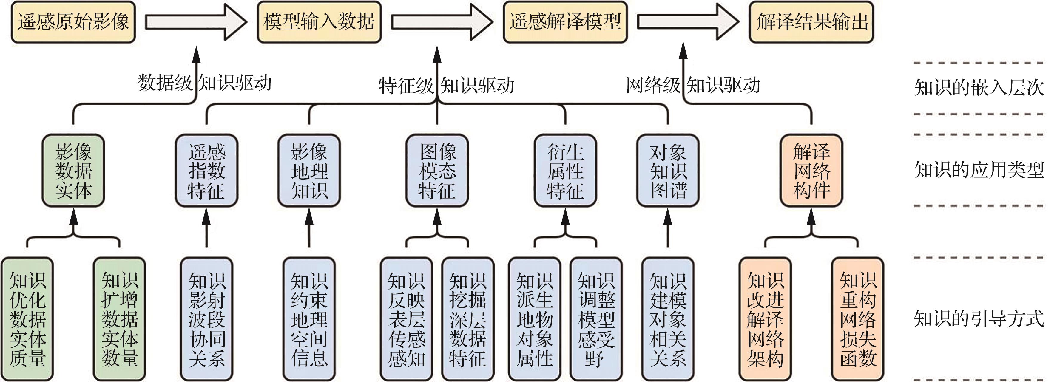
Table 3
Representative knowledge-guided methods for different interpretation tasks
| 解译任务 | 知识引导方法 | 知识侧重类型 |
|---|---|---|
| 目标检测 | 采用伪标签生成与自适应阈值选择策略的弱监督目标检测[ | 影像数据实体 |
| 引入域自适应方法改进Faster RCNN,并与对抗学习结合进行飞机目标检测[ | 图像模态特征 | |
| 结合多尺度感受野增强与扩展卷积,用于光学遥感影像实时小目标检测[ | 衍生属性特征 | |
| 解耦建筑物主体和边缘,结合多目标损失函数增强建筑物边缘特征提取的针对性[ | 衍生属性特征 | |
| 依赖桥梁的边缘、几何与背景特性构建边界框转换模块,检测桥梁的定向边界[ | 衍生属性特征 | |
| 构建空间语义知识图谱与联合关系推理模块,提升目标特征表示的鲁棒性[ | 对象知识图谱 | |
| 引入辅助特征提取网络,改进自适应多特征融合的YOLOv3目标检测网络[ | 解译网络构件 | |
| 形状自适应排斥约束与定向回归损失引导的遥感目标检测[ | 解译网络构件 | |
| 辅助边缘检测任务、结构感知扩展模块和改进边缘结构感知损失结合下的建筑物提取[ | 解译网络构件 | |
| 设计先验知识提取模块获取目标的局部空间信息,增强模型对目标空间上下文的先验理解[ | 解译网络构件 | |
| 语义分割 | 将多模态的遥感指数计算结果作为真值,添加知识重构分支监督网络的训练[ | 遥感指数特征 |
| 集成GIS公共地图数据集与U-Net语义分割网络改进建筑物的提取结果[ | 影像地理知识 | |
| 融合激光雷达点云数据和相机光学图像的车道线分割[ | 图像模态特征 | |
| 综合多模态遥感数据,并设计多阶段融合多源注意力网络提升模态特征的可辨性[ | 图像模态特征 | |
| 基于协同增强融合模块挖掘多源遥感影像的互补特征,同时利用多尺度解码器学习尺度不变性特征[ | 图像模态特征 | |
| 利用地学知识图谱获取空间语义知识,构建地物实体的不同约束引导语义分割网络的训练[ | 对象知识图谱 | |
| 变化检测 | 利用面向对象的孪生神经网络进行遥感影像建筑物变化检测,并通过生成对抗网络实现样本迁移[ | 影像数据实体 |
| 基于空间光谱特征和度量学习生成伪标签,并结合孪生神经网络与图神经网络进行变化检测[ | 影像数据实体 | |
| 在光谱、空间、纹理等属性特征的基础上,基于加权相似距离等信息融合策略完成监督变化检测任务[ | 衍生属性特征 | |
| 结合多任务学习与深度孪生网络的遥感影像多类变化检测[ | 解译网络构件 | |
| 设计孪生神经网络并针对空间与光谱信息的重要程度构造加权损失,应用于高光谱变化检测[ | 解译网络构件 | |
| 场景分类 | 改进GAN网络用于生成高分辨率场景分类注释样本,并利用Wasserstein距离优化样本质量[ | 影像数据实体 |
| 基于GAN网络构建孪生神经网络架构,学习来自不同域影像的不变特征实现跨域场景分类[ | 影像数据实体 | |
| 提出对比空间预训练方法,在预训练、微调等阶段结合影像地理空间信息进行自监督学习[ | 影像地理知识 | |
| 融合多尺度、多层次视觉特征生成深度嵌入判别特征,基于增强特征提取框架实现场景分类[ | 衍生属性特征 | |
| 针对地理对象的空间与拓扑关系,联合卷积神经网络与图神经网络,并利用联合损失约束网络参数的更新[ | 对象知识图谱 | |
| 基于Wasserstein距离构建损失函数,同时将类间语义关系知识嵌入到模型中[ | 解译网络构件 | |
| 旋转影像数据得到图像对,利用孪生网络结构与MSE损失对比目标相似性[ | 解译网络构件 | |
| 结合对比学习与Vision Transformer,并提出交叉熵损失和监督对比损失的联合损失函数帮助模型学习更多的判别性特征[ | 解译网络构件 | |
| 结合CNN与Vision Transformer分别获取高分辨率影像的结构特征和语义特征,同时定义联合损失优化联合模型[ | 解译网络构件 | |
| 将Vision Transformer作为教师网络,ResNet作为学生网络进行知识蒸馏[ | 解译网络构件 | |
| 图像理解 | 利用U-Net生成变化检测伪标签为图像理解任务提供更丰富的语义信息,实现对图像差异的细致化 理解[ | 影像数据实体 |
| 基于域自适应获取多尺度的影像特征,缓解自然影像与遥感影像的域差距[ | 图像模态特征 | |
| 利用CNN提取影像场景中的不同属性特征并赋予不同注意力权重,提升图像信息的利用率[ | 衍生属性特征 | |
| 将ResNet作为编码器,并围绕自注意力机制和LSTM(long short-term memory)设计解码器,解决多尺度问题[ | 解译网络构件 | |
| 通过建立对象与场景的关系先验改进Transformer模块,引导模型选择与场景更相关的对象[ | 解译网络构件 | |
使用CNN和CLIP提取区域特征,并通过全局分组与网状交叉注意力机制优化描述性文本的生成 质量[ | 解译网络构件 | |
| 基于CNN和LSTM对原始影像编码与解码,并提出截断交叉熵损失缓解过拟合问题[ | 解译网络构件 | |
设计以Transformer为基础的辅助任务分支用于多标签场景分类,来改进图像理解分支的语义学习 能力[ | 解译网络构件 | |
构建大规模多模态遥感数据集,基于Transformer提出全新的微调方法用于多传感器图像理解和视觉任务 处理[ | 解译网络构件 |
| [1] | 翁星星, 庞超, 许博文, 等. 面向遥感图像解译的增量深度学习[J]. 电子与信息学报, 2024, 46(10): 3979-4001. |
| WENG X X, PANG C, XU B W, et al. Incremental deep learning for remote sensing image interpretation[J]. Journal of Electronics & Information Technology, 2024, 46(10): 3979-4001 (in Chinese). | |
| [2] | CORTES C, VAPNIK V. Support-vector networks[J]. Machine Learning, 1995, 20(3): 273-297. |
| [3] | BREIMAN L. Random forests[J]. Machine Learning, 2001, 45(1): 5-32. |
| [4] | 李彦胜, 武康, 欧阳松, 等. 地学知识图谱引导的遥感影像语义分割[J]. 遥感学报, 2024, 28(2): 455-469. |
| LI Y S, WU K, OUYANG S, et al. Geographic knowledge graph-guided remote sensing image semantic segmentation[J]. National Remote Sensing Bulletin, 2024, 28(2): 455-469 (in Chinese). | |
| [5] | 张戬, 高雅. 深度学习遥感影像解译技术在耕地保护中的应用[J]. 测绘通报, 2023(8): 142-145. |
| ZHANG J, GAO Y. Application of deep learning remote sensing image interpretation technology in cultivated land protection[J]. Bulletin of Surveying and Mapping, 2023(8): 142-145 (in Chinese). | |
| [6] | 付琨, 王佩瑾, 冯瑛超, 等. 遥感跨模态智能解译: 模型、数据与应用[J]. 中国科学: 信息科学, 2023, 53(8): 1529-1559. |
| FU K, WANG P J, FENG Y C, et al. Cross-modal remote sensing intelligent interpretation: Method, data, and application[J]. Scientia Sinica (Informationis), 2023, 53(8): 1529-1559 (in Chinese). | |
| [7] | 李彦胜, 张永军. 耦合知识图谱和深度学习的新一代遥感影像解译范式[J]. 武汉大学学报(信息科学版), 2022, 47(8): 1176-1190. |
| LI Y S, ZHANG Y J. A new paradigm of remote sensing image interpretation by coupling knowledge graph and deep learning[J]. Geomatics and Information Science of Wuhan University, 2022, 47(8): 1176-1190 (in Chinese). | |
| [8] | 周培诚, 程塨, 姚西文, 等. 高分辨率遥感影像解译中的机器学习范式[J]. 遥感学报, 2021, 25(1): 182-197. |
| ZHOU P C, CHENG G, YAO X W, et al. Machine learning paradigms in high-resolution remote sensing image interpretation[J]. National Remote Sensing Bulletin, 2021, 25(1): 182-197 (in Chinese). | |
| [9] | 刘延芳, 佘佳宇, 袁秋帆, 等. 无人机遥感图像实时小目标检测方法[J]. 航空学报, 2024, 45(14): 630119. |
| LIU Y F, SHE J Y, YUAN Q F, et al. Real-time small target detection networks for UAV remote sensing[J]. Acta Aeronautica et Astronautica Sinica, 2024, 45(14): 630119 (in Chinese). | |
| [10] | 杨俊俐, 姜志国, 周全, 等. 基于条件随机场的遥感图像语义标注[J]. 航空学报, 2015, 36(9): 3069-3081. |
| YANG J L, JIANG Z G, ZHOU Q, et al. Remote sensing image semantic labeling based on conditional random field[J]. Acta Aeronautica et Astronautica Sinica, 2015, 36(9): 3069-3081 (in Chinese). | |
| [11] | LONG Y, GONG Y P, XIAO Z F, et al. Accurate object localization in remote sensing images based on convolutional neural networks[J]. IEEE Transactions on Geoscience and Remote Sensing, 2017, 55(5): 2486-2498. |
| [12] | XIAO Z F, LIU Q, TANG G F, et al. Elliptic Fourier transformation-based histograms of oriented gradients for rotationally invariant object detection in remote-sensing images[J]. International Journal of Remote Sensing, 2015, 36(2): 618-644. |
| [13] | KAISER P, WEGNER J D, LUCCHI A, et al. Learning aerial image segmentation from online maps[J]. IEEE Transactions on Geoscience and Remote Sensing, 2017, 55(11): 6054-6068. |
| [14] | DAUDT R C, LE SAUX B, BOULCH A, et al. Urban change detection for multispectral earth observation using convolutional neural networks[C]∥IGARSS 2018-2018 IEEE International Geoscience and Remote Sensing Symposium. Piscataway: IEEE Press, 2018: 2115-2118. |
| [15] | ZHAO B, ZHONG Y F, XIA G S, et al. Dirichlet-derived multiple topic scene classification model for high spatial resolution remote sensing imagery[J]. IEEE Transactions on Geoscience and Remote Sensing, 2016, 54(4): 2108-2123. |
| [16] | QU B, LI X L, TAO D C, et al. Deep semantic understanding of high resolution remote sensing image[C]∥2016 International Conference on Computer, Information and Telecommunication Systems (CITS). Piscataway: IEEE Press, 2016: 1-5. |
| [17] | 孟瑜, 陈静波, 张正, 等. 知识与数据驱动的遥感图像智能解译: 进展与展望[J]. 遥感学报, 2024, 28(11): 2698-2718. |
| MENG Y, CHEN J B, ZHANG Z, et al. Knowledge and data driven remote sensing image interpretation: Recent developments and prospects[J]. National Remote Sensing Bulletin, 2024, 28(11): 2698-2718 (in Chinese). | |
| [18] | 王斯健. 控制点图元库的卫星影像高精度几何校正方法研究[J]. 测绘通报, 2021(S1): 183-187. |
| WANG S J. Research on high-precision geometric correction method of satellite imagery based on control point image element database[J]. Bulletin of Surveying and Mapping, 2021(S1): 183-187. | |
| [19] | 彭泽, 刘定生. 北京一号小卫星几何纠正方法与试验[J]. 遥感信息, 2008, 23(1): 74-77. |
| PENG Z, LIU D S. Method and experiments for geometric rectification of Beijing-1 satellite[J]. Remote Sensing Information, 2008, 23(1): 74-77 (in Chinese). | |
| [20] | 牛超. 基于高光谱遥感的内陆水体辐射校正与水环境参量反演[D]. 上海: 华东师范大学, 2024. |
| NIU C. Radiation correction of inland water bodies and inversion of water environment parameters based on hyperspectral remote sensing[D]. Shanghai: East China Normal University, 2024 (in Chinese). | |
| [21] | 杜宁, 耿宏, 邢承滨. 珞珈一号夜间灯光影像去噪方法研究[J]. 测绘科学, 2024, 49(11): 64-73. |
| DU N, GENG H, XING C B. Research on denoising methods for night light images of Luojia-01[J]. Science of Surveying and Mapping, 2024, 49(11): 64-73 (in Chinese). | |
| [22] | 谭军辉, 颜志宇, 关国翔, 等. 海岛开发利用遥感智能解译技术研究与应用[J]. 测绘通报, 2024(12): 132-136. |
| TAN J H, YAN Z Y, GUAN G X, et al. Research and application of remote sensing intelligent interpretation platform for island development and utilization[J]. Bulletin of Surveying and Mapping, 2024(12): 132-136 (in Chinese). | |
| [23] | 白宽宽, 李志威, 张鹏, 等. 基于多源遥感解译的洞庭湖区自然湖岸线演变过程研究[J]. 湖泊科学, 2024, 36(5): 1537-1549. |
| BAI K K, LI Z W, ZHANG P, et al. Shoreline evolution of natural lakes in Lake Dongting area based on multi-source remote sensing interpretation[J]. Journal of Lake Sciences, 2024, 36(5): 1537-1549 (in Chinese). | |
| [24] | 杨豹, 赵瑞志, 王海波, 等. 遥感技术对地质灾害早期识别和动态监测: 以昌波乡至羊拉乡段为例[J]. 科学技术与工程, 2024, 24(5): 1823-1836. |
| YANG B, ZHAO R Z, WANG H B, et al. Remote sensing technology for early recognition and dynamic monitoring of geological disasters: Take changbo township to yangla township section as an example[J]. Science Technology and Engineering, 2024, 24(5): 1823-1836 (in Chinese). | |
| [25] | 孟浩然, 李存军, 郑翔宇, 等. 综合光谱纹理和时序信息的油茶遥感提取研究[J]. 光谱学与光谱分析, 2023, 43(5): 1589-1597. |
| MENG H R, LI C J, ZHENG X Y, et al. Research on extraction of camellia oleifera by integrating spectral, texture and time sequence remote sensing information[J]. Spectroscopy and Spectral Analysis, 2023, 43(5): 1589-1597 (in Chinese). | |
| [26] | 陈超, 梁锦涛, 杨刚, 等. 面向土地覆盖精准分类的遥感特征参数优选方法[J]. 测绘学报, 2024, 53(7): 1401-1416. |
| CHEN C, LIANG J T, YANG G, et al. Remote sensing parameters optimization for accurate land cover classification[J]. Acta Geodaetica et Cartographica Sinica, 2024, 53(7): 1401-1416 (in Chinese). | |
| [27] | 唐吉文. 形状特征在遥感图像目标检测深度网络模型中的应用研究[D]. 北京: 中国科学院大学, 2021. |
| TANG J W. The application of shape feature to remote sensing image object detection deep network models[D]. Beijing: University of Chinese Academy of Sciences, 2021 (in Chinese). | |
| [28] | 宋翠玉, 李培军, 杨锋杰. 运用多尺度图像纹理进行城市扩展变化检测[J]. 国土资源遥感, 2006, 18(3): 37-42. |
| SONG C Y, LI P J, YANG F J. The application of multiscale image texture to the detection of urban expansion[J]. Remote Sensing for Land & Resources, 2006, 18(3): 37-42 (in Chinese). | |
| [29] | 顾海燕, 杨懿, 李海涛, 等. 高分辨率遥感影像样本库动态构建与智能解译应用[J]. 测绘学报, 2024, 53(6): 1165-1179. |
| GU H Y, YANG Y, LI H T, et al. Dynamic construction of high-resolution remote sensing image sample datasets and intelligent interpretation applications[J]. Acta Geodaetica et Cartographica Sinica, 2024, 53(6): 1165-1179 (in Chinese). | |
| [30] | 张继贤, 顾海燕, 杨懿, 等. 高分辨率遥感影像智能解译研究进展与趋势[J]. 遥感学报, 2021, 25(11): 2198-2210. |
| ZHANG J X, GU H Y, YANG Y, et al. Research progress and trend of high-resolution remote sensing imagery intelligent interpretation[J]. National Remote Sensing Bulletin, 2021, 25(11): 2198-2210 (in Chinese). | |
| [31] | 黄友文, 豆恒, 肖贵光. 融合分类校正与样本扩增的小样本目标检测[J]. 计算机工程与应用, 2024, 60(1): 254-262. |
| HUANG Y W, DOU H, XIAO G G. Few-shot object detection based on fusion of classification correction and sample amplification[J]. Computer Engineering and Applications, 2024, 60(1): 254-262 (in Chinese). | |
| [32] | GOODFELLOW Ⅰ, POUGET-ABADIE J, MIRZA M, et al. Generative adversarial nets[J]. Advances in Neural Information Processing Systems, 2014, 27: 2672-2680. |
| [33] | JOZDANI S, CHEN D M, POULIOT D, et al. A review and meta-analysis of generative adversarial networks and their applications in remote sensing[J]. International Journal of Applied Earth Observation and Geoinformation, 2022, 108: 102734. |
| [34] | ZHU J Y, PARK T, ISOLA P, et al. Unpaired image-to-image translation using cycle-consistent adversarial networks[C]∥2017 IEEE International Conference on Computer Vision (ICCV). Piscataway: IEEE Press, 2017: 2242-2251. |
| [35] | ISOLA P, ZHU J Y, ZHOU T H, et al. Image-to-image translation with conditional adversarial networks[C]∥2017 IEEE Conference on Computer Vision and Pattern Recognition (CVPR). Piscataway: IEEE Press, 2017: 5967-5976. |
| [36] | RADFORD A, METZ L, CHINTALA S. Unsupervised representation learning with deep convolutional generative adversarial networks[DB/OL]. arXiv preprint: 1511.06434, 2015. |
| [37] | 谢威夷, 徐锡杰, 芮小平, 等. 基于Pix2pix网络的遥感影像样本扩增方法[J]. 遥感技术与应用, 2024, 39(5): 1151-1158. |
| XIE W Y, XU X J, RUI X P, et al. Remote sensing image sample augmentation method based on Pix2pix network[J]. Remote Sensing Technology and Application, 2024, 39(5): 1151-1158 (in Chinese). | |
| [38] | 张翔, 孙宪坤, 胡峻, 等. 结合数据扩增与残差收缩网络的地震短临预测[J]. 地震, 2022, 42(2): 74-88. |
| ZHANG X, SUN X K, HU J, et al. Short-term and imminent earthquake prediction combined with data augmentation and residual shrinkage network[J]. Earthquake, 2022, 42(2): 74-88 (in Chinese). | |
| [39] | 马洪祥. 基于对抗学习的遥感图像数据增强技术研究[D]. 西安: 西安电子科技大学, 2021. |
| MA H X. Research on remote sensing image data augmentation based on adversarial learning[D]. Xi’an: Xidian University, 2021 (in Chinese). | |
| [40] | ZHU D J, XIA S X, ZHAO J Q, et al. Diverse sample generation with multi-branch conditional generative adversarial network for remote sensing objects detection[J]. Neurocomputing, 2020, 381: 40-51. |
| [41] | 冀锐, 马磊, 张靖, 等. 基于生成对抗网络的遥感光学影像舰船样本仿真[J]. 北京大学学报(自然科学版), 2024, 60(5): 883-892. |
| JI R, MA L, ZHANG J, et al. Synthesis of remote sensing optical images with ship targets based on generative adversarial networks[J]. Acta Scientiarum Naturalium Universitatis Pekinensis, 2024, 60(5): 883-892 (in Chinese). | |
| [42] | LI Y S, ZHOU Y H, ZHANG Y J, et al. DKDFN: Domain knowledge-guided deep collaborative fusion network for multimodal unitemporal remote sensing land cover classification[J]. ISPRS Journal of Photogrammetry and Remote Sensing, 2022, 186: 170-189. |
| [43] | YAN L, YANG J B, WANG J. Domain knowledge-guided self-supervised change detection for remote sensing images[J]. IEEE Journal of Selected Topics in Applied Earth Observations and Remote Sensing, 2023, 16: 4167-4179. |
| [44] | 崔宾阁, 吴景, 李心慧, 等. 结合深度学习和植被指数的滨海湿地高分二号遥感影像信息提取[J]. 遥感学报, 2023, 27(6): 1376-1386. |
| CUI B G, WU J, LI X H, et al. Combination of deep learning and vegetation index for coastal wetland mapping using GF-2 remote sensing images[J]. National Remote Sensing Bulletin, 2023, 27(6): 1376-1386 (in Chinese). | |
| [45] | LI W Y, CHEN K Y, CHEN H, et al. Geographical knowledge-driven representation learning for remote sensing images[J]. IEEE Transactions on Geoscience and Remote Sensing, 2021, 60: 5405516. |
| [46] | LI W Y, CHEN K Y, SHI Z W. Geographical supervision correction for remote sensing representation learning[J]. IEEE Transactions on Geoscience and Remote Sensing, 2022, 60: 5411520. |
| [47] | 杨昭颖, 韩灵怡, 郑向向, 等. 基于卷积神经网络的遥感影像及DEM滑坡识别: 以黄土滑坡为例[J]. 自然资源遥感, 2022, 34(2): 224-230. |
| YANG Z Y, HAN L Y, ZHENG X X, et al. Landslide identification using remote sensing images and DEM based on convolutional neural network: A case study of loess landslide[J]. Remote Sensing for Natural Resources, 2022, 34(2): 224-230 (in Chinese). | |
| [48] | ESPINOSA M, CROWLEY E J. Generate your own scotland: Satellite image generation conditioned on maps[DB/OL]. arXiv preprint: 2308.16648, 2023. |
| [49] | 王子玲, 熊振宇, 顾祥岐. 可见光与SAR多源遥感图像关联学习算法[J]. 航空学报, 2022, 43(S1): 727239. |
| WANG Z L, XIONG Z Y, GU X Q. Correlation learning algorithm of visible light and SAR cross modal remote sensing images[J]. Acta Aeronautica et Astronautica Sinica, 2022, 43(S1): 727239 (in Chinese). | |
| [50] | ZHOU W J, LI Y Z, HUAN J, et al. MSTNet-KD: Multilevel transfer networks using knowledge distillation for the dense prediction of remote-sensing images[J]. IEEE Transactions on Geoscience and Remote Sensing, 2024, 62: 4504612. |
| [51] | 刘凡凡, 朱成梅, 赵娜娜, 等. 基于多模态融合的遥感小目标检测[J]. 激光与光电子学进展, 2024, 61(24): 2428010. |
| LIU F F, ZHU C M, ZHAO N N, et al. Remote sensing small target detection based on multimodal fusion[J]. Laser & Optoelectronics Progress, 2024, 61(24): 2428010 (in Chinese). | |
| [52] | 胡宇翔, 余长宏, 高明. 多模态融合的遥感图像语义分割网络[J]. 计算机工程与应用, 2024, 60(15): 234-242. |
| HU Y X, YU C H, GAO M. Remote sensing image semantic segmentation network based on multimodal fusion[J]. Computer Engineering and Applications, 2024, 60(15): 234-242 (in Chinese). | |
| [53] | 张银胜, 单梦姣, 陈昕, 等. 基于多模态特征提取与层级感知的遥感图像分割[J]. 地球信息科学学报, 2024, 26(12): 2741-2758. |
| ZHANG Y S, SHAN M J, CHEN X, et al. Remote sensing image segmentation based on multi-modal feature extraction and hierarchical perception[J]. Journal of Geo-Information Science, 2024, 26(12): 2741-2758 (in Chinese). | |
| [54] | WU X, HONG D F, CHANUSSOT J. Convolutional neural networks for multimodal remote sensing data classification[J]. IEEE Transactions on Geoscience and Remote Sensing, 2021, 60: 5517010. |
| [55] | SHARMA M, DHANARAJ M, KARNAM S, et al. YOLOrs: Object detection in multimodal remote sensing imagery[J]. IEEE Journal of Selected Topics in Applied Earth Observations and Remote Sensing, 2021, 14: 1497-1508. |
| [56] | GAO K L, YU A Z, YOU X, et al. Integrating multiple sources knowledge for class asymmetry domain adaptation segmentation of remote sensing images[J]. IEEE Transactions on Geoscience and Remote Sensing, 2023, 62: 5602418. |
| [57] | 姚琴风, 宁永香, 杜孙稳. 基于域自适应神经网络的光学与合成孔径雷达遥感图像变化检测[J]. 激光与光电子学进展, 2024, 61(18): 255-264. |
| YAO Q F, NING Y X, DU S W. Change detection of optical and synthetic aperture radar remote sensing images based on a domain adaptive neural network[J]. Laser & Optoelectronics Progress, 2024, 61(18): 255-264 (in Chinese). | |
| [58] | HAO M, CHEN S L, LIN H J, et al. A prior knowledge guided deep learning method for building extraction from high-resolution remote sensing images[J]. Urban Informatics, 2024, 3(1): 6. |
| [59] | HAN Y Q, LIAO J W, LU T S, et al. KCPNet: Knowledge-driven context perception networks for ship detection in infrared imagery[J]. IEEE Transactions on Geoscience and Remote Sensing, 2022, 61: 5000219. |
| [60] | 帖军, 秦锦添, 郑禄, 等. 融合感受野扩增与特征增强的遥感小目标检测[J]. 激光杂志, 2024, 45(12): 81-91. |
| TIE J, QIN J T, ZHENG L, et al. Remote sensing small target detection integrating receptive field amplification and feature enhancement[J]. Laser Journal, 2024, 45(12): 81-91 (in Chinese). | |
| [61] | 单慧琳, 王硕洋, 童俊毅, 等. 增强小目标特征的多尺度光学遥感图像目标检测[J]. 光学学报, 2024, 44(6): 0628006. |
| SHAN H L, WANG S Y, TONG J Y, et al. Multi-scale optical remote sensing image target detection based on enhanced small target features[J]. Acta Optica Sinica, 2024, 44(6): 0628006 (in Chinese). | |
| [62] | 张润梅, 贾振楠, 李佳祥, 等. 基于多感受野特征增强的改进EfficientDet遥感目标检测算法[J]. 电光与控制, 2024, 31(7): 53-60, 96. |
| ZHANG R M, JIA Z N, LI J X, et al. An improved EfficientDet remote sensing target detection algorithm based on multi-sensory field feature enhancement[J]. Electronics Optics & Control, 2024, 31(7): 53-60, 96 (in Chinese). | |
| [63] | 谢星星, 程塨, 姚艳清, 等. 动态特征融合的遥感图像目标检测[J]. 计算机学报, 2022, 45(4): 735-747. |
| XIE X X, CHENG G, YAO Y Q, et al. Dynamic feature fusion for object detection in remote sensing images[J]. Chinese Journal of Computers, 2022, 45(4): 735-747 (in Chinese). | |
| [64] | 黄梓航, 蒋秉川, 王自全. 一种结合地理知识的遥感影像目标实体关联方法[J]. 测绘通报, 2022(10): 28-36. |
| HUANG Z H, JIANG B C, WANG Z Q. A remote sensing image object knowledge association method based on geographic knowledge[J]. Bulletin of Surveying and Mapping, 2022(10): 28-36 (in Chinese). | |
| [65] | LI Y S, KONG D Y, ZHANG Y J, et al. Robust deep alignment network with remote sensing knowledge graph for zero-shot and generalized zero-shot remote sensing image scene classification[J]. ISPRS Journal of Photogrammetry and Remote Sensing, 2021, 179: 145-158. |
| [66] | 李彦胜, 吴敏郎, 张永军. 知识图谱约束深度网络的高分辨率遥感影像场景分类[J]. 测绘学报, 2024, 53(4): 677-688. |
| LI Y S, WU M L, ZHANG Y J. Knowledge graph-guided deep network for high-resolution remote sensing image scene classification[J]. Acta Geodaetica et Cartographica Sinica, 2024, 53(4): 677-688 (in Chinese). | |
| [67] | LIU X J, ZHANG Y J, ZOU H M, et al. Multi-source knowledge graph reasoning for ocean oil spill detection from satellite SAR images[J]. International Journal of Applied Earth Observation and Geoinformation, 2023, 116: 103153. |
| [68] | 李永鑫, 王德富, 马志刚, 等. 知识图谱驱动下的多源遥感滑坡隐患识别[J]. 测绘通报, 2024(1): 12-18. |
| LI Y X, WANG D F, MA Z G, et al. Multi-source remote sensing landslide hazard identification method driven by knowledge graph[J]. Bulletin of Surveying and Mapping, 2024(1): 12-18 (in Chinese). | |
| [69] | 沈伟豪, 钟燕飞, 王俊珏, 等. 多模态数据的洪涝灾害知识图谱构建与应用[J]. 武汉大学学报(信息科学版), 2023, 48(12): 2009-2018. |
| SHEN W H, ZHONG Y F, WANG J J, et al. Construction and application of flood disaster knowledge graph based on multi-modal data[J]. Geomatics and Information Science of Wuhan University, 2023, 48(12): 2009-2018 (in Chinese). | |
| [70] | CHEN T S, LIN L, CHEN R Q, et al. Knowledge-guided multi-label few-shot learning for general image recognition[J]. IEEE Transactions on Pattern Analysis and Machine Intelligence, 2022, 44(3): 1371-1384. |
| [71] | 严胜航, 李素敏, 郭军, 等. 基于多源遥感的巨型滑坡四维特征解译: 以糯勒滑坡为例[J]. 测绘通报, 2025(2): 48-52, 63. |
| YAN S H, LI S M, GUO J, et al. Interpretation of four-dimensional characteristics of giant landslides based on multi-source remote sensing: A case study of the Nuole landslide[J]. Bulletin of Surveying and Mapping, 2025(2): 48-52, 63 (in Chinese). | |
| [72] | LIU Y F, XIONG Z T, YUAN Y, et al. Distilling knowledge from super-resolution for efficient remote sensing salient object detection[J]. IEEE Transactions on Geoscience and Remote Sensing, 2023, 61: 5609116. |
| [73] | AYUSH K, UZKENT B, MENG C L, et al. Geography-aware self-supervised learning[C]∥2021 IEEE/CVF International Conference on Computer Vision (ICCV). Piscataway: IEEE Press, 2021: 10161-10170. |
| [74] | MENG L W, WANG J, YANG Y, et al. Prior knowledge-guided transformer for remote sensing image captioning[J]. IEEE Transactions on Geoscience and Remote Sensing, 2023, 61: 4706213. |
| [75] | CHENG T H, SONG L, GE Y X, et al. YOLO-world: Real-time open-vocabulary object detection[C]∥2024 IEEE/CVF Conference on Computer Vision and Pattern Recognition (CVPR). Piscataway: IEEE Press, 2024: 16901-16911. |
| [76] | NAIR V, HINTON G E. Rectified linear units improve restricted Boltzmann machines[C]∥Proceedings of the 27th International Conference on International Conference on Machine Learning. New York: ACM, 2010: 807-814. |
| [77] | ZAGORUYKO S, KOMODAKIS N. Learning to compare image patches via convolutional neural networks[C]∥2015 IEEE Conference on Computer Vision and Pattern Recognition (CVPR). Piscataway: IEEE Press, 2015: 4353-4361. |
| [78] | HINTON G, VINYALS O, DEAN J. Distilling the knowledge in a neural network[DB/OL]. arXiv preprint: 1503.02531, 2015. |
| [79] | 陈立福, 金昱忱, 李振洪, 等. 基于多特征交叉融合孪生网络的SAR影像地震滑坡识别[J]. 武汉大学学报(信息科学版), 2025, 50(5): 917-927. |
| CHEN L F, JIN Y C, LI Z H, et al. SAR image earthquake landslide recognition based on multi-feature cross-fused Siamese network[J]. Geomatics and Information Science of Wuhan University, 2025, 50(5): 917-927 (in Chinese). | |
| [80] | YANG Y R, SUN X, DIAO W H, et al. Adaptive knowledge distillation for lightweight remote sensing object detectors optimizing[J]. IEEE Transactions on Geoscience and Remote Sensing, 2022, 60: 5623715. |
| [81] | 夏旺. 遥感领域知识引导的自监督变化检测方法研究[J]. 华中师范大学学报(自然科学版), 2024, 58(3): 339-346. |
| XIA W. Research on self-supervised change detection method guided by remote sensing knowledge[J]. Journal of Central China Normal University (Natural Sciences), 2024, 58(3): 339-346 (in Chinese). | |
| [82] | 熊振宇, 崔亚奇, 董凯, 等. 基于属性引导的多源遥感舰船目标可解释融合关联网络[J]. 航空学报, 2023, 44(22): 627476. |
| XIONG Z Y, CUI Y Q, DONG K, et al. Interpretable fusion association network for multi-source remote sensing ship target based on attribute guidance[J]. Acta Aeronautica et Astronautica Sinica, 2023, 44(22): 627476 (in Chinese). | |
| [83] | 肖欣林, 施伟超, 郑向涛, 等. 基于多模型协同的舰船目标检测[J]. 航空学报, 2024, 45(14): 630241. |
| XIAO X L, SHI W C, ZHENG X T, et al. Multiple models collaboration for ship detection[J]. Acta Aeronautica et Astronautica Sinica, 2024, 45(14): 630241 (in Chinese). | |
| [84] | SHANNON C E. A mathematical theory of communication[J]. Bell System Technical Journal, 1948, 27(3): 379-423. |
| [85] | GIRSHICK R, DONAHUE J, DARRELL T, et al. Rich feature hierarchies for accurate object detection and semantic segmentation[C]∥Proceedings of the 2014 IEEE Conference on Computer Vision and Pattern Recognition. New York: ACM, 2014: 580-587. |
| [86] | ZHAO Y, LI S, LIU C H, et al. Domain adaptive remote sensing scene recognition via semantic relationship knowledge transfer[J]. IEEE Transactions on Geoscience and Remote Sensing, 2023, 61: 2001013. |
| [87] | ZHANG M, LIU Q, WANG Y. CtxMIM: Context-enhanced masked image modeling for remote sensing image understanding[DB/OL]. arXiv preprint: 2310.00022, 2023. |
| [88] | 于银山, 丁明鉴, 唐旭, 等. 局部背景关联多注意力轻量化遥感飞机检测模型[J/OL]. 计算机工程与应用, (2025-05-09)[2025-10-11]. . |
| YU Y S, DING M J, TANG X, et al. Local context-aware multi-attention lightweight model for aircraft detection in remote sensing images[J/OL]. Computer Engineering and Applications, (2025-05-09)[2025-10-11]. (in Chinese). | |
| [89] | 王志颖, 汪西莉. 轻量化文本图像多模态遥感图像语义分割模型[J/OL]. 激光与光电子学进展, (2025-05-07)[2025-10-11]. . |
| WANG Z Y, WANG X L. A lightweight text-image multimodal semantic segmentation method for remote sensing images[J/OL]. Laser & Optoelectronics Progress, (2025-05-07)[2025-10-11]. (in Chinese). | |
| [90] | 徐丹青, 吴一全. 光学遥感图像目标检测的深度学习算法研究进展[J]. 遥感学报, 2024, 28(12): 3045-3073. |
| XU D Q, WU Y Q. Progress of research on deep learning algorithms for object detection in optical remote sensing images[J]. National Remote Sensing Bulletin, 2024, 28(12): 3045-3073 (in Chinese). | |
| [91] | 何友, 刘瑜, 谭大宁, 等. 多源遥感图像融合语义分割发展现状与展望[J]. 现代雷达, 2024, 46(2): 16-24. |
| HE Y, LIU Y, TAN D N, et al. Development status and prospect of semantic segmentation of multi-source remote sensing images[J]. Modern Radar, 2024, 46(2): 16-24 (in Chinese). | |
| [92] | 柳思聪, 都科丞, 郑永杰, 等. 人工智能时代的遥感变化检测技术: 继承、发展与挑战[J]. 遥感学报, 2023, 27(9): 1975-1987. |
| LIU S C, DU K C, ZHENG Y J, et al. Remote sensing change detection technology in the Era of artificial intelligence: Inheritance, development and challenges[J]. National Remote Sensing Bulletin, 2023, 27(9): 1975-1987 (in Chinese). | |
| [93] | 姜凯悦, 赵竹新, 马璐, 等. 基于深度学习的遥感影像变化检测方法进展综述[J]. 无线电工程, 2025, 55(2): 343-356. |
| JIANG K Y, ZHAO Z X, MA L, et al. A review of development on changing detection methods of remote sensing images based on deep learning[J]. Radio Engineering, 2025, 55(2): 343-356 (in Chinese). | |
| [94] | 李智, 高连如, 郑珂, 等. 高分辨率遥感图像场景分类研究进展[J]. 遥感学报, 2024, 28(11): 2739-2760. |
| LI Z, GAO L R, ZHENG K, et al. Research progress of high-resolution remote sensing image scene classification[J]. National Remote Sensing Bulletin, 2024, 28(11): 2739-2760 (in Chinese). | |
| [95] | ZHANG K, LI P J, WANG J Q. A review of deep learning-based remote sensing image caption: Methods, models, comparisons and future directions[J]. Remote Sensing, 2024, 16(21): 4113. |
| [96] | WANG H, LI H, QIAN W L, et al. Dynamic pseudo-label generation for weakly supervised object detection in remote sensing images[J]. Remote Sensing, 2021, 13(8): 1461. |
| [97] | CHEN J Y, SUN J G, LI Y Q, et al. Object detection in remote sensing images based on deep transfer learning[J]. Multimedia Tools and Applications, 2022, 81(9): 12093-12109. |
| [98] | HAN W X, KUERBAN A, YANG Y C, et al. Multi-vision network for accurate and real-time small object detection in optical remote sensing images[J]. IEEE Geoscience and Remote Sensing Letters, 2021, 19: 6001205. |
| [99] | LIN H J, HAO M, LUO W Q, et al. BEARNet: A novel buildings edge-aware refined network for building extraction from high-resolution remote sensing images[J]. IEEE Geoscience and Remote Sensing Letters, 2023, 20: 6005305. |
| [100] | TANG R, DONG G G. Bridge-over-water detection via modulated deformable convolution and attention mechanisms[J]. EURASIP Journal on Advances in Signal Processing, 2022, 2022(1): 56. |
| [101] | ZHANG S X, SONG F, LIU X Y, et al. Text semantic fusion relation graph reasoning for few-shot object detection on remote sensing images[J]. Remote Sensing, 2023, 15(5): 1187. |
| [102] | LI G Q, HAO X Y, ZHA L L, et al. An outstanding adaptive multi-feature fusion YOLOv3 algorithm for the small target detection in remote sensing images[J]. Pattern Analysis and Applications, 2022, 25(4): 951-962. |
| [103] | GAO L, GAO H, WANG Y H, et al. Center-ness and repulsion: Constraints to improve remote sensing object detection via RepPoints[J]. Remote Sensing, 2023, 15(6): 1479. |
| [104] | CHEN H, CHENG L, ZHUANG Q Z, et al. Structure-aware weakly supervised network for building extraction from remote sensing images[J]. IEEE Transactions on Geoscience and Remote Sensing, 2022, 60: 5412712. |
| [105] | WEI H R, WAN G, JI S P. ParallelTracker: A transformer based object tracker for UAV videos[J]. Remote Sensing, 2023, 15(10): 2544. |
| [106] | LI W J, HE C H, FANG J R, et al. Semantic segmentation-based building footprint extraction using very high-resolution satellite images and multi-source GIS data[J]. Remote Sensing, 2019, 11(4): 403. |
| [107] | YIN R C, CHENG Y, WU H P, et al. FusionLane: Multi-sensor fusion for lane marking semantic segmentation using deep neural networks[J]. IEEE Transactions on Intelligent Transportation Systems, 2022, 23(2): 1543-1553. |
| [108] | ZHAO J Q, ZHOU Y, SHI B Y, et al. Multi-stage fusion and multi-source attention network for multi-modal remote sensing image segmentation[J]. ACM Transactions on Intelligent Systems and Technology, 2021, 12(6): 1-20. |
| [109] | ZHAO J Q, ZHANG D, SHI B Y, et al. Multi-source collaborative enhanced for remote sensing images semantic segmentation[J]. Neurocomputing, 2022, 493: 76-90. |
| [110] | 刘宣广, 李蒙蒙, 汪小钦, 等. 基于面向对象孪生神经网络的高分辨率遥感影像建筑物变化检测[J]. 遥感学报, 2024, 28(2): 437-454. |
| LIU X G, LI M M, WANG X Q, et al. Use of object-based Siamese neural network to build change detection from very high resolution remote-sensing images[J]. National Remote Sensing Bulletin, 2024, 28(2): 437-454 (in Chinese). | |
| [111] | TANG X, ZHANG H Y, MOU L C, et al. An unsupervised remote sensing change detection method based on multiscale graph convolutional network and metric learning[J]. IEEE Transactions on Geoscience and Remote Sensing, 2021, 60: 5609715. |
| [112] | Du P, Liu S. Change detection from multi-temporal remote sensing images by integrating multiple features[J]. National Remote Sensing Bulletin, 2012, 16(4): 663-677. |
| [113] | 马惠, 刘波, 杜世宏. 多任务学习孪生网络的遥感影像多类变化检测[J]. 自然资源遥感, 2024, 36(1): 77-85. |
| MA H, LIU B, DU S H. Multi-class change detection using a multi-task Siamese network of remote sensing images[J]. Remote Sensing for Natural Resources, 2024, 36(1): 77-85 (in Chinese). | |
| [114] | WANG L F, WANG L G, WANG Q M, et al. SSA-SiamNet: Spectral-spatial-wise attention-based Siamese network for hyperspectral image change detection[J]. IEEE Transactions on Geoscience and Remote Sensing, 2021, 60: 5510018. |
| [115] | HAN W, WANG L Z, FENG R Y, et al. Sample generation based on a supervised Wasserstein Generative Adversarial Network for high-resolution remote-sensing scene classification[J]. Information Sciences, 2020, 539: 177-194. |
| [116] | BASHMAL L, BAZI Y, ALHICHRI H, et al. Siamese-GAN: Learning invariant representations for aerial vehicle image categorization[J]. Remote Sensing, 2018, 10(2): 351. |
| [117] | MAI G, LAO N, HE Y, et al. CSP: Self-supervised contrastive spatial pre-training for geospatial-visual representations[C]∥International Conference on Machine Learning. Honolulu:PMLR, 2023: 23498-23515. |
| [118] | WANG X, WANG S Y, NING C,et al. Enhanced feature pyramid network with deep semantic embedding for remote sensing scene classification[J]. IEEE Transactions on Geoscience and Remote Sensing, 2021, 59(9): 7918-7932. |
| [119] | PENG F F, LU W, TAN W X, et al. Multi-output network combining GNN and CNN for remote sensing scene classification[J]. Remote Sensing, 2022, 14(6): 1478. |
| [120] | LIU Y S, SUEN C Y, LIU Y B, et al. Scene classification using hierarchical Wasserstein CNN[J]. IEEE Transactions on Geoscience and Remote Sensing, 2019, 57(5): 2494-2509. |
| [121] | TANG X, MA Q S, ZHANG X R, et al. Attention consistent network for remote sensing scene classification[J]. IEEE Journal of Selected Topics in Applied Earth Observations and Remote Sensing, 2021, 14: 2030-2045. |
| [122] | LING H B, ZHU B, HUANG D, et al. Vision transformer for contrastive clustering[DB/OL]. arXiv preprint: 2206.12925, 2022. |
| [123] | DENG P F, XU K J, HUANG H. When CNNs meet vision transformer: A joint framework for remote sensing scene classification[J]. IEEE Geoscience and Remote Sensing Letters, 2021, 19: 8020305. |
| [124] | XU K J, DENG P F, HUANG H. Vision transformer: An excellent teacher for guiding small networks in remote sensing image scene classification[J]. IEEE Transactions on Geoscience and Remote Sensing, 2022, 60: 5618715. |
| [125] | LIU C Y, CHEN K Y, QI Z P, et al. Pixel-level change detection pseudo-label learning for remote sensing change captioning[C]∥IGARSS 2024-2024 IEEE International Geoscience and Remote Sensing Symposium. Piscataway: IEEE Press, 2024: 8405-8408. |
| [126] | WANG Y, ZHANG W K, ZHANG Z Y, et al. Multiscale multiinteraction network for remote sensing image captioning[J]. IEEE Journal of Selected Topics in Applied Earth Observations and Remote Sensing, 2022, 15: 2154-2165. |
| [127] | ZHANG X R, WANG X, TANG X, et al. Description generation for remote sensing images using attribute attention mechanism[J]. Remote Sensing, 2019, 11(6): 612. |
| [128] | LIU C Y, ZHAO R, SHI Z W. Remote-sensing image captioning based on multilayer aggregated transformer[J]. IEEE Geoscience and Remote Sensing Letters, 2022, 19: 6506605. |
| [129] | MENG L W, WANG J, MENG R, et al. A multiscale grouping transformer with CLIP latents for remote sensing image captioning[J]. IEEE Transactions on Geoscience and Remote Sensing, 2024, 62: 4703515. |
| [130] | LI X L, ZHANG X T, HUANG W, et al. Truncation cross entropy loss for remote sensing image captioning[J]. IEEE Transactions on Geoscience and Remote Sensing, 2021, 59(6): 5246-5257. |
| [131] | KANDALA H, SAHA S, BANERJEE B, et al. Exploring transformer and multilabel classification for remote sensing image captioning[J]. IEEE Geoscience and Remote Sensing Letters, 2022, 19: 6514905. |
| [132] | ZHANG W, CAI M X, ZHANG T, et al. EarthGPT: A universal multimodal large language model for multisensor image comprehension in remote sensing domain[J]. IEEE Transactions on Geoscience and Remote Sensing, 2024, 62: 5917820. |
| [133] | 张永军, 李彦胜, 党博, 等. 多模态遥感基础大模型: 研究现状与未来展望[J]. 测绘学报, 2024, 53(10): 1942-1954. |
| ZHANG Y J, LI Y S, DANG B, et al. Multi-modal remote sensing large foundation models: Current research status and future prospect[J]. Acta Geodaetica et Cartographica Sinica, 2024, 53(10): 1942-1954 (in Chinese). |
| [1] | Yuzhuo MA, Kan REN, Tao LI, Qian CHEN. Improving remote sensing image semantic segmentation based on distance loss [J]. Acta Aeronautica et Astronautica Sinica, 2026, 47(8): 332780-332780. |
| [2] | Yuheng LIU, Li YANG, Qilong HUANG. Optimizing air and missile defense strategies with explainable hierarchical reinforcement learning [J]. Acta Aeronautica et Astronautica Sinica, 2026, 47(8): 332786-332786. |
| [3] | Jun HUANG, Jing ZHANG, Shiqian WENG. Airborne electro-optical target recognition algorithms [J]. Acta Aeronautica et Astronautica Sinica, 2026, 47(6): 332601-332601. |
| [4] | Leyan LI, Rennong YANG, Anxin GUO, Qi SONG, Jialiang ZUO. Beyond-visual-range air combat threat prediction and dynamic evasion method based on all-domain fire field theory [J]. Acta Aeronautica et Astronautica Sinica, 2026, 47(4): 332205-332205. |
| [5] | Zicheng FENG, Wenlong ZHANG, Donghui LIU, Qifeng YU. Robust infrared target tracking algorithm for anti-UAV in complexbackgrounds [J]. Acta Aeronautica et Astronautica Sinica, 2026, 47(4): 332264-332264. |
| [6] | Shaohua DUAN, Chunjie ZHANG, Chuankai LIU, Xiaolong ZHENG, Jitao ZHANG. AFAR-Net: Autoregressive and feedback-driven adaptive rectangular convolution network for pansharpening [J]. Acta Aeronautica et Astronautica Sinica, 2026, 47(10): 532432-532432. |
| [7] | Jiepan LI, Wei HE, Minghao TANG, Jin XIONG. Pre-disaster footprint-guilded building damage change detection in spaceborne remote sensing imagery [J]. Acta Aeronautica et Astronautica Sinica, 2026, 47(10): 532845-532845. |
| [8] | Shihao SHU, Cai MENG, Xiangzhi BAI, Zhenwei SHI. Precise lunar landing site localization algorithm based on illumination control [J]. Acta Aeronautica et Astronautica Sinica, 2026, 47(10): 532874-532874. |
| [9] | Ye TAO, Jinhui TANG, Zhen YAN, Chen ZHOU, Chong WANG. A trajectory imputation method integrating representation transformation and pattern regression [J]. Acta Aeronautica et Astronautica Sinica, 2026, 47(1): 332106-332106. |
| [10] | Pan ZHOU, Ni LI, Jiangtao HUANG, Qinglin YANG, Yunxiao LIAN. Autonomous decision-making in close-range game under imperfect information for unmanned aerial vehicles [J]. Acta Aeronautica et Astronautica Sinica, 2025, 46(S1): 732215-732215. |
| [11] | Jianyu XU, Li ZHOU, Zhanxue WANG, Jie SHI, Hao SHI. Calculation method for hypersonic plume infrared radiation based on a fast line-by-line calculation model [J]. Acta Aeronautica et Astronautica Sinica, 2025, 46(8): 630778-630778. |
| [12] | Lingjie MENG, Hongguang LI, Xinjun LI. SAR image simulation method guided by geomorphic category information [J]. Acta Aeronautica et Astronautica Sinica, 2025, 46(7): 331003-331003. |
| [13] | Guanghui WU, Jing WANG, Hairun XIE, Tuliang MA, Qiang MIAO, Jixin XIANG, Miao ZHANG. Data and knowledge-enabled intelligent aerodynamic design for civil aircraft [J]. Acta Aeronautica et Astronautica Sinica, 2025, 46(5): 531485-531485. |
| [14] | Zhihao ZHAO, Zhaohua YANG, Yun WU, Yuanjin YU. Single-photon counting imaging denoising method based on deep learning in low-light environment [J]. Acta Aeronautica et Astronautica Sinica, 2025, 46(3): 630531-630531. |
| [15] | Yiquan WU, Kang TONG. Research advances on deep learning-based small object detection in UAV aerial images [J]. Acta Aeronautica et Astronautica Sinica, 2025, 46(3): 30848-030848. |
| Viewed | ||||||
|
Full text |
|
|||||
|
Abstract |
|
|||||
Address: No.238, Baiyan Buiding, Beisihuan Zhonglu Road, Haidian District, Beijing, China
Postal code : 100083
E-mail:hkxb@buaa.edu.cn
Total visits: 6658907 Today visits: 1341All copyright © editorial office of Chinese Journal of Aeronautics
All copyright © editorial office of Chinese Journal of Aeronautics
Total visits: 6658907 Today visits: 1341