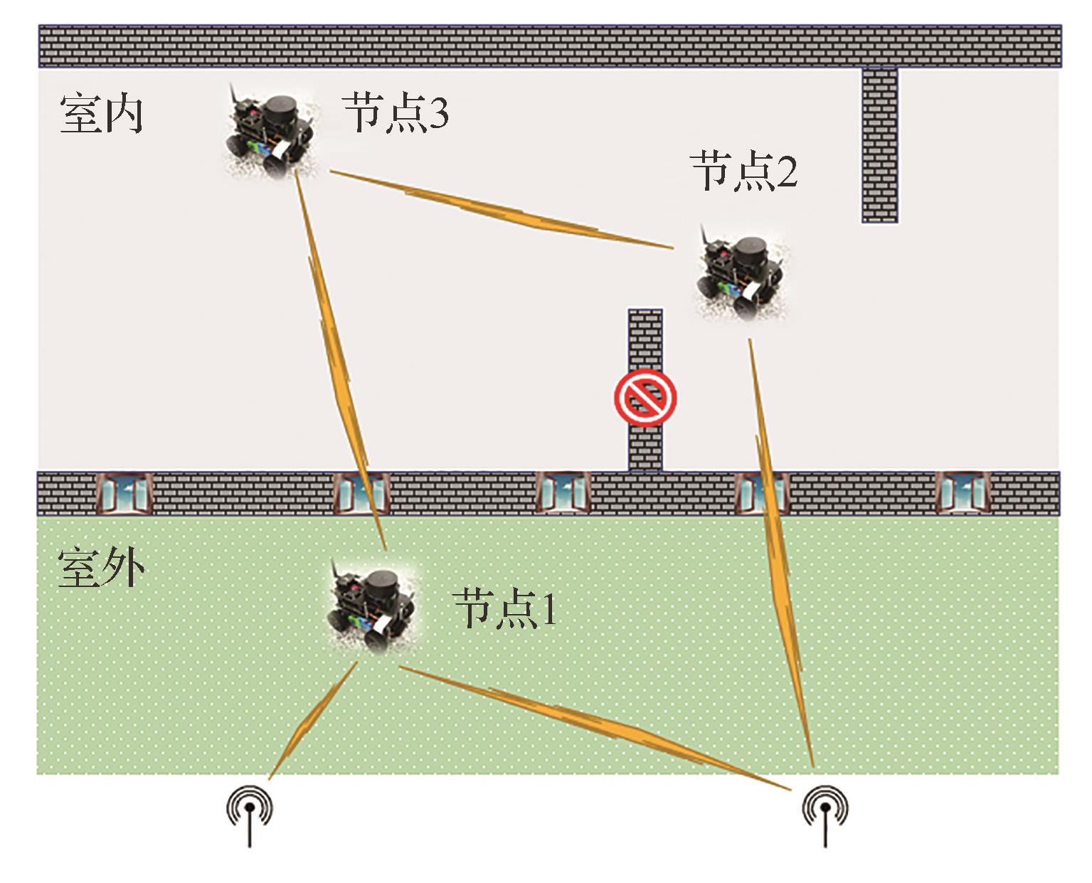
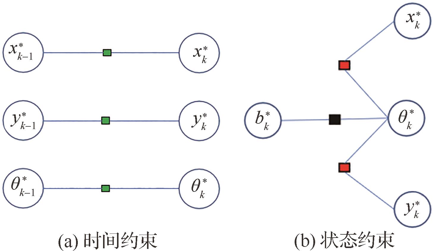
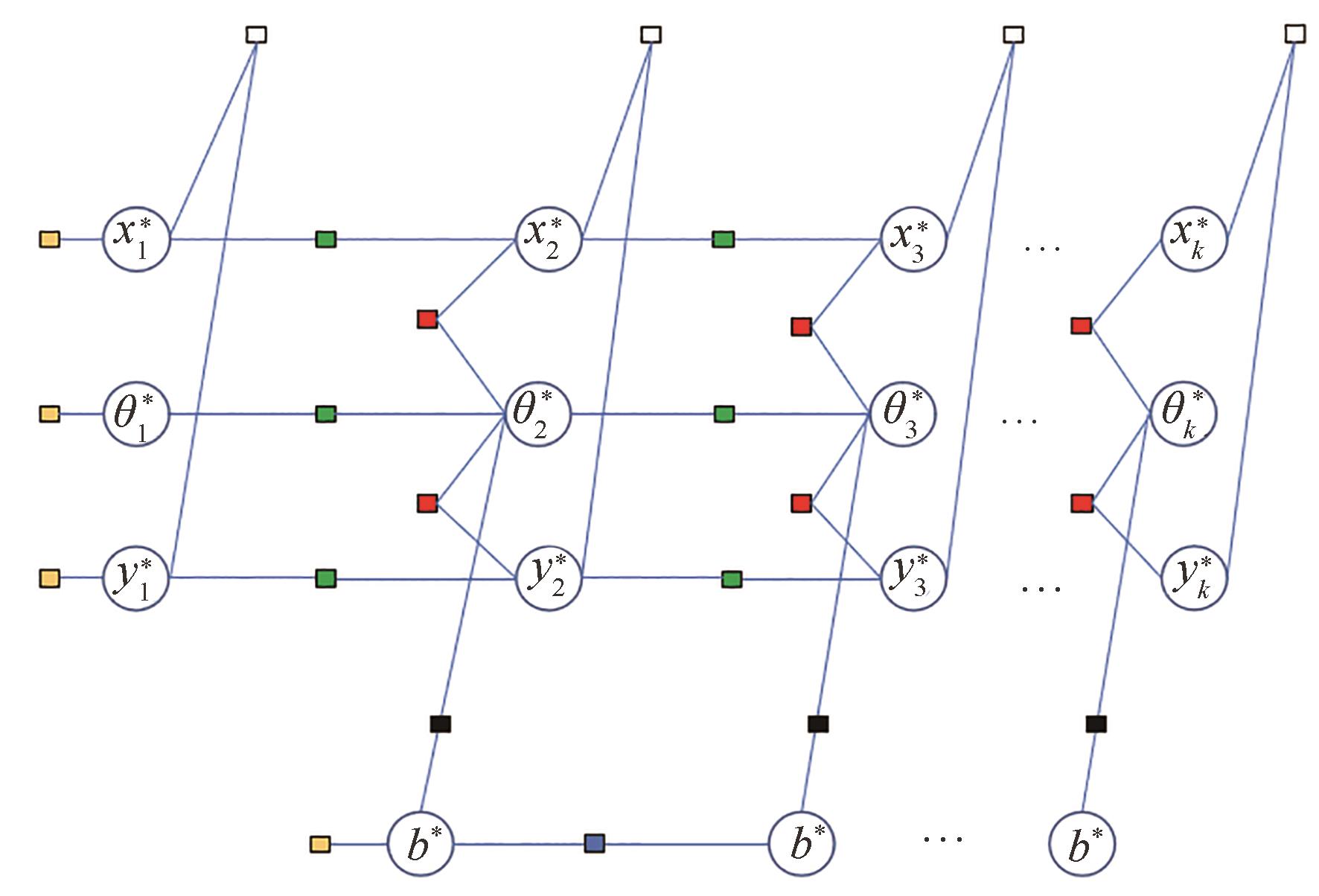
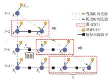
| 1 |
叶结松, 龚柏春, 李爽, 等. 基于相对方位信息和单间距测量的多智能体编队协同控制[J]. 航空学报, 2021, 42(7): 324610.
|
|
YE J S, GONG B C, LI S, et al. Multi-agent formation cooperative control using relative bearing information and single-spacing measurement[J]. Acta Aeronautica et Astronautica Sinica, 2021, 42(7): 324610 (in Chinese).
|
| 2 |
张普, 薛惠锋, 高山. 基于分布式自适应的多智能体容错一致性控制[J]. 航空学报, 2020, 41(3): 323539.
|
|
ZHANG P, XUE H F, GAO S. Distributed adaptive fault-tolerance consensus control for multi-agent system[J]. Acta Aeronautica et Astronautica Sinica, 2020, 41(3): 323539 (in Chinese).
|
| 3 |
王巍, 邢朝洋, 冯文帅. 自主导航技术发展现状与趋势[J]. 航空学报, 2021, 42(11): 525049.
|
|
WANG W, XING C Y, FENG W S. State of the art and perspectives of autonomous navigation technology[J]. Acta Aeronautica et Astronautica Sinica, 2021, 42(11): 525049 (in Chinese).
|
| 4 |
CUI Q M, ZHANG X F. Research analysis of wireless localization with insufficient resources for next-generation mobile communication networks[J]. International Journal of Communication Systems, 2013, 26(9): 1206-1226.
|
| 5 |
许晓伟, 赖际舟, 吕品, 等. 多无人机协同导航技术研究现状及进展[J]. 导航定位与授时, 2017, 4(4): 1-9.
|
|
XU X W, LAI J Z, LV P, et al. A literature review on the research status and progress of cooperative navigation technology for multiple UAVs[J]. Navigation Positioning and Timing, 2017, 4(4): 1-9 (in Chinese).
|
| 6 |
谢启龙, 宋龙, 鲁浩, 等. 协同导航技术研究综述[J]. 航空兵器, 2019, 26(4): 23-30.
|
|
XIE Q L, SONG L, LU H, et al. Review of collaborative navigation technology[J]. Aero Weaponry, 2019, 26(4): 23-30 (in Chinese).
|
| 7 |
陈明星, 熊智, 刘建业, 等. 基于因子图的无人机集群分布式协同导航方法[J]. 中国惯性技术学报, 2020, 28(4): 456-461.
|
|
CHEN M X, XIONG Z, LIU J Y, et al. Distributed cooperative navigation method of UAV swarm based on factor graph[J]. Journal of Chinese Inertial Technology, 2020, 28(4): 456-461 (in Chinese).
|
| 8 |
FAN S W, ZHANG Y, HAO Q, et al. Cooperative positioning for multi-AUVs based on factor graph and maximum correntropy[J]. IEEE Access, 2019, 7: 153327-153337.
|
| 9 |
闫敬, 张立, 罗小元, 等. 异步时钟下基于信息物理融合的水下潜器协同定位算法[J]. 自动化学报, 2019, 45(4): 739-748.
|
|
YAN J, ZHANG L, LUO X Y, et al. Cyber-physical cooperative localization algorithms for underwater vehicle with asynchronous time clock[J]. Acta Automatica Sinica, 2019, 45(4): 739-748 (in Chinese).
|
| 10 |
GUO K X, QIU Z R, MENG W, et al. Ultra-wideband based cooperative relative localization algorithm and experiments for multiple unmanned aerial vehicles in GPS denied environments[J]. International Journal of Micro Air Vehicles, 2017, 9(3): 169-186.
|
| 11 |
GUO K X, LI X X, XIE L H. Ultra-wideband and odometry-based cooperative relative localization with application to multi-UAV formation control[J]. IEEE Transactions on Cybernetics, 2020, 50(6): 2590-2603.
|
| 12 |
GUO K X, HAN D, XIE L H. Range-based cooperative localization with single landmark[C]∥2017 13th IEEE International Conference on Control & Automation (ICCA). Piscataway: IEEE Press, 2017: 588-593.
|
| 13 |
韩飞, 刘付成, 王兆龙, 等. 空间多机器人协同的多视线仅测角相对导航[J]. 航空学报, 2021, 42(1): 524174.
|
|
HAN F, LIU F C, WANG Z L, et al. Multiple line-of-sight angles-only relative navigation by multiple collaborative space robots[J]. Acta Aeronautica et Astronautica Sinica, 2021, 42(1): 524174 (in Chinese).
|
| 14 |
罗子岩, 陈帅, 王国栋, 等. 多源融合导航系统的因子图算法综述[J]. 导航与控制, 2021, 20(3): 9-16.
|
|
LUO Z Y, CHEN S, WANG G D, et al. A survey of factor graph algorithms for multi-source fusion navigation system[J]. Navigation and Control, 2021, 20(3): 9-16 (in Chinese).
|
| 15 |
DELLAERT F, KAESS M. Factor graphs for robot perception[M]. Hanover: Now Publishers, 2017
|
| 16 |
QIN T, LI P L, SHEN S J. VINS-mono: A robust and versatile monocular visual-inertial state estimator[J]. IEEE Transactions on Robotics, 2018, 34(4): 1004-1020.
|
| 17 |
CAMPOS C, ELVIRA R, RODRÍGUEZ J J G, et al. ORB-SLAM3: An accurate open-source library for visual, visual-inertial, and multimap SLAM[J]. IEEE Transactions on Robotics, 2021, 37(6): 1874-1890.
|
| 18 |
XU H, WANG L Q, ZHANG Y C, et al. Decentralized visual-inertial-UWB fusion for relative state estimation of aerial swarm[C]∥ 2020 IEEE International Conference on Robotics and Automation (ICRA). Piscataway: IEEE Press, 2020: 8776-8782.
|
| 19 |
CAO Y J, BELTRAME G. VIR-SLAM: Visual, inertial, and ranging SLAM for single and multi-robot systems[J]. Autonomous Robots, 2021, 45(6): 905-917.
|
| 20 |
SHEN H, ZONG Q, HANCHEN L U, et al. A distributed approach for lidar-based relative state estimation of multi-UAV in GPS-denied environments[J]. Chinese Journal of Aeronautics, 2022, 35(1): 59-69.
|
| 21 |
SASKA M, BACA T, THOMAS J, et al. System for deployment of groups of unmanned micro aerial vehicles in GPS-denied environments using onboard visual relative localization[J]. Autonomous Robots, 2017, 41(4): 919-944.
|
| 22 |
WALTER V, STAUB N, FRANCHI A, et al. UVDAR system for visual relative localization with application to leader-follower formations of multirotor UAVs[J]. IEEE Robotics and Automation Letters, 2019, 4(3): 2637-2644.
|
| 23 |
SCHMUCK P, CHLI M. CCM-SLAM: Robust and efficient centralized collaborative monocular simultaneous localization and mapping for robotic teams[J]. Journal of Field Robotics, 2019, 36(4): 763-781.
|
 ), 李健, 杨功流