Acta Aeronautica et Astronautica Sinica ›› 2026, Vol. 47 ›› Issue (10): 632581.doi: 10.7527/S1000-6893.2025.32581
• Special Issue: Intelligent Processing and Analysis of Aerospace Remote Sensing Images • Previous Articles
Zhiyang LIU1, Quanwei LIU2, Yuxiang ZHANG3, Yanni DONG1( )
)
Received:2025-07-16
Revised:2025-08-18
Accepted:2025-09-16
Online:2025-10-10
Published:2025-09-24
Contact:
Yanni DONG
E-mail:dongyanni@whu.edu.cn
Supported by:CLC Number:
Zhiyang LIU, Quanwei LIU, Yuxiang ZHANG, Yanni DONG. Multi-modal marine oil spill detection via airborne hyperspectral image and satellite-borne synthetic aperture radar image fusion in aerospace remote sensing[J]. Acta Aeronautica et Astronautica Sinica, 2026, 47(10): 632581.
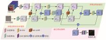
Fig.1
Overall architecture of multi-modal remote sensing semantic segmentation model for marine oil spill detection

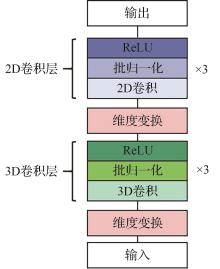
Fig.2
3D convolution module structure
Fig.3
MCASPP module structure
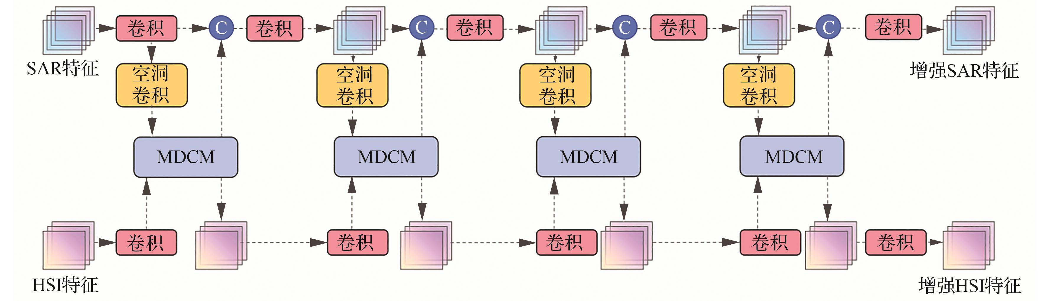
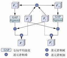
Fig.4
MDCM structure
Fig.5
DLEM structure
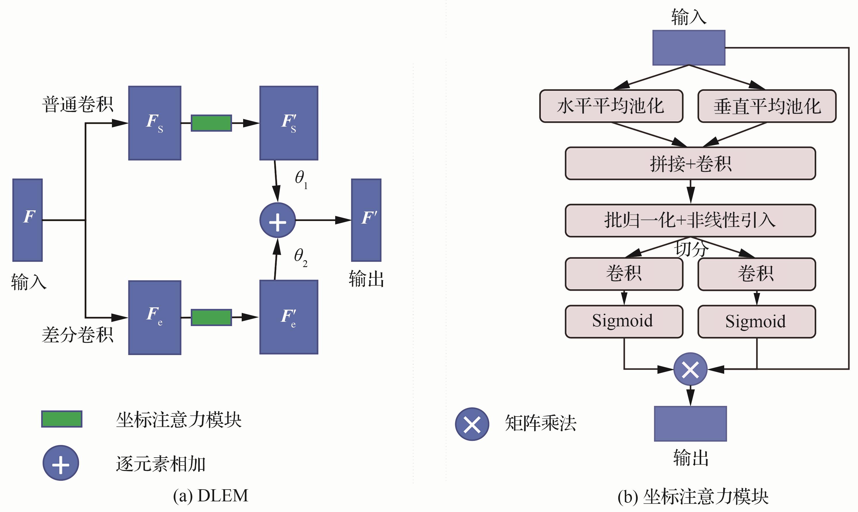
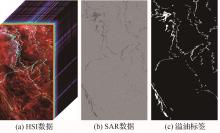
Fig.6
Raw data example
Table 1
Results of ablation experiments
| 3D卷积模块 | MCASPP模块 | DLEM | OA/% | Kappa系数/% | mIoU/% | F1分数/% |
|---|---|---|---|---|---|---|
| × | × | × | 98.70 | 89.35 | 90.25 | 90.04 |
| √ | × | × | 99.13 | 93.66 | 93.99 | 94.13 |
| × | √ | × | 99.58 | 95.85 | 96.00 | 96.07 |
| × | × | √ | 98.83 | 91.23 | 91.85 | 91.86 |
| √ | √ | × | 99.73** | 97.86** | 97.90** | 98.01** |
| √ | × | √ | 99.47 | 95.77 | 95.92 | 96.06 |
| × | √ | √ | 99.65 | 97.28 | 97.34 | 97.47 |
| √ | √ | √ | 99.93* | 99.43* | 99.41* | 99.47* |
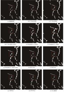
Fig.7
Visualization of experimental results in Region 1
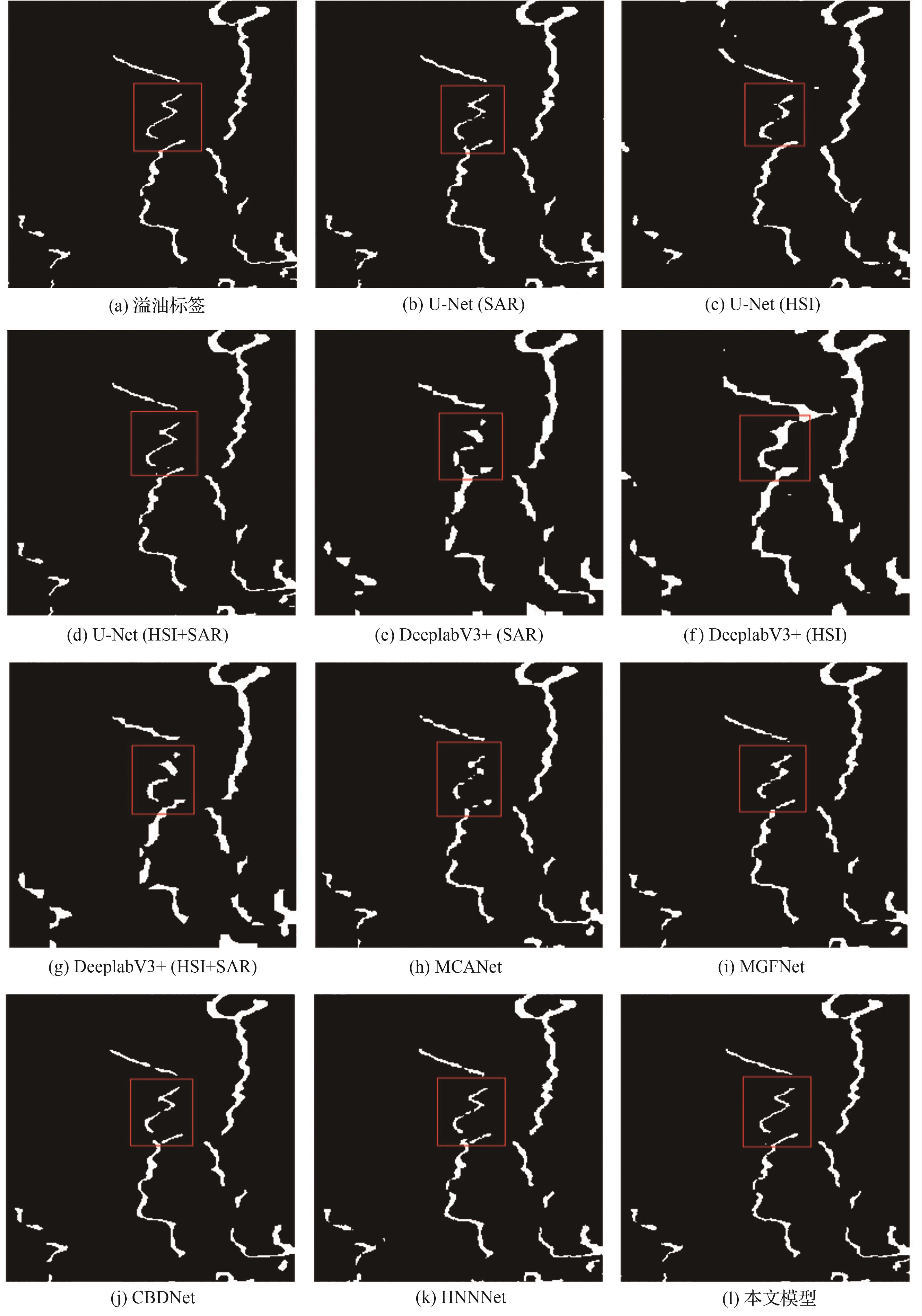
Fig.8
Visualization of experimental results in Region 2
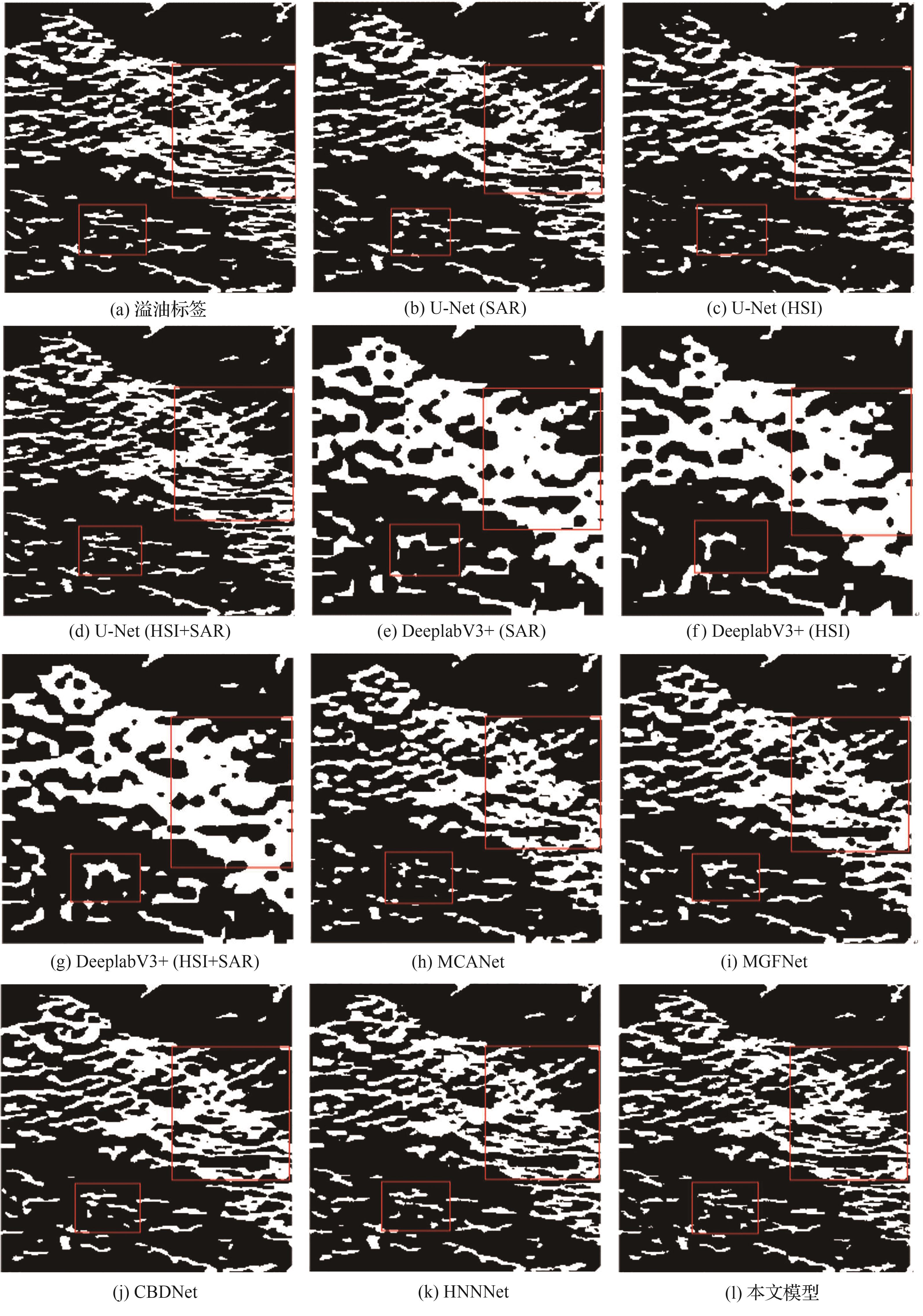
Table 2
Results of comparison experiments
| 模型 | OA/% | Kappa系数/% | mIoU/% | Recall/% | Precision/% | F1分数/% |
|---|---|---|---|---|---|---|
| U-Net (SAR) | 99.60** | 96.51 | 96.62 | 97.92 | 95.55** | 96.72 |
| U-Net (HSI) | 97.55 | 80.93 | 83.61 | 93.32 | 73.49 | 82.23 |
| U-Net (HSI+SAR) | 99.24 | 93.18 | 93.57 | 98.51 | 89.12 | 93.58 |
| DeeplabV3+ (SAR) | 97.43 | 81.89 | 84.28 | 95.82 | 73.60 | 83.25 |
| DeeplabV3+ (HSI) | 96.73 | 75.52 | 79.72 | 93.26 | 65.89 | 77.22 |
| DeeplabV3+ (HSI+SAR) | 98.12 | 84.84 | 86.59 | 96.68 | 77.18 | 85.83 |
| MCANet (HSI+SAR) | 99.09 | 93.57 | 93.91 | 99.03 | 89.57 | 94.06 |
| MGFNet (HSI+SAR) | 99.15 | 92.92 | 93.34 | 98.51 | 88.57 | 93.37 |
| CBDNet (SAR) | 99.29 | 94.62 | 94.86 | 98.62 | 91.63 | 95.00 |
| HNNNet (SAR) | 99.60** | 97.04** | 97.11** | 99.37** | 95.22 | 97.25** |
| 本文模型(HSI+SAR) | 99.93* | 99.43* | 99.41* | 99.61* | 99.33* | 99.47* |
Table 3
Comparison of model efficiency and performance
| 模型 | Params/M | FLOPs/G | FPS | Kappa系数/% | mIoU/% |
|---|---|---|---|---|---|
| U-Net (HSI+SAR) | 31.07 | 55.50 | 67.48 | 93.18 | 93.57 |
| DeeplabV3+ (HSI+SAR) | 39.69 | 41.95 | 110.13 | 84.84 | 86.59 |
| MCANet (HSI+SAR) | 73.14 | 90.31 | 96.10 | 93.57 | 93.91 |
| MGFNet (HSI+SAR) | 109.56 | 33.91 | 16.91 | 92.92 | 93.34 |
| CBDNet (SAR) | 31.45 | 8.40 | 122.51 | 94.62 | 94.86 |
| HNNNet (SAR) | 14.72 | 31.34 | 257.53 | 97.04 | 97.11 |
| 本文模型(HSI+SAR) | 13.81 | 255.45 | 26.08 | 99.43 | 99.41 |
| [1] | 李德仁. 论21世纪遥感与GIS的发展[J]. 武汉大学学报(信息科学版), 2003, 28(2): 127-131. |
| LI D R. Towards the development of remote sensing and GIS in the 21st century[J]. Geomatics and Information Science of Wuhan University, 2003, 28(2): 127-131 (in Chinese). | |
| [2] | 李德仁, 张良培, 夏桂松. 遥感大数据自动分析与数据挖掘[J]. 测绘学报, 2014, 43(12): 1211-1216. |
| LI D R, ZHANG L P, XIA G S. Automatic analysis and mining of remote sensing big data[J]. Acta Geodaetica et Cartographica Sinica, 2014, 43(12): 1211-1216 (in Chinese). | |
| [3] | BARTSCH N, GRUNER K, KEYDEL W, et al. Contributions to oil-spill detection and analysis with radar and microwave radiometry: Results of the Archimedes Ⅱ campaign[J]. IEEE Transactions on Geoscience and Remote Sensing, 1987, 25(6): 677-690. |
| [4] | SOLBERG A H S, STORVIK G, SOLBERG R, et al. Automatic detection of oil spills in ERS SAR images[J]. IEEE Transactions on Geoscience and Remote Sensing, 1999, 37(4): 1916-1924. |
| [5] | STRINGER W J, DEAN K G, GURITZ R M, et al. Detection of petroleum spilled from the MV exxon valdez[J]. International Journal of Remote Sensing, 1992, 13(5): 799-824. |
| [6] | LI Z, CHEN L, ZHANG B, et al. SAR image oil spill detection based on maximum entropy threshold segmentation[J]. Signal Process, 2019, 35: 1111-1117. |
| [7] | BASS F G, PUZENKO S A. Detection of oil spills on the sea using radar measurements[J]. Journal of Electromagnetic Waves and Applications, 1994, 8(7): 859-870. |
| [8] | SINGH K P. Monitoring of oil spills using airborne and spaceborne sensors[J]. Advances in Space Research, 1995, 15(11): 101-110. |
| [9] | SLOGGETT D R. An automated approach to the detection of oil spills in satellite-based SAR imagery[J]. The Determination of Geophysical Parameters from Space, 1996: 103. |
| [10] | KUBAT M, HOLTE R C, MATWIN S. Machine learning for the detection of oil spills in satellite radar images[J]. Machine Learning, 1998, 30(2): 195-215. |
| [11] | CALABRESI G, DEL FRATE F, LICHTENEGGER J, et al. Neural networks for the oil spill detection using ERS-SAR data[C]∥ IEEE 1999 International Geoscience and Remote Sensing Symposium. Piscataway: IEEE Press, 2002: 215-217. |
| [12] | RAMALHO G L B, MEDEIROS F N S. Using boosting to improve oil spill detection in SAR images[C]∥ 18th International Conference on Pattern Recognition (ICPR’06). Piscataway: IEEE Press, 2006: 1066-1069. |
| [13] | LOPEZ L, MOCTEZUMA M, PARMIGGIANI F. Contextual approach for oil spill detection in SAR images using image fusion and Markov random fields[C]∥ 49th IEEE International Midwest Symposium on Circuits and Systems. Piscataway: IEEE Press, 2007: 137-139. |
| [14] | SHI L J, ZHANG X D, SEIELSTAD G, et al. Oil spill detection by MODIS images using fuzzy cluster and texture feature extraction[C]∥ OCEANS 2007—Europe Conference. Piscataway: IEEE Press, 2007: 1-5. |
| [15] | WARDAYA P D. Support vector machine as a binary classifier for automated object detection in remotely sensed data[C]∥ IOP Conference Series: Earth and Environmental Science. United Kingdom: IOP Publishing, 2014. |
| [16] | GUO H, WU D N, AN J B. Discrimination of oil slicks and lookalikes in polarimetric SAR images using CNN[J]. Sensors, 2017, 17(8): 1837. |
| [17] | TEMITOPE YEKEEN S, BALOGUN A L, WAN YUSOF K B. A novel deep learning instance segmentation model for automated marine oil spill detection[J]. ISPRS Journal of Photogrammetry and Remote Sensing, 2020, 167: 190-200. |
| [18] | YANG J F, MA Y, HU Y B, et al. Decision fusion of deep learning and shallow learning for marine oil spill detection[J]. Remote Sensing, 2022, 14(3): 666. |
| [19] | WANG B, SHAO Q F, SONG D M, et al. A spectral-spatial features integrated network for hyperspectral detection of marine oil spill[J]. Remote Sensing, 2021, 13(8): 1568. |
| [20] | LI J Y, MA Y, JI Y G, et al. SR-SqueezeNet: A lightweight hyperspectral identification model for oil spills based on smoothed activation functions[J]. Marine Pollution Bulletin, 2025, 211: 117365. |
| [21] | 袁静文, 武辰, 杜博, 等. 高分五号高光谱遥感影像的城市土地利用景观格局分析[J]. 遥感学报, 2020, 24(4): 465-478. |
| YUAN J W, WU C, DU B, et al. Analysis of landscape pattern on urban land use based on GF-5 hyperspectral data[J]. Journal of Remote Sensing, 2020, 24(4): 465-478 (in Chinese). | |
| [22] | 王子玲, 熊振宇, 杨璐铖, 等. AIS和光学遥感图像引导的星载SAR舰船目标识别网络[J]. 航空学报, 2024, 45(2): 328672. |
| WANG Z L, XIONG Z Y, YANG L C, et al. Spaceborne SAR ship target recognition network guided by AIS and optical remote sensing images[J]. Acta Aeronautica et Astronautica Sinica, 2024, 45(2): 328672 (in Chinese). | |
| [23] | ESPEDAL H A, JOHANNESSEN O M. Detection of oil spills near offshore installations using synthetic aperture radar (SAR)[J]. International Journal of Remote Sensing, 2000, 21(11): 2141-2144. |
| [24] | TOPOUZELIS K, KARATHANASSI V, PAVLAKIS P, et al. Detection and discrimination between oil spills and look-alike phenomena through neural networks[J]. ISPRS Journal of Photogrammetry and Remote Sensing, 2007, 62(4): 264-270. |
| [25] | 何友, 刘瑜, 李耀文, 等. 多源信息融合发展及展望[J]. 航空学报, 2025, 46(6): 531672. |
| HE Y, LIU Y, LI Y W, et al. Development and prospects of multisource information fusion[J]. Acta Aeronautica et Astronautica Sinica, 2025, 46(6): 531672 (in Chinese). | |
| [26] | LI X, ZHANG G, CUI H, et al. MCANet: A joint semantic segmentation framework of optical and SAR images for land use classification[J]. International Journal of Applied Earth Observation and Geoinformation, 2022, 106: 102638. |
| [27] | HONG D F, ZHANG B, LI H, et al. Cross-city matters: A multimodal remote sensing benchmark dataset for cross-city semantic segmentation using high-resolution domain adaptation networks[J]. Remote Sensing of Environment, 2023, 299: 113856. |
| [28] | 郑远驰. 基于多模态融合的遥感图像分割方法研究[D]. 成都: 电子科技大学, 2024: 6. |
| ZHENG Y C. Research on remote sensing image segmentation method based on multimodal fusion[D]. Chengdu: University of Electronic Science and Technology of China, 2024: 6 (in Chinese). | |
| [29] | LIU Q W, HUANG T, DONG Y N, et al. Enhancing oil spill detection with controlled random sampling: A multimodal fusion approach using SAR and HSI imagery[J]. Remote Sensing Applications: Society and Environment, 2025, 38: 101601. |
| [30] | YANG M K, YU K, ZHANG C, et al. Denseaspp for semantic segmentation in street scenes[C]∥ Proceedings of the IEEE Conference on Computer Vision and Pattern Recognition. Piscataway: IEEE Press, 2018: 3684-3692. |
| [31] | ZHAO W Q, ZHAO Z H, XU M F, et al. Differential multimodal fusion algorithm for remote sensing object detection through multi-branch feature extraction[J]. Expert Systems with Applications, 2025, 265: 125826. |
| [32] | HOU Q B, ZHOU D Q, FENG J S. Coordinate attention for efficient mobile network design[C]∥ Proceedings of the IEEE/CVF Conference on Computer Vision and Pattern Recognition. Piscataway: IEEE Press, 2021: 13713-13722. |
| [33] | YIN Z Y, WANG Z S, FAN C, et al. Edge detection via fusion difference convolution[J]. Sensors, 2023, 23(15): 6883. |
| [34] | DUAN P H, KANG X D, GHAMISI P, et al. Hyperspectral remote sensing benchmark database for oil spill detection with an isolation forest-guided unsupervised detector[J]. IEEE Transactions on Geoscience and Remote Sensing, 2023, 61: 5509711. |
| [35] | RONNEBERGER O, FISCHER P, BROX T. U-Net: Convolutional networks for biomedical image segmentation[C]∥ International Conference on Medical Image Computing and Computer-Assisted Intervention. Cham: Springer International Publishing, 2015: 234-241. |
| [36] | CHEN L C, ZHU Y K, PAPANDREOU G, et al. Encoder-decoder with atrous separable convolution for semantic image segmentation[C]∥ Proceedings of the European Conference on Computer Vision (ECCV). Berlin: Springer, 2018: 801-818. |
| [37] | WEI K, DAI J K, HONG D F, et al. MGFNet: An MLP-dominated gated fusion network for semantic segmentation of high-resolution multi-modal remote sensing images[J]. International Journal of Applied Earth Observation and Geoinformation, 2024, 135: 104241. |
| [38] | ZHU Q Q, ZHANG Y N, LI Z Q, et al. Oil spill contextual and boundary-supervised detection network based on marine SAR images[J]. IEEE Transactions on Geoscience and Remote Sensing, 2022, 60: 5213910. |
| [39] | XIE S N, TU Z W. Holistically-nested edge detection[C]∥ Proceedings of the IEEE International Conference on Computer Vision. Piscataway: IEEE Press, 2015: 1395-1403. |
| [1] | Yuzhuo MA, Kan REN, Tao LI, Qian CHEN. Improving remote sensing image semantic segmentation based on distance loss [J]. Acta Aeronautica et Astronautica Sinica, 2026, 47(8): 332780-332780. |
| [2] | Ao SUN, Fang XU, Shuguo JIANG, Wen YANG, Guisong XIA. A semantic segmentation method enhanced by multimodal collaboration in remote sensing foundation models [J]. Acta Aeronautica et Astronautica Sinica, 2026, 47(10): 532910-532910. |
| [3] | Xu TANG, Feng GU, Jingjing MA, Xiangrong ZHANG. Hyperspectral-LiDAR joint classification method based on vision-language pre-trained models [J]. Acta Aeronautica et Astronautica Sinica, 2026, 47(10): 139-158. |
| [4] | Runmin CONG, Haoyan SUN, Yuxuan LUO, Hao FANG. Generalized few-shot segmentation for remote sensing image based on class relation mining [J]. Acta Aeronautica et Astronautica Sinica, 2025, 46(23): 631694-631694. |
| [5] | Jiaxin LI, Shuaishuai LYU, Yezi WANG, Yu YANG, Ziyue LI. Transformer-based intelligent tracking method of aviation structure surface cracks [J]. Acta Aeronautica et Astronautica Sinica, 2025, 46(21): 532355-532355. |
| [6] | Xudong LUO, Yiquan WU, Jinlin CHEN. Research progress on deep learning methods for object detection and semantic segmentation in UAV aerial images [J]. Acta Aeronautica et Astronautica Sinica, 2024, 45(6): 28822-028822. |
| [7] | Xin SU, Runcheng GUAN, Qiao WANG, Weizheng YUAN, Xianglian LYU, Yang HE. Ice area and thickness detection method based on deep learning [J]. Acta Aeronautica et Astronautica Sinica, 2023, 44(S2): 729283-729283. |
| [8] | Xiaohang LI, Jianjiang ZHOU. Multi⁃scale modality fusion network based on adaptive memory length [J]. Acta Aeronautica et Astronautica Sinica, 2023, 44(22): 628977-628977. |
| Viewed | ||||||
|
Full text |
|
|||||
|
Abstract |
|
|||||
Address: No.238, Baiyan Buiding, Beisihuan Zhonglu Road, Haidian District, Beijing, China
Postal code : 100083
E-mail:hkxb@buaa.edu.cn
Total visits: 6658907 Today visits: 1341All copyright © editorial office of Chinese Journal of Aeronautics
All copyright © editorial office of Chinese Journal of Aeronautics
Total visits: 6658907 Today visits: 1341