Acta Aeronautica et Astronautica Sinica ›› 2026, Vol. 47 ›› Issue (10): 532599.doi: 10.7527/S1000-6893.2025.32599
• Special Issue: Intelligent Processing and Analysis of Aerospace Remote Sensing Images • Previous Articles
Guangyu LU, Bowen CHEN, Keyan CHEN, Zhengxia ZOU, Zhenwei SHI( )
)
Received:2025-07-21
Revised:2025-08-21
Accepted:2025-10-20
Online:2025-10-28
Published:2025-10-24
Contact:
Zhenwei SHI
E-mail:shizhenwei@buaa.edu.cn
Supported by:CLC Number:
Guangyu LU, Bowen CHEN, Keyan CHEN, Zhengxia ZOU, Zhenwei SHI. Spaceborne remote sensing image object detection based on mixture of experts model[J]. Acta Aeronautica et Astronautica Sinica, 2026, 47(10): 532599.
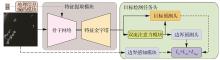
Fig.1
Network architecture of proposed model
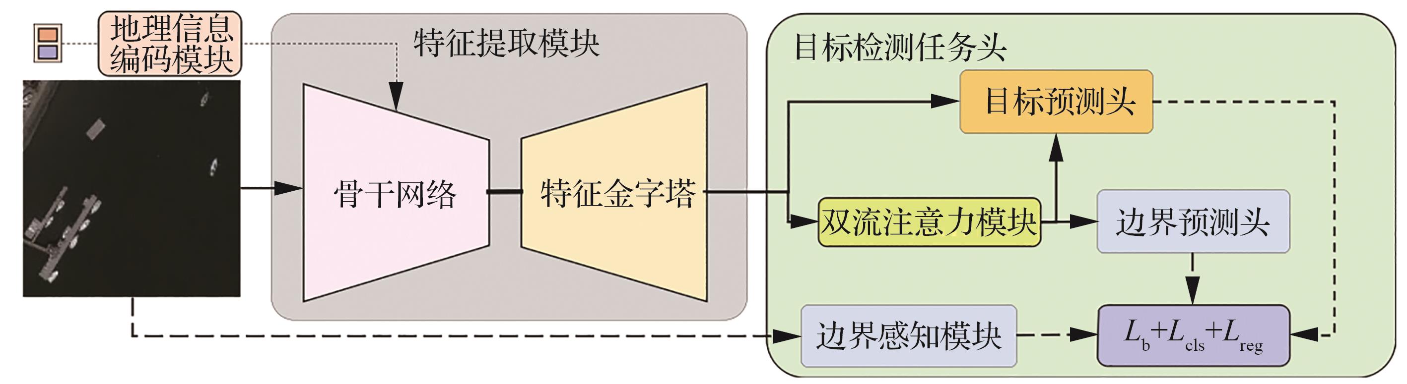
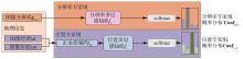
Fig.2
Geographic information coding module structure
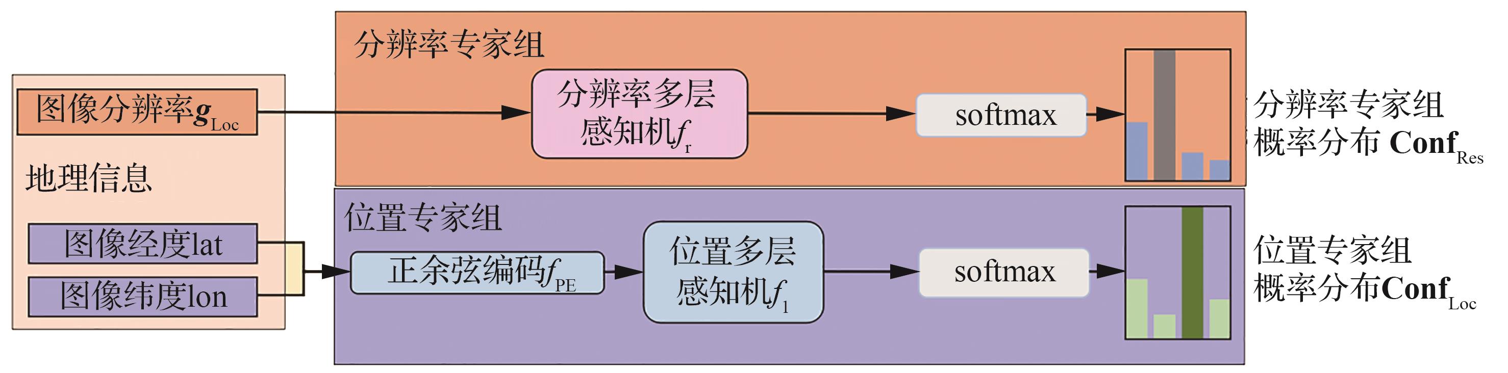
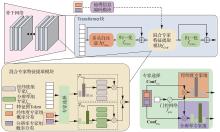
Fig.3
Structure of feature extraction module
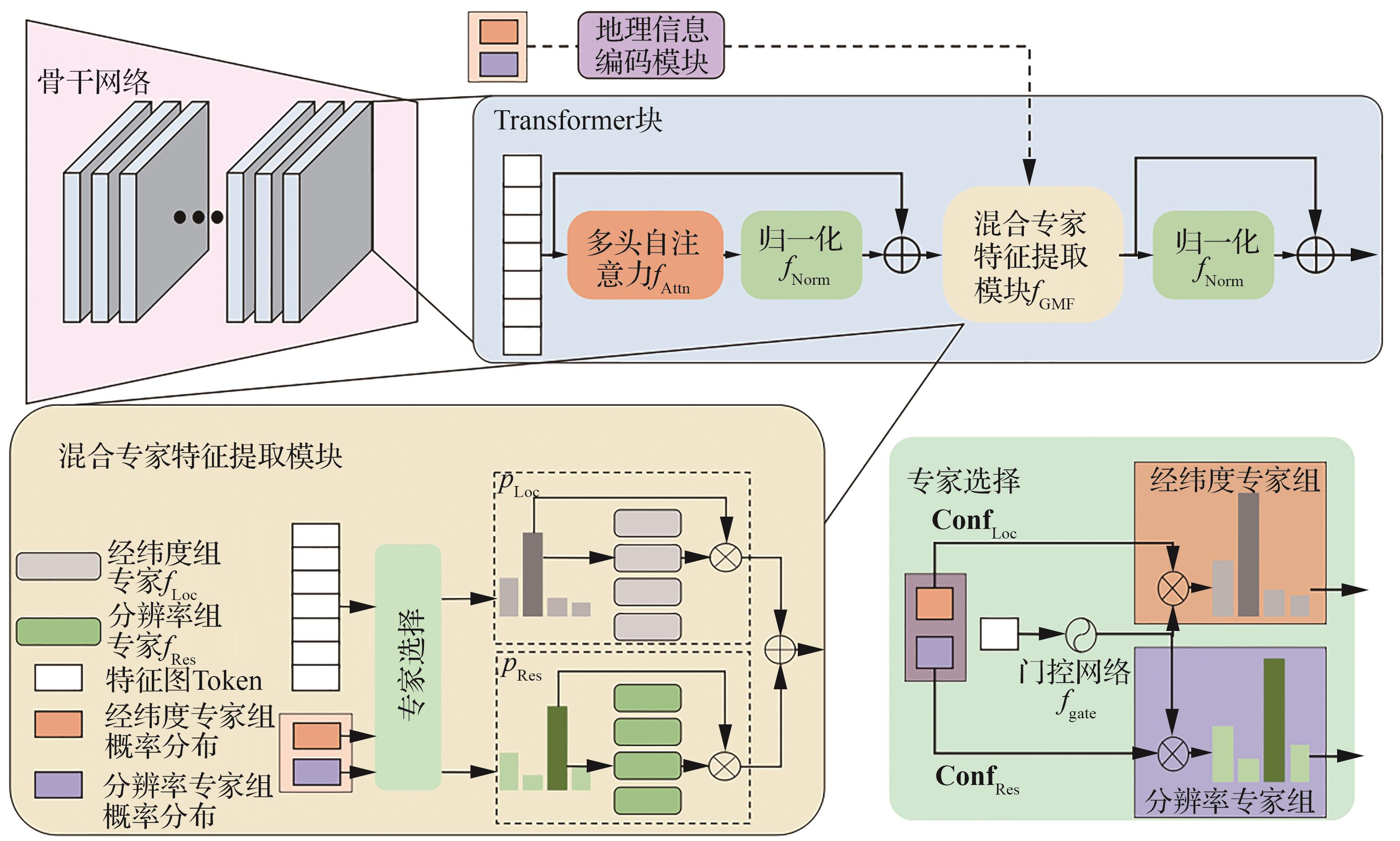
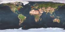
Fig.4
Distribution of data collection area locations

Table 1
Number distribution of images of different ports in GISD
| 港口编号 | 港口名称 | 纬度坐标 | 经度坐标 | 数据集总数 |
|---|---|---|---|---|
| 1 | Ellefsen Harbor | 60.733 333°S | 45.033 333°W | 21 |
| 2 | Surabaya | 7.2°S | 112.733 333°E | 197 |
| 3 | Panjang | 5.466 667°S | 105.316 667°E | 124 |
| 4 | Aksaz Limani | 36.833 333°N | 28.383 333°E | 44 |
| 5 | Pyeongtaek Hang | 37°N | 126.8°E | 127 |
| 6 | Lavrio | 37.7°N | 24.066 667°E | 271 |
| 7 | Annapolis | 38.983 333°N | 76.483 333°W | 7 |
| 8 | Baltimore | 39.266 667°N | 76.583 333°W | 86 |
| 9 | Gemlik | 40.416 667°N | 29.116 667°E | 50 |
| 10 | Port Reading | 40.566 667°N | 74.233 333°W | 52 |
| 11 | Salerno | 40.666 667°N | 14.75°E | 51 |
| 12 | Brooklyn | 40.666 667°N | 74.016 667°W | 197 |
| 13 | Midland | 44.75°N | 79.916 667°W | 122 |
| 14 | Carillon | 45.566 667°N | 74.366 667°W | 66 |
| 15 | Mykolayiv | 46.95°N | 31.983 333°E | 71 |
| 16 | Maassluis | 51.916 667°N | 4.25°E | 129 |
| 17 | Bella | 52.166 667°N | 128.15°W | 213 |
| 18 | Bird Port | 51.566 667°N | 2.966 667°W | 17 |
| 19 | Pevek | 69.716 667°N | 170.3°E | 15 |

Fig.5
Distribution of image quantity under different resolutions of GISD
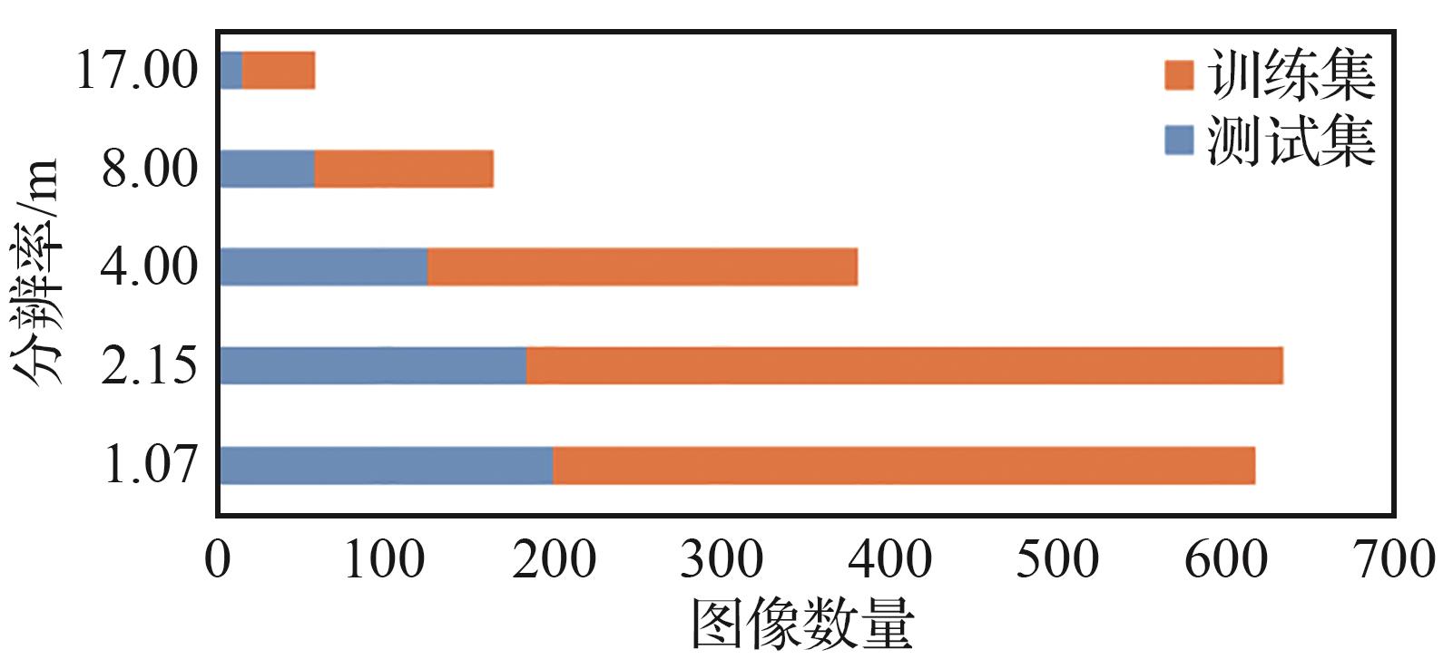

Fig.6
Distribution of number of ship targets with different sizes of GISD
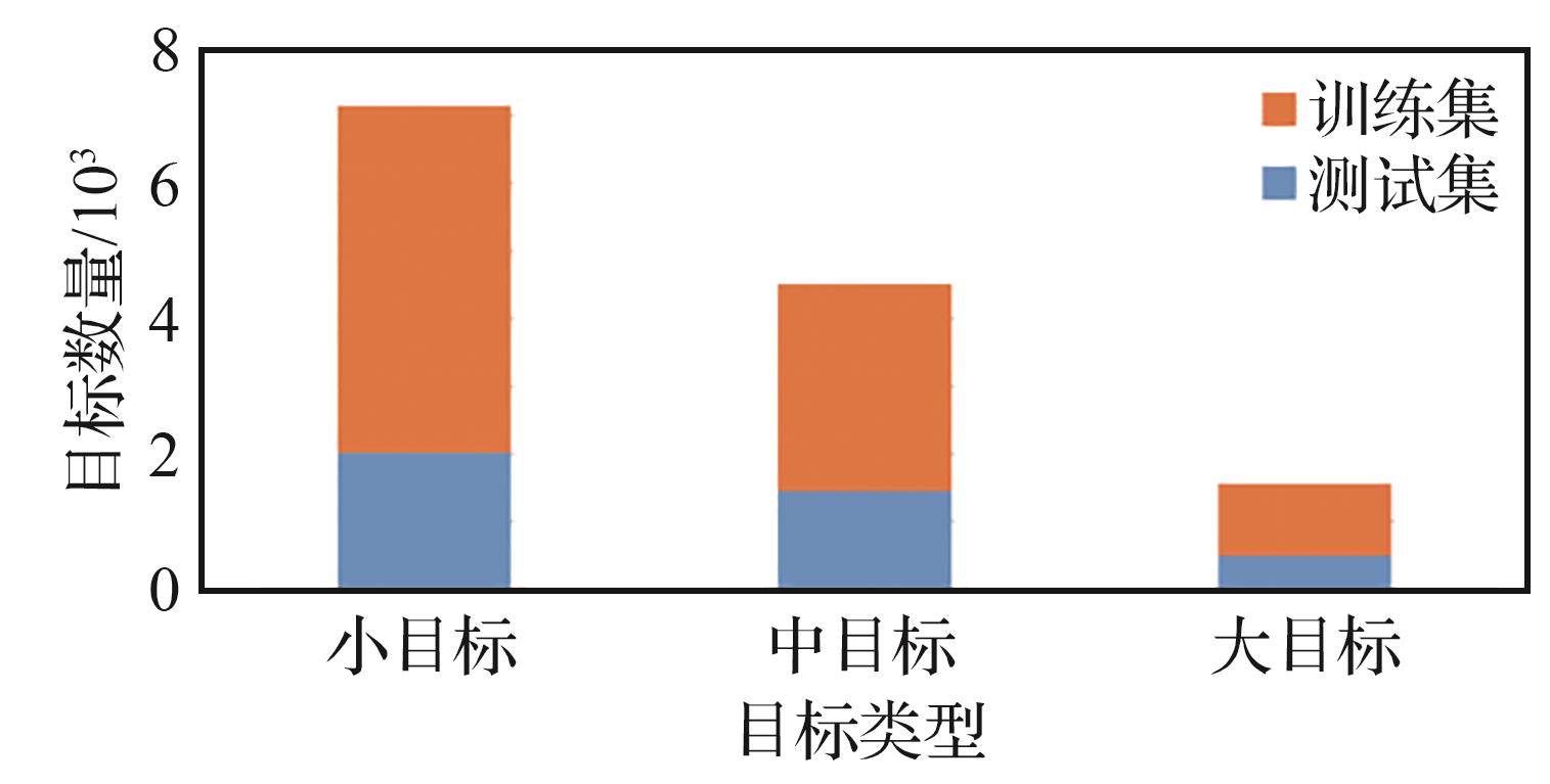
Table 2
Ablation experiments
| 网络模型 | AP | AP50 | AP75 | APs | APm | APl |
|---|---|---|---|---|---|---|
| 基准模型 | 0.393 | 0.768 | 0.360 | 0.280 | 0.458 | 0.604 |
| MoE | 0.396 | 0.770 | 0.366 | 0.276 | 0.462 | 0.624 |
| MoE+L | 0.416 | 0.786 | 0.401 | 0.263 | 0.498 | 0.637 |
| 本文模型 | 0.428 | 0.806 | 0.408 | 0.268 | 0.537 | 0.662 |
Table 3
Boundary loss weight experiments
| 损失权重 | AP | AP50 | AP75 | APs | APm | APl |
|---|---|---|---|---|---|---|
| 0 | 0.387 | 0.763 | 0.353 | 0.233 | 0.496 | 0.613 |
| 0.1 | 0.401 | 0.783 | 0.379 | 0.238 | 0.511 | 0.635 |
| 0.5 | 0.428 | 0.806 | 0.408 | 0.268 | 0.537 | 0.662 |
| 1.0 | 0.423 | 0.794 | 0.401 | 0.253 | 0.536 | 0.674 |
| 5.0 | 0.411 | 0.796 | 0.377 | 0.255 | 0.520 | 0.630 |
Table 4
Expert quantity selection experiments
| 专家数量 | AP | AP50 | AP75 | FLOPs/G | Params/M |
|---|---|---|---|---|---|
| 2 | 0.417 | 0.785 | 0.394 | 535 | 383 |
| 4 | 0.428 | 0.806 | 0.408 | 535 | 559 |
| 6 | 0.414 | 0.799 | 0.385 | 535 | 735 |
| 8 | 0.404 | 0.785 | 0.365 | 535 | 911 |
Table 5
Comparison experiments on GISD dataset
| 网络模型 | AP | AP50 | AP75 | APs | APm | APl |
|---|---|---|---|---|---|---|
| Mask-RCNN[ | 0.288 | 0.536 | 0.283 | 0.093 | 0.438 | 0.598 |
| DRENet[ | 0.273 | 0.608 | 0.199 | 0.145 | 0.368 | 0.481 |
| FCOS[ | 0.315 | 0.648 | 0.273 | 0.152 | 0.415 | 0.585 |
| DINO[ | 0.359 | 0.732 | 0.305 | 0.242 | 0.437 | 0.573 |
| CO-DETR[ | 0.386 | 0.762 | 0.343 | 0.265 | 0.456 | 0.616 |
| BAFNet[ | 0.393 | 0.768 | 0.36 | 0.280 | 0.458 | 0.604 |
| 本文模型 | 0.428 | 0.806 | 0.408 | 0.268 | 0.537 | 0.662 |
Table 6
Comparison experiments on LEVIR-ship dataset
| 网络模型 | AP | AP50 | AP75 | APs | APm |
|---|---|---|---|---|---|
| Mask-RCNN[ | 0.255 | 0.749 | 0.054 | 0.249 | 0.368 |
| DRENet[ | 0.280 | 0.822 | 0.064 | 0.282 | 0.272 |
| FCOS[ | 0.272 | 0.837 | 0.058 | 0.265 | 0.338 |
| DINO[ | 0.272 | 0.758 | 0.103 | 0.261 | 0.403 |
| CO-DETR[ | 0.262 | 0.796 | 0.060 | 0.255 | 0.312 |
| BAFNet[ | 0.273 | 0.795 | 0.075 | 0.268 | 0.316 |
| 本文模型 | 0.338 | 0.857 | 0.173 | 0.335 | 0.368 |
Table 7
Comparison experiments on computational complexity
| 网络模型 | AP50 | FLOPs/G | Params/M | FPS |
|---|---|---|---|---|
| Mask-RCNN[ | 0.749 | 247 | 213 | 20.73 |
| DRENet[ | 0.822 | 218 | 216 | 29.90 |
| FCOS[ | 0.837 | 236 | 204 | 27.00 |
| DINO[ | 0.758 | 405 | 218 | 18.96 |
| CO-DETR[ | 0.796 | 460 | 235 | 12.75 |
| BAFNet[ | 0.795 | 481 | 250 | 11.20 |
| 本文模型 | 0.857 | 535 | 559 | 10.20 |
Fig.7
Distribution of experts in resolution expert group
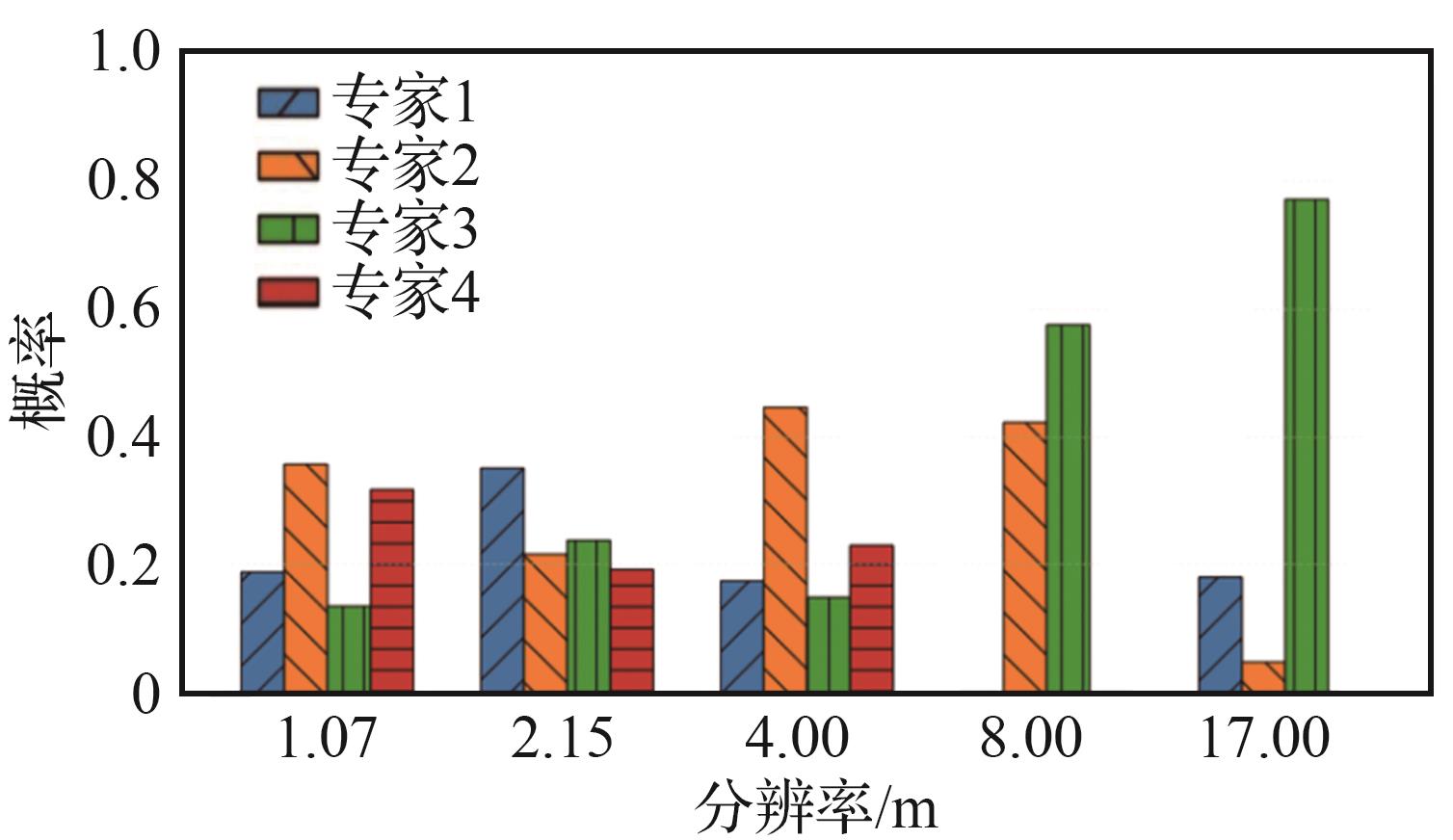

Fig.8
Distribution of experts in longitude-latitude expert group
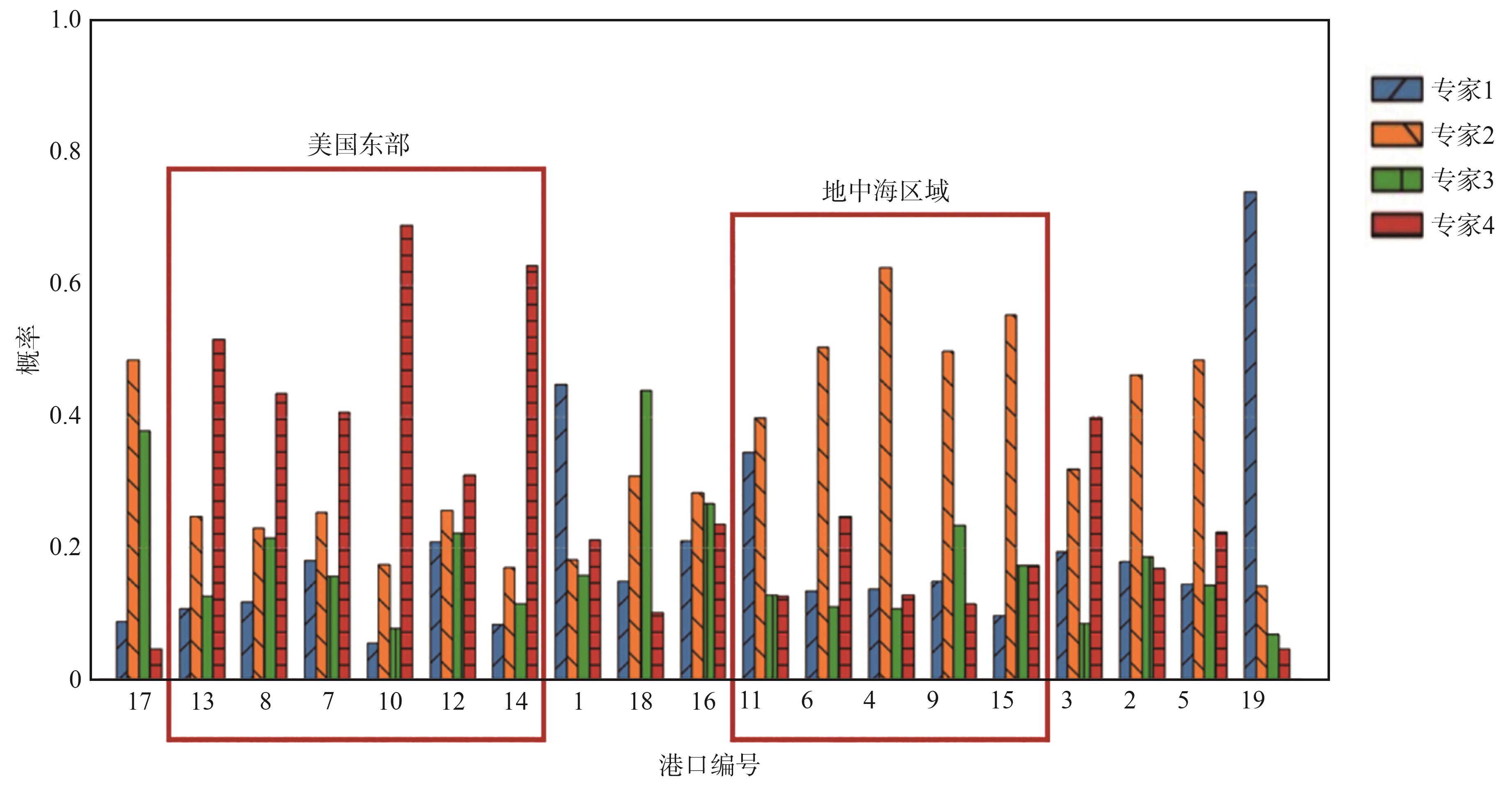
Fig.9
Visualization of detection results of different models on LEVIR-ship dataset
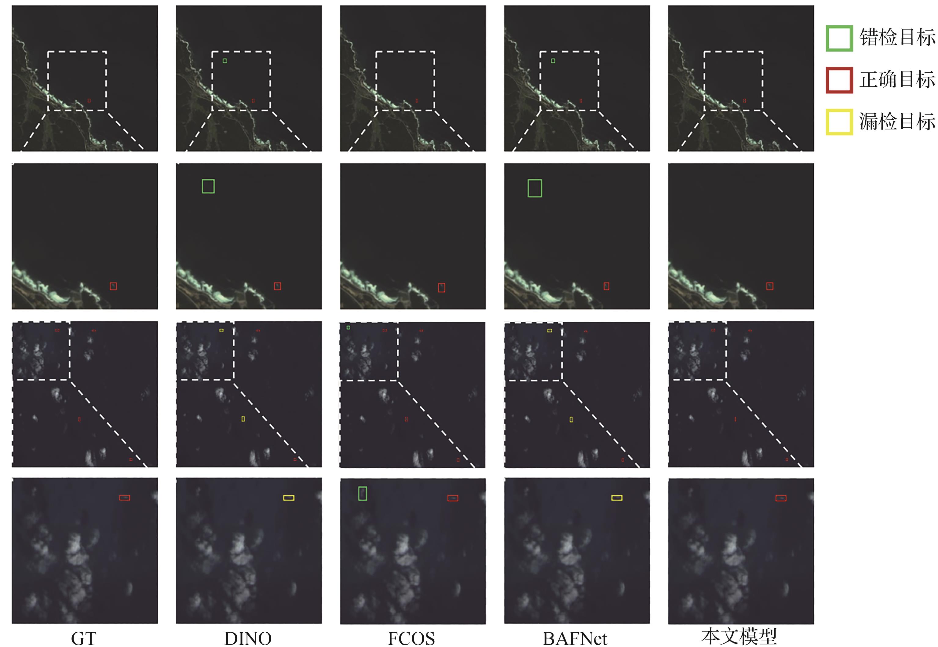
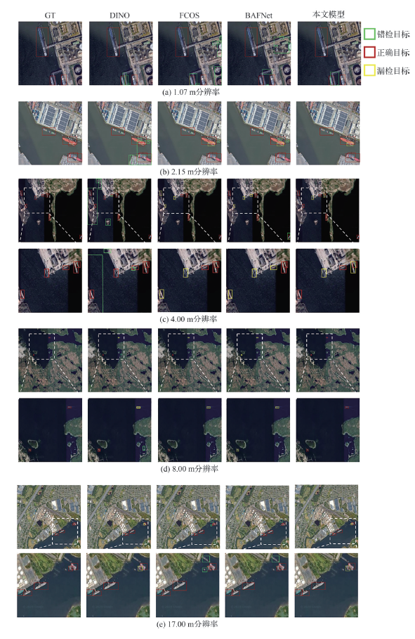
Fig.10
Visualization of detection results of different models on GISD dataset
| [1] | LIN Y F, LI J X, WEI S Q, et al. OptiShipNet: Efficient ship detection in complex marine environments using optical remote sensing images[J]. Journal of Marine Science and Engineering, 2024, 12(10): 1786. |
| [2] | LIU Z H, ZHANG W J, YU H, et al. Improved YOLOv5s for small ship detection with optical remote sensing images[J]. IEEE Geoscience and Remote Sensing Letters, 2023, 20: 8002205. |
| [3] | 肖欣林, 施伟超, 郑向涛, 等. 基于多模型协同的舰船目标检测[J]. 航空学报, 2024, 45(14): 630241. |
| XIAO X L, SHI W C, ZHENG X T, et al. Multiple models collaboration for ship detection[J]. Acta Aeronautica et Astronautica Sinica, 2024, 45(14): 630241 (in Chinese). | |
| [4] | 赵其昌, 吴一全, 苑玉彬. 光学遥感图像舰船目标检测与识别方法研究进展[J]. 航空学报, 2024, 45(8): 029025. |
| ZHAO Q C, WU Y Q, YUAN Y B. Progress of ship detection and recognition methods in optical remote sensing images[J]. Acta Aeronautica et Astronautica Sinica, 2024, 45(8): 029025 (in Chinese). | |
| [5] | ZOU Z X, CHEN K Y, SHI Z W, et al. Object detection in 20 years: A survey[J]. Proceedings of the IEEE, 2023, 111(3): 257-276. |
| [6] | CHEN B W, LIU L Q, ZOU Z X, et al. Target detection in hyperspectral remote sensing image: Current status and challenges[J]. Remote Sensing, 2023, 15(13): 3223. |
| [7] | SHI Z W, YU X R, JIANG Z G, et al. Ship detection in high-resolution optical imagery based on anomaly detector and local shape feature[J]. IEEE Transactions on Geoscience and Remote Sensing, 2014, 52(8): 4511-4523. |
| [8] | 黎经元, 厉小润, 赵辽英. 基于边缘线分析与聚合通道特征的港口舰船检测[J]. 光学学报, 2019, 39(8): 0815004. |
| LI J Y, LI X R, ZHAO L Y. Docked ship detection based on edge line analysis and aggregation channel features[J]. Acta Optica Sinica, 2019, 39(8): 0815004 (in Chinese). | |
| [9] | WANG H L, ZHU M, LIN C B, et al. Ship detection in optical remote sensing image based on visual saliency and AdaBoost classifier[J]. Optoelectronics Letters, 2017, 13(2): 151-155. |
| [10] | GIRSHICK R, DONAHUE J, DARRELL T, et al. Rich feature hierarchies for accurate object detection and semantic segmentation[C]∥ 2014 IEEE Conference on Computer Vision and Pattern Recognition. Piscataway: IEEE Press, 2014. |
| [11] | REDMON J, DIVVALA S, GIRSHICK R, et al. You only look once: Unified, real-time object detection[C]∥2016 IEEE Conference on Computer Vision and Pattern Recognition. Piscataway: IEEE Press, 2016. |
| [12] | CARION N, MASSA F, SYNNAEVE G, et al. End-to-end object detection with transformers[C]∥ 2020 European Conference on Computer Vision. 2020. |
| [13] | LIN H N, SHI Z W, ZOU Z X. Fully convolutional network with task partitioning for inshore ship detection in optical remote sensing images[J]. IEEE Geoscience and Remote Sensing Letters, 2017, 14(10): 1665-1669. |
| [14] | CHEN J Q, CHEN K Y, CHEN H, et al. A degraded reconstruction enhancement-based method for tiny ship detection in remote sensing images with a new large-scale dataset[J]. IEEE Transactions on Geoscience and Remote Sensing, 2022, 60: 5625014. |
| [15] | 王子玲, 熊振宇, 杨璐铖, 等. AIS和光学遥感图像引导的星载SAR舰船目标识别网络[J]. 航空学报, 2024, 45(2): 328672. |
| WANG Z L, XIONG Z Y, YANG L C, et al. Spaceborne SAR ship target recognition network guided by AIS and optical remote sensing images[J]. Acta Aeronautica et Astronautica Sinica, 2024, 45(2): 328672 (in Chinese). | |
| [16] | XING Z J, REN J, FAN X Z, et al. S-DETR: A transformer model for real-time detection of marine ships[J]. Journal of Marine Science and Engineering, 2023, 11(4): 696. |
| [17] | WANG P L, LIU B X, LI Y, et al. IceRegionShip: Optical remote sensing dataset for ship detection in ice-infested waters[J]. IEEE Journal of Selected Topics in Applied Earth Observations and Remote Sensing, 2024, 17: 1007-1020. |
| [18] | YAN Y M, HE Y M, SU N, et al. PNBT-CR: A cloud removal method for ship detection[J]. IEEE Geoscience and Remote Sensing Letters, 2024, 21: 1501905. |
| [19] | 刘子力, 杨家俊, 王文静, 等. 遥感图像云检测方法综述[J]. 中国空间科学技术, 2023, 43(1): 1-17. |
| LIU Z L, YANG J J, WANG W J, et al. Cloud detection methods for remote sensing images: A survey[J]. Chinese Space Science and Technology, 2023, 43(1): 1-17 (in Chinese). | |
| [20] | LI Y X, HOU Q B, ZHENG Z H, et al. Large selective kernel network for remote sensing object detection[C]∥2023 IEEE/CVF International Conference on Computer Vision. Piscataway: IEEE Press, 2024. |
| [21] | MA D Q, LI S J, DANG B, et al. Fostc3net: A lightweight YOLOv5 based on the network structure optimization[J]. Journal of Physics: Conference Series, 2024, 2824(1): 012004. |
| [22] | QIN C, WANG X Q, LI G, et al. An improved attention-guided network for arbitrary-oriented ship detection in optical remote sensing images[J]. IEEE Geoscience and Remote Sensing Letters, 2022, 19: 6514805. |
| [23] | ZOU Z X, SHI Z W. Ship detection in spaceborne optical image with SVD networks[J]. IEEE Transactions on Geoscience and Remote Sensing, 2016, 54(10): 5832-5845. |
| [24] | BI F K, HOU J Y, CHEN L, et al. Ship detection for optical remote sensing images based on visual attention enhanced network[J]. Sensors, 2019, 19(10): 2271. |
| [25] | JACOBS R A, JORDAN M I, NOWLAN S J, et al. Adaptive mixtures of local experts[J]. Neural Computation, 1991, 3(1): 79-87. |
| [26] | FEDUS W, ZOPH B, SHAZEER N. Switch transformers: Scaling to trillion parameter models with simple and efficient sparsity[J]. Journal of Machine Learning Research, 2022, 23(120): 1-39. |
| [27] | CHEN B W, CHEN K Y, YANG M H, et al. Heterogeneous mixture of experts for remote sensing image super-resolution[J]. IEEE Geoscience and Remote Sensing Letters, 2025, 22: 6006405. |
| [28] | XIA G S, BAI X, DING J, et al. DOTA: A large-scale dataset for object detection in aerial images[C]∥ 2018 IEEE/CVF Conference on Computer Vision and Pattern Recognition. Piscataway: IEEE Press, 2018. |
| [29] | LIU Z, LIN Y T, CAO Y, et al. Swin transformer: Hierarchical vision transformer using shifted windows[C]∥ 2021 IEEE/CVF International Conference on Computer Vision. Piscataway: IEEE Press, 20221. |
| [30] | SONG J N, ZHOU M L, LUO J, et al. Boundary-aware feature fusion with dual-stream attention for remote sensing small object detection[J]. IEEE Transactions on Geoscience and Remote Sensing, 2025, 63: 5600213. |
| [31] | TIAN Z, SHEN C H, CHEN H, et al. FCOS: Fully convolutional one-stage object detection[C]∥ 2019 IEEE/CVF International Conference on Computer Vision. Piscataway: IEEE Press, 2019. |
| [32] | HE K M, GKIOXARI G, DOLLÁR P, et al. Mask R-CNN[C]∥ 2017 IEEE International Conference on Computer Vision. Piscataway: IEEE Press, 2017. |
| [33] | ZHANG H, LI F, LIU S L, et al. DINO: DETR with improved DeNoising anchor boxes for end-to-end object detection[DB/OL]. arXiv preprint: 2203.03605, 2022. |
| [34] | ZONG Z F, SONG G L, LIU Y. DETRs with collaborative hybrid assignments training[C]∥ 2023 IEEE/CVF International Conference on Computer Vision. Piscataway: IEEE Press, 2023. |
| [1] | Qichang ZHAO, Yiquan WU, Yubin YUAN. Progress of ship detection and recognition methods in optical remote sensing images [J]. Acta Aeronautica et Astronautica Sinica, 2024, 45(8): 29025-029025. |
| [2] | Xinlin XIAO, Weichao SHI, Xiangtao ZHENG, Yueming GAO, Xiaoqiang LU. Multiple models collaboration for ship detection [J]. Acta Aeronautica et Astronautica Sinica, 2024, 45(14): 630241-630241. |
| [3] | Liqun CHEN, Xu ZOU, Lei ZHANG, Yingpan ZHU, Gang WANG, Jinyong CHEN. On⁃board intelligent target detection technology based on domestic commercial components [J]. Acta Aeronautica et Astronautica Sinica, 2023, 44(S2): 728860-728860. |
| [4] | SU Hang, XU Congan, YAO Libo, LI Jianwei, LING Qing, GAO Long. A lightweight oriented ship detection method in SAR images [J]. ACTA AERONAUTICAET ASTRONAUTICA SINICA, 2022, 43(S1): 726922-726922. |
| Viewed | ||||||
|
Full text |
|
|||||
|
Abstract |
|
|||||
Address: No.238, Baiyan Buiding, Beisihuan Zhonglu Road, Haidian District, Beijing, China
Postal code : 100083
E-mail:hkxb@buaa.edu.cn
Total visits: 6658907 Today visits: 1341All copyright © editorial office of Chinese Journal of Aeronautics
All copyright © editorial office of Chinese Journal of Aeronautics
Total visits: 6658907 Today visits: 1341