| 1 |
AGGARWAL S, KUMAR N. Path planning techniques for unmanned aerial vehicles: A review, solutions, and challenges[J]. Computer Communications, 2020, 149: 270-299.
|
| 2 |
路晶, 史宇, 张书畅, 等. 无人机航迹规划算法综述[J]. 航空计算技术, 2022, 52(4): 131-134.
|
|
LU J, SHI Y, ZHANG S C, et al. A review of UAV trajectory planning algorithms[J]. Aeronautical Computing Technique, 2022, 52(4): 131-134 (in Chinese).
|
| 3 |
刘好. 复杂环境下四旋翼无人机航迹规划算法研究[D]. 长沙: 中南大学, 2023:4-8.
|
|
LIU H. Research on path planning algorithm of quadrotor UAV in complex environment[D]. Changsha: Central South University, 2023: 4-8 (in Chinese).
|
| 4 |
YU Z, SUN F C, LU X, et al. Overview of research on 3D path planning methods for rotor UAV[C]∥2021 International Conference on Electronics, Circuits and Information Engineering (ECIE). Piscataway: IEEE Press, 2021: 368-371.
|
| 5 |
刘玄冰, 周绍磊, 肖支才, 等. 无人机避障方法研究综述[J]. 兵器装备工程学报, 2022, 43(5): 40-47.
|
|
LIU X B, ZHOU S L, XIAO Z C, et al. Review on UAV obstacle avoidance methods[J]. Journal of Ordnance Equipment Engineering, 2022, 43(5): 40-47 (in Chinese).
|
| 6 |
GOLL S A, LUKSHA S S, LEUSHKIN V S, et al. Unmanned ground vehicle local trajectory planning algorithm[C]∥2016 5th Mediterranean Conference on Embedded Computing (MECO). Piscataway: IEEE Press, 2016: 317-321.
|
| 7 |
贾高伟, 王建峰. 无人机集群任务规划方法研究综述[J]. 系统工程与电子技术, 2021, 43(1): 99-111.
|
|
JIA G W, WANG J F. Research review of UAV swarm mission planning method[J]. Systems Engineering and Electronics, 2021, 43(1): 99-111 (in Chinese).
|
| 8 |
SAADI A AIT, SOUKANE A, MERAIHI Y, et al. UAV path planning using optimization approaches: A survey[J]. Archives of Computational Methods in Engineering, 2022, 29(6): 4233-4284.
|
| 9 |
ECONOMOU J T, KLADIS G, TSOURDOS A, et al. UAV optimum energy assignment using Dijkstra’s algorithm[C]∥2007 European Control Conference (ECC). Piscataway: IEEE Press, 2007: 287-292.
|
| 10 |
TANG B, HIROTA K, WU X, et al. Path planning based on improved hybrid A* algorithm[J]. Journal of Advanced Computational Intelligence and Intelligent Informatics, 2021, 25(1): 6472.
|
| 11 |
TOIBERO J M, ROBERTI F, CARELLI R, et al. Switching control approach for stable navigation of mobile robots in unknown environments[J]. Robotics and Computer-Integrated Manufacturing, 2011, 27(3): 558-568.
|
| 12 |
WEBB D J, VAN DEN BERG J. Kinodynamic RRT*: Optimal motion planning for systems with linear differential constraints[DB/OL].arXiv preprint: 1205.5088;2012.
|
| 13 |
许万, 杨晔, 余磊涛, 等. 一种基于改进RRT*的全局路径规划算法[J]. 控制与决策, 2022, 37(4): 829-838.
|
|
XU W, YANG Y, YU L T, et al. A global path planning algorithm based on improved RRT* [J]. Control and Decision, 2022, 37(4): 829-838 (in Chinese).
|
| 14 |
张伟民, 付仕雄. 基于改进RRT*算法的移动机器人路径规划[J]. 华中科技大学学报(自然科学版), 2021, 49(1): 31-36.
|
|
ZHANG W M, FU S X. Mobile robot path planning based on improved RRT* algorithm[J]. Journal of Huazhong University of Science and Technology (Natural Science Edition), 2021, 49(1): 31-36 (in Chinese).
|
| 15 |
ZHANG C, HU C X, FENG J R, et al. A self-heuristic ant-based method for path planning of unmanned aerial vehicle in complex 3-D space with dense U-type obstacles[J]. IEEE Access, 2019, 7: 150775-150791.
|
| 16 |
LEE K, CHOI D, KIM D. Incorporation of potential fields and motion primitives for the collision avoidance of unmanned aircraft[J]. Applied Sciences, 2021, 11(7): 3103.
|
| 17 |
CHEN X, ZHANG J. The three-dimension path planning of UAV based on improved artificial potential field in dynamic environment[C]∥2013 5th International Conference on Intelligent Human-Machine Systems and Cybernetics. Piscataway: IEEE Press, 2013: 144-147.
|
| 18 |
MELLINGER D, KUMAR V. Minimum snap trajectory generation and control for quadrotors[C]∥2011 IEEE International Conference on Robotics and Automation. Piscataway: IEEE Press, 2011: 2520-2525.
|
| 19 |
GAO F, WANG L Q, ZHOU B Y, et al. Teach-repeat-replan: A complete and robust system for aggressive flight in complex environments[J]. IEEE Transactions on Robotics, 2020, 36(5): 1526-1545.
|
| 20 |
汪哲培. 多旋翼无人机运动规划的几何方法[D]. 杭州: 浙江大学, 2022:33-56.
|
|
WANG Z P. Geometric method for motion planning of multi-rotor UAV[D]. Hangzhou: Zhejiang University, 2022: 33-56 (in Chinese).
|
| 21 |
HORN R A, JOHNSON C R. Matrix analysis[M]. 2nd ed. Cambridge: Cambridge University Press, 2012: 163-224.
|
| 22 |
LIU D C, NOCEDAL J. On the limited memory BFGS method for large scale optimization[J]. Mathematical Programming, 1989, 45(1): 503-528.
|
| 23 |
XU W, CAI Y X, HE D J, et al. FAST-LIO2: Fast direct LiDAR-inertial odometry[J]. IEEE Transactions on Robotics, 2022, 38(4): 2053-2073.
|
| 24 |
ZHANG H X, TAO Y D, ZHU W L. Global path planning of unmanned surface vehicle based on improved A-star algorithm[J]. Sensors, 2023, 23(14): 6647.
|
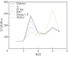
 ), 陈欣1, 魏鹏轩1, 李嘉诚2, 陈芊1