Acta Aeronautica et Astronautica Sinica ›› 2026, Vol. 47 ›› Issue (14): 333591.doi: 10.7527/S1000-6893.2026.33591
• Electronics and Electrical Engineering and Control • Previous Articles
Chuang SHI1,2,3,4, Kunlei LI2,3, Jiale WANG1,3,4,5( ), Ming XIA1,3,4, Shijun CHEN3,6, Xin JIANG3,7, Xiayu LI3,8, Yi WAN3,8, He ZHANG3,9, Yao JIN3,9
Received:2026-03-19
Revised:2026-04-13
Accepted:2026-05-29
Online:2026-06-24
Published:2026-06-23
Contact:
Jiale WANG
E-mail:wang_jiale@buaa.edu.cn
Supported by:CLC Number:
Chuang SHI, Kunlei LI, Jiale WANG, Ming XIA, Shijun CHEN, Xin JIANG, Xiayu LI, Yi WAN, He ZHANG, Yao JIN. Empowering low-altitude economy with BDS/5G integrated spatiotemporal network: Technical architecture, application practice and future prospect[J]. Acta Aeronautica et Astronautica Sinica, 2026, 47(14): 333591.
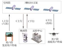
Fig.1
Principle of regional short message implementation
Table 1
Performance summary of BDS positioning methods
| 定位方法 | 水平RMS/m | 垂直RMS/m |
|---|---|---|
| SPP[ | 5.0 | 10.0 |
| PPP[ | 0.3 | 0.5 |
| PPP-RTK[ | 0.025 | 0.05 |
| RTK/NRTK[ | 0.01 | 0.02 |
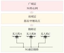
Fig.2
Hierarchical data transmission architecture for UAVs based on 5G communication[18]
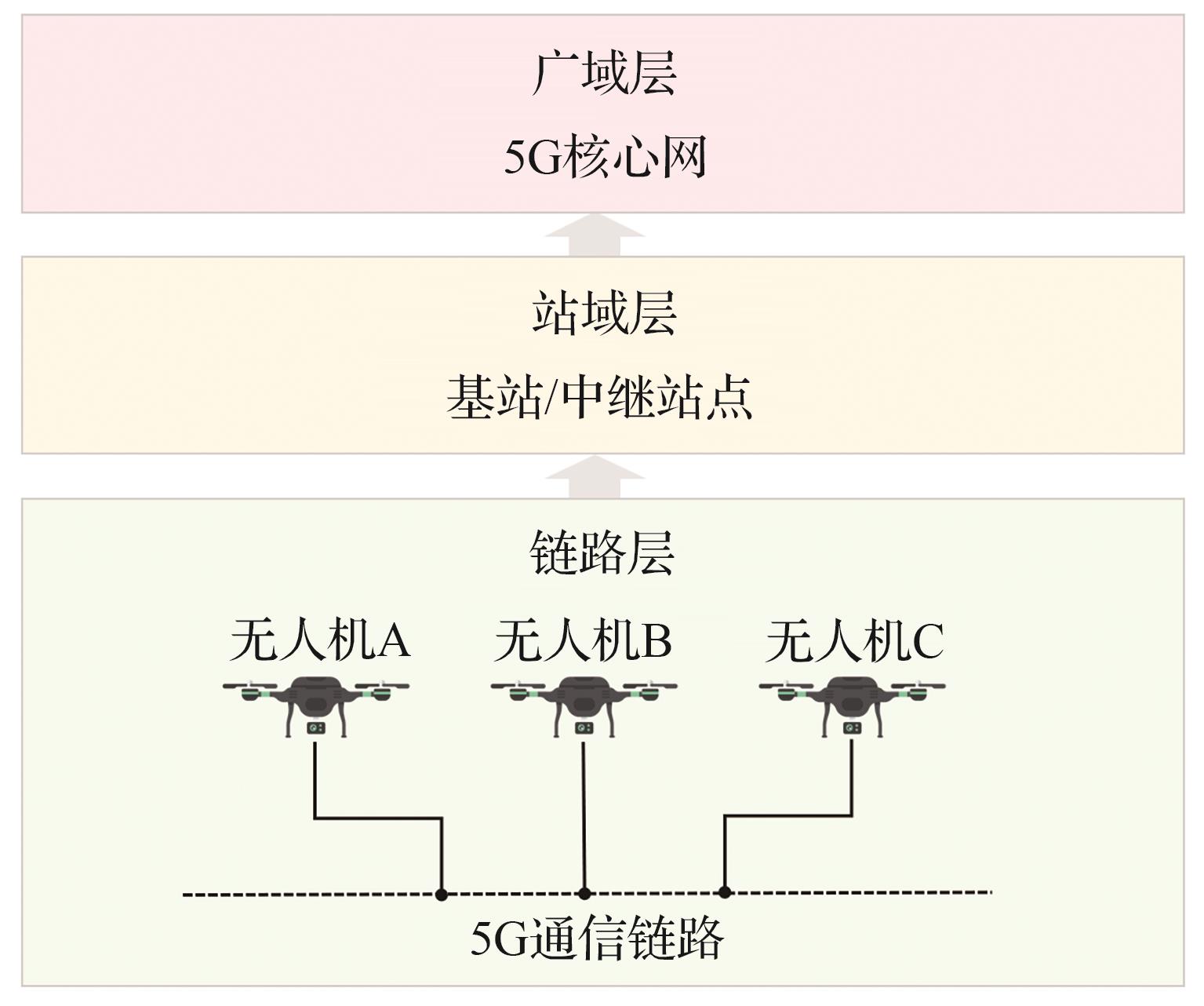
Fig.3
Three schematics of 5G positioning methods
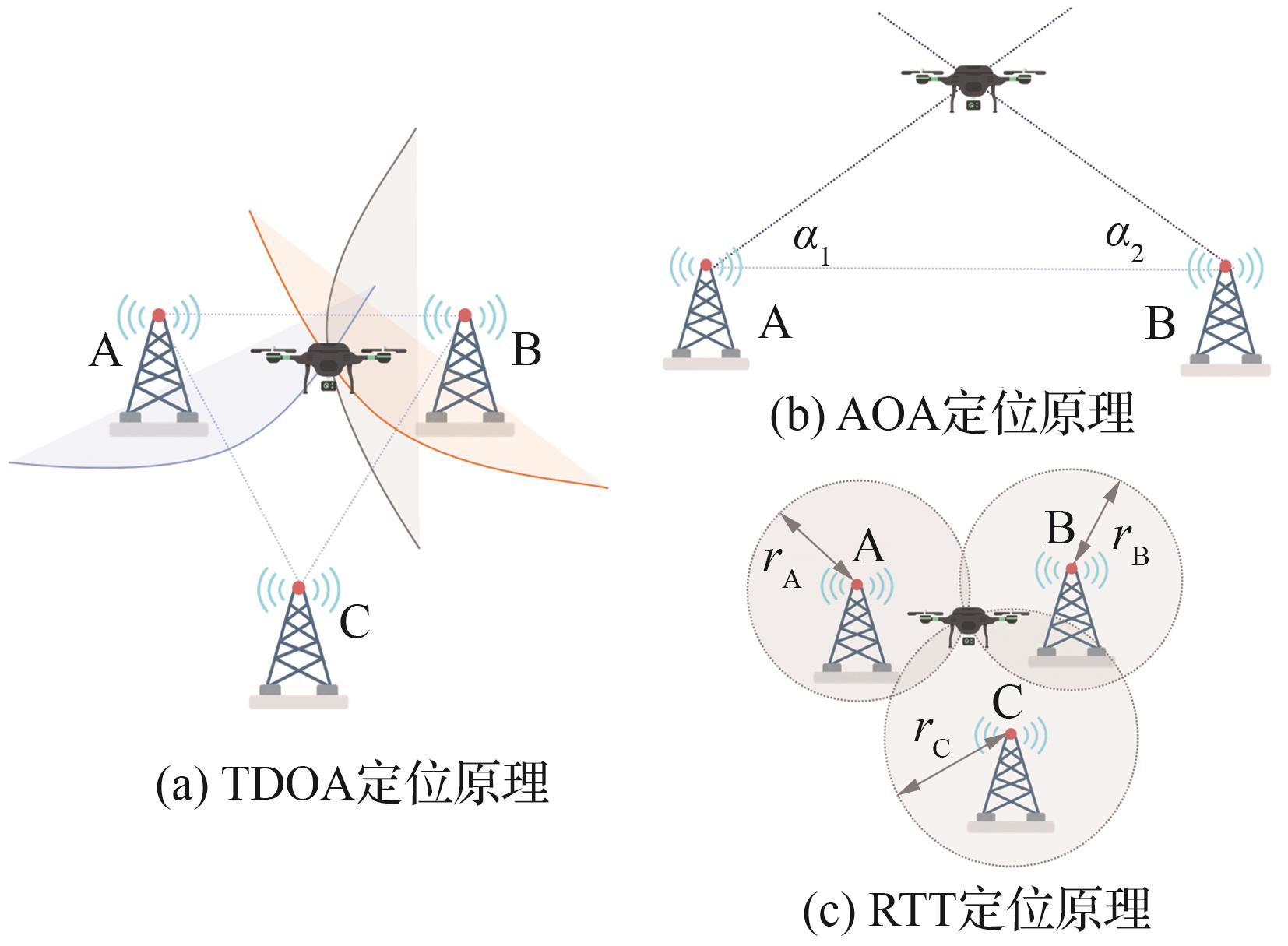
Table 2
Comparison of BDS+5G integrated base stations
| 方案 | 北斗模块组成 | 5G模块复用 | 信号流向 |
|---|---|---|---|
| 5G+伪卫星一体化基站[ | 多通道伪卫星发射主机、多频收发天线、射频线缆 | 复用5G射频链路、天线与传输资源,共址发射5G信号与北斗等伪卫星信号 | 基站主动发射北斗/GPS L波段信号+5G通信信号 |
| 5G+北斗基准站一体化基站[ | 北斗3D扼流圈接收天线、北斗信号接收板卡、数据中心/播发控制模块 | 复用5G AAU/BBU、供电单元与回传链路,由5G射频单元播发北斗增强数据 | 基站被动接收北斗卫星信号→生成差分数据→5G链路广播给用户 |
| 5G-A+北斗通感导一体化基站[ | 改造后的北斗授时模块 (可输出卫星测量信息) | 复用5G-A通感一体AAU/BBU、授时模块与感知链路,实现通感导协同 | 基站接收北斗信号→生成RTK改正数→修正感知参数并提供定位服务 |
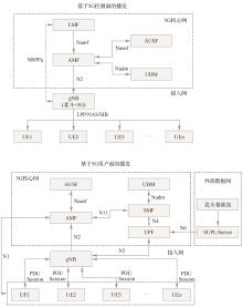
Fig.4
Architecture comparison between 5G user plane broadcast and control plane broadcast
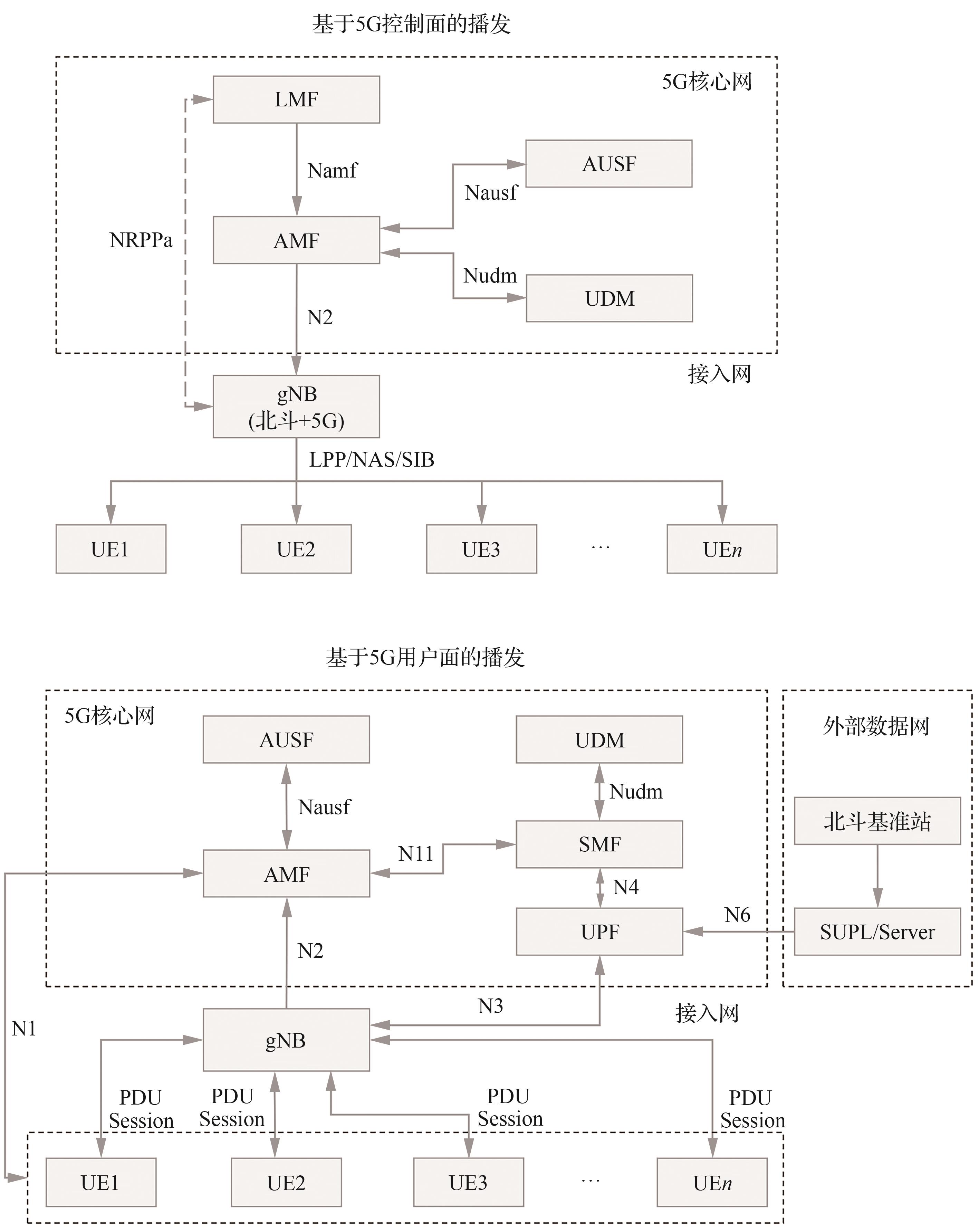
Fig.5
Mode comparison between user plane broadcast in 5G base stations and control plane broadcast in BDS/5G integrated base stations[42]
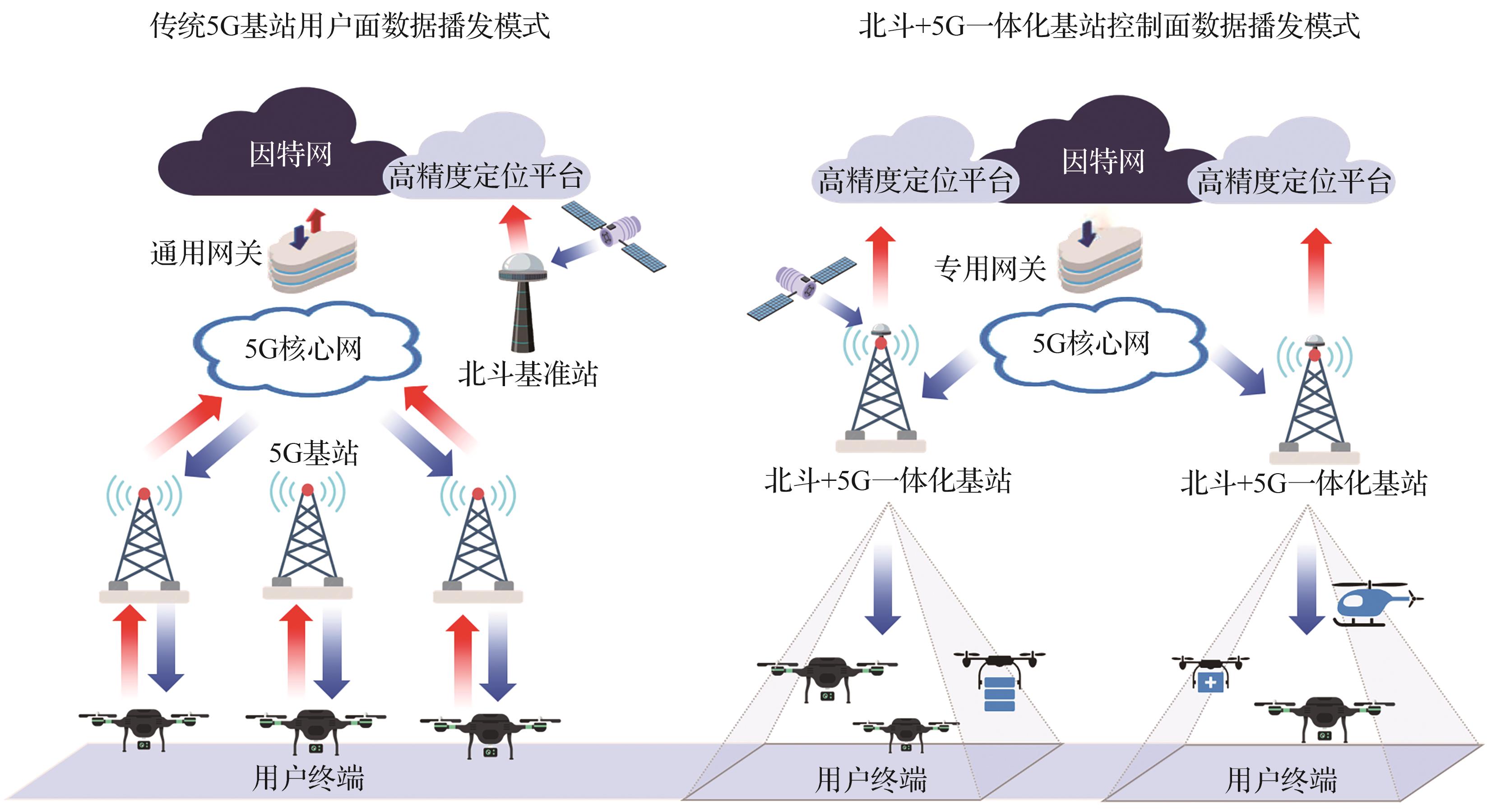
Table 3
Technical comparison between user plane broadcast in 5G base stations and control plane broadcast in BDS/5G integrated base stations
| 对比维度 | 用户面播发 | 控制面播发 |
|---|---|---|
| 传输模式 | 点对点单播信道,数据经PDU会话逐一传输至目标终端,资源消耗容量和终端数量的关系为 | 广播信道,数据经一条公共信道同时传输给区域所有终端,资源消耗容量与终端数量无关,主要受广播带宽和覆盖区最弱接收条件约束 |
| 资源调度机制 | 动态资源调度机制,符合M/M/1排队模型,终端的请求随机到达基站,单个请求的平均等待时延为 | 静态资源预留机制,可为数据预留固定的控制面时隙和频域资源,并优先调度,避开排队过程,端到端的时延仅有信号传播时延和协议处理时延组成,整体可控制在1~10 ms,与终端和网络负载无关 |
| 协议栈路径 | 数据平面完整栈,路径为应用层→传输层→IP层→用户面协议栈,其中传输层的3次握手、重传机制与IP层的路由寻址,会引入至少3层协议开销,协议栈主要包括TCP/UDP、IP、SDAP、PDCP、RLC、MAC、PHY | 控制平面轻量级栈,路径为定位信令→NAS层→控制面协议栈,数据嵌入定位信令或者控制面广播流程,协议栈主要包括LPP/NAS/RRC、PDCP、RLC、MAC、PHY |
| 移动性管理方式 | PDU会话承载与基站局部资源强绑定,终端跨基站切换时,必须释放原有资源,引入100~500 ms的数据中断 | 广播承载与核心网全局资源绑定,终端跨基站切换时,无需重建任何承载,数据由核心网AFM统一调度 |
| 安全机制 | 应用层附加安全,加密与鉴权由外部SUPL服务器实现,密钥在终端与服务器之间协商生成,安全等级完全依赖应用层的实现,无法复用5G网络原生安全能力 | 网络层原生安全,加密与鉴权由5G核心网AMF与AUSF原生实现,密钥与终端的SIM卡身份绑定,由核心网统一生成与分发,安全等级与5G核心网完全一致 |
Fig.6
Core technical architecture of BDS/5G integrated spatiotemporal network
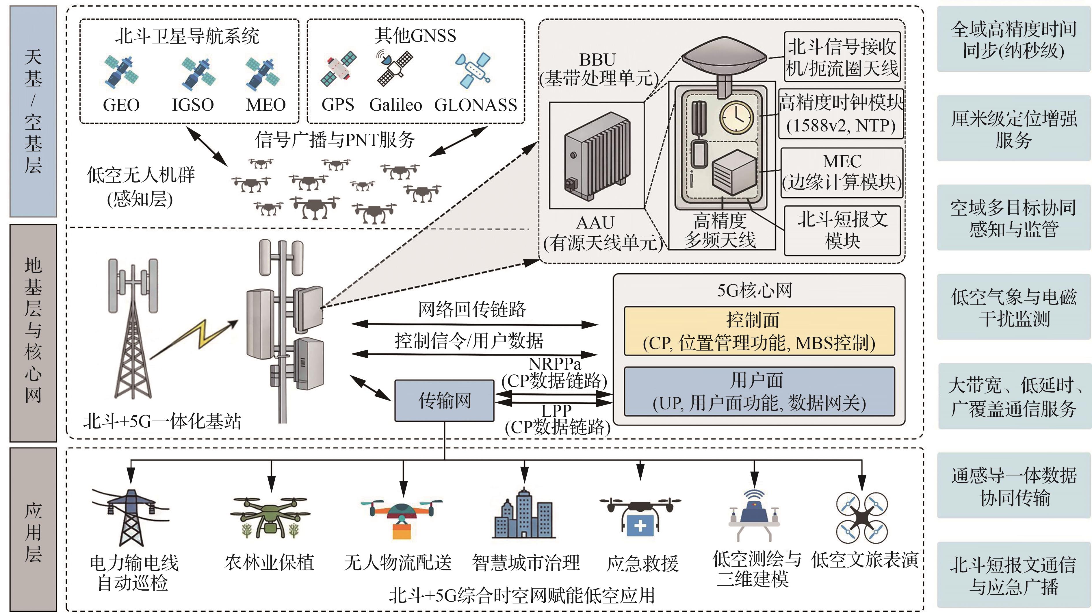
Fig.7
Time synchronization schematic for BDS/5G integrated base stations and UAV swarm
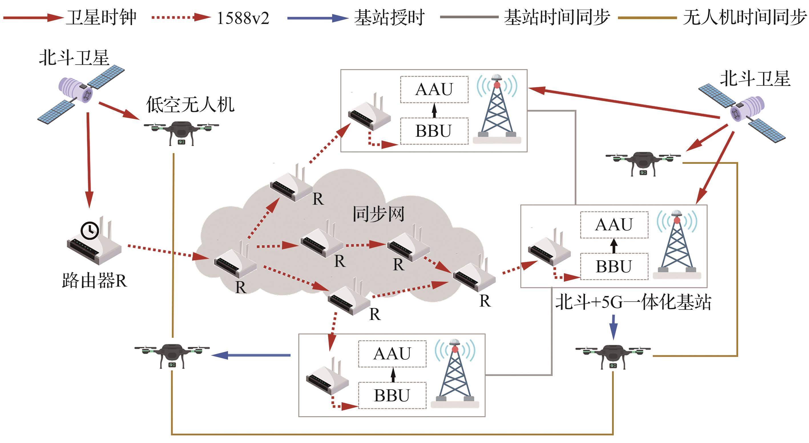
Table 4
Application scenarios of BDS/5G integrated base stations in low-altitude economy
| 应用场景 | 核心需求 | 文献 |
|---|---|---|
| 电力输电线自动巡线 | 北斗RTK厘米级定位;巡检图像实时回传 | [ |
| 农林业植保 | 回传位置和飞行轨迹;多模态数据采集;病虫害监测;精准喷施 | [ |
| 物流配送 | 高精度定位;路径规划 | [ |
| 智慧城市治理 | 图像采集;建筑巡检;交通管制 | [ |
| 应急救援 | 灾害区域精准定位与连续导航 | [ |
| 低空测绘与三维建模 | 厘米级/分米级高精度定位;点云数据高速回传;多机协同航测 | [ |
| 低空文旅表演 | 厘米级编队定位与同步控制;指令接受与下发 | [ |
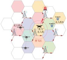
Fig.8
Low-altitude perception intelligent network networking and operation mode
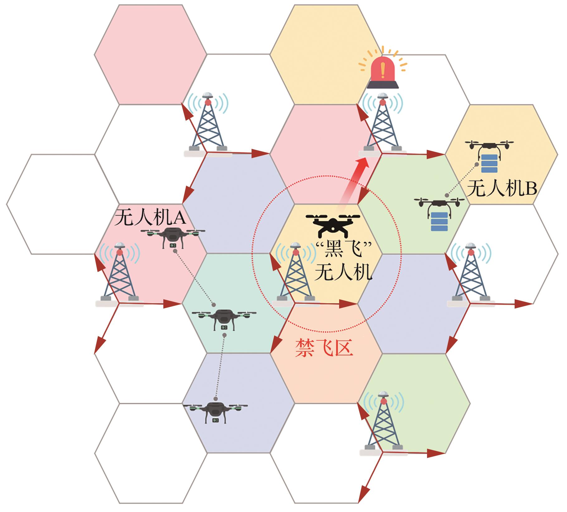
Fig.9
Empowering multi-domain applications of low-altitude economy via BDS/5G integrated spatiotemporal network
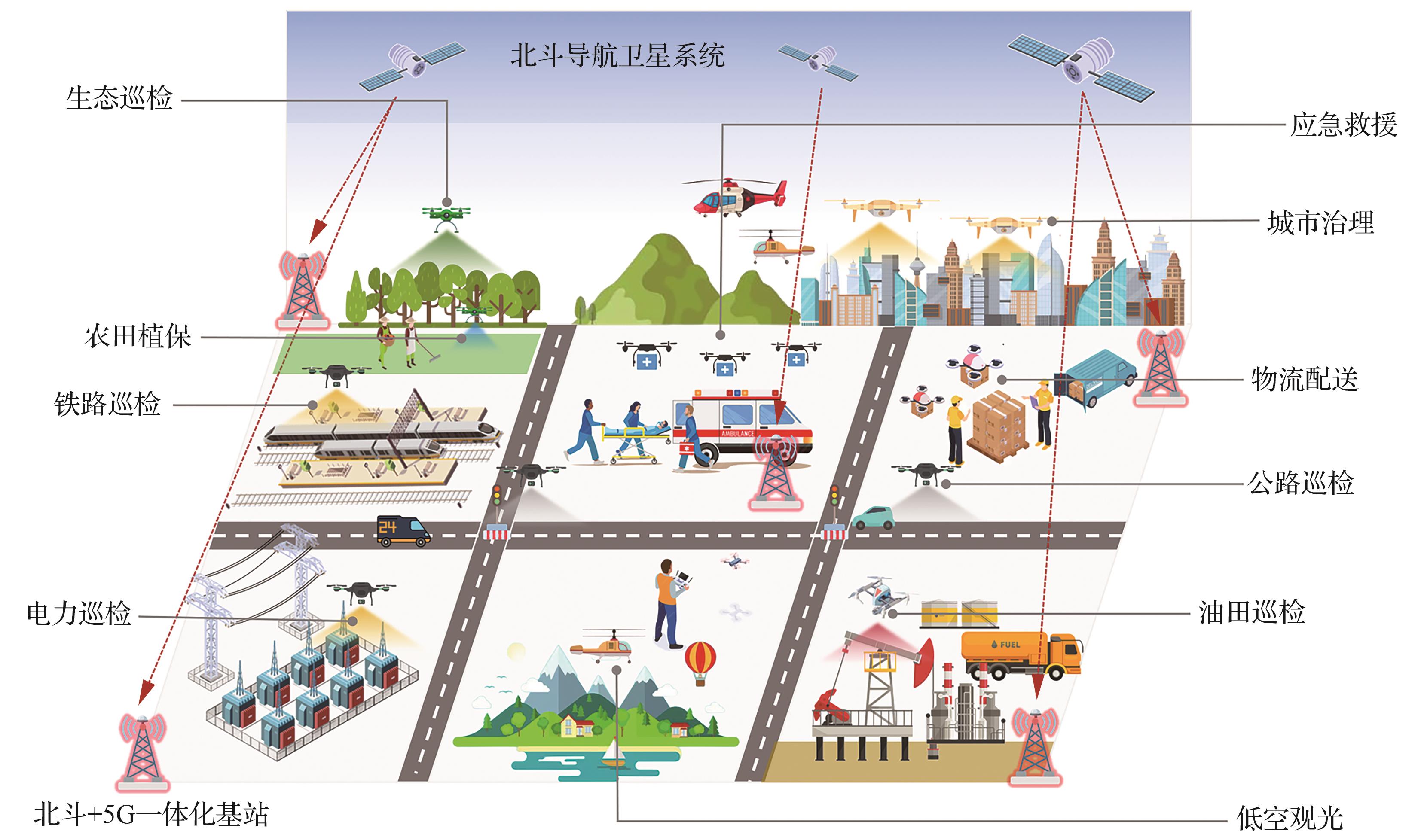
Table 5
5G communication-navigation integration and BDS spatiotemporal service standard system
| 标准体系归属 | 标准层级 | 标准编号 | 标准名称 |
|---|---|---|---|
| 5G通导融合技术标准体系 | 行业标准 | YD/T 3628-2019 | 5G移动通信网安全技术要求 |
| 行业标准 | YD/T 3936-2021 | 基于移动通信网的高精度定位总体技术要求 | |
| 行业标准 | YD/T 4745-2024 | 基于服务化架构的5G核心网增强位置业务总体技术要求 | |
| 国际标准 | 3GPP TS 23.273 V16.0.0 | 5G系统位置服务第2阶段(5G System (5GS) location services Stage 2) | |
| 国际标准 | 3GPP TS 23.502 V16.0.0 | 5G系统流程(Procedures for 5G System (5GS)) | |
| 国际标准 | 3GPP TS 29.500 V16.0.0 | 基于服务化架构的5G系统技术实现 (5G system technical realization of service based architecture) | |
| 国际标准 | 3GPP TS 29.518 V16.0.0 | 5G系统接入和移动管理服务第3阶段 (5G System; Access and mobility management services; Stage 3) | |
| 国际标准 | 3GPP TS 37.355 V16.0.0 | NR定位协议 (NR positioning protocol) | |
| 国际标准 | 3GPP TS 38.305 V16.0.0 | NG-RAN用户设备定位 (User Equipment positioning in NG-RAN) | |
| 国际标准 | 3GPP TS 38.413 V16.0.0 | NG-RAN应用协议 (NG-RAN; NG Application Protocol (NGAP)) | |
| 国际标准 | 3GPP TS 38.455 V16.0.0 | NR定位附加协议 (NR positioning protocol A) | |
| 国际标准 | OMA-AD-SUPL V2.0 | 安全用户面定位架构协议 (Secure user plane location architecture) | |
| 北斗时空服务标准体系 | 国际标准 | RTCM10403.3 | 差分数据GNSS服务标准(第3版) (Differential GNSS services Version 3) |
| 国家标准 | GB/T 37019.1-2018 | 卫星导航地基增强系统播发接口规范第1部分:移动通信网 | |
| 国家标准 | GB/T 35767—2017 | 卫星导航定位基准站网基本产品规范 | |
| 国家标准 | GB/T 39721-2021 | 北斗地基增强系统基准站入网技术要求 | |
| 国家标准 | GB/T 39723-2020 | 北斗地基增强系统通信网络系统技术规范 | |
| 国家标准 | GB/T 39772.1-2021 | 北斗地基增强系统基准站建设和验收技术规范 第1部分:建设规范 | |
| 国家标准 | GB/T 44088-2024 | 北斗卫星导航系统测量型模块技术要求及测试方法 | |
| 国家标准 | GB/T 44485-2024 | 北斗地基增强系统实时定位分级服务内容及数据格式 | |
| 国家标准 | GB/T 44068-2024 | LTE移动通信终端支持北斗定位的技术要求 | |
| 地方标准 | DB13/T 6036-2024 | 北斗+5G一体化融合位置服务通用规范 |
| [1] | 孙文浩, 张杰. 低空经济赋能城市高质量发展的成效与路径研究[J]. 商业经济与管理, 2026(2): 62-76. |
| SUN W H, ZHANG J. Empowering high-quality urban development through the low-altitude economy: Effects and pathways[J]. Journal of Business Economics, 2026(2): 62-76 (in Chinese). | |
| [2] | 张海君, 夏清悦, 马旭, 等. 6G低空通信场景下无人机部署优化综述[J]. 航空学报, 2025, 46(11): 531296. |
| ZHANG H J, XIA Q Y, MA X, et al. A review of unmanned aerial vehicles deployment optimization in 6G low-altitude communication scenarios[J]. Acta Aeronautica et Astronautica Sinica, 2025, 46(11): 531296 (in Chinese). | |
| [3] | 胡文晓, 牟迪, 李智, 等. 低空经济发展的关键技术问题与创新策略[J]. 航空学报, 2025, 46(11): 531539. |
| HU W X, MU D, LI Z, et al. Key technical issues and innovation strategies for development of low-altitude economy[J]. Acta Aeronautica et Astronautica Sinica, 2025, 46(11): 531539 (in Chinese). | |
| [4] | LI B, FEI Z S, ZHANG Y, et al. Secure UAV communication networks over 5G[J]. IEEE Wireless Communications, 2019, 26(5): 114-120. |
| [5] | JIANG C P, ZHOU X Y, CHEN H, et al. UAV positioning using GNSS: A review of the current status[J]. Drones, 2026, 10(2): 91. |
| [6] | 金耀, 张贺, 邓中亮, 等. 5G-A/6G+北斗通感导技术在低空经济中的应用与展望[J]. 电信科学, 2025, 41(3): 1-16. |
| JIN Y, ZHANG H, DENG Z L, et al. Application and prospect of 5G-A/6G+Beidou communication, sensing and navigation technology in low-altitude economy[J]. Telecommunications Science, 2025, 41(3): 1-16 (in Chinese). | |
| [7] | 王瑛, 边朗, 杨涛, 等. 卫星导航技术发展综述[J]. 空间电子技术, 2025, 22(S1): 20-34. |
| WANG Y, BIAN L, YANG T, et al. A review of the development of satellite navigation technology[J]. Space Electronic Technology, 2025, 22(S1): 20-34 (in Chinese). | |
| [8] | 朱小韦, 袁占良, 杨耀环. 北斗三号卫星导航系统精密单点定位的性能分析[J]. 测绘通报, 2023(9): 6-11, 58. |
| ZHU X W, YUAN Z L, YANG Y H. Performance analysis of precise point positioning of BeiDou-3 navigation satellite system[J]. Bulletin of Surveying and Mapping, 2023(9): 6-11, 58 (in Chinese). | |
| [9] | 李平, 王璐, 聂欣, 等. “北斗”短报文通信现状与发展[J]. 中国航天, 2024(5): 44-49. |
| LI P, WANG L, NIE X, et al. The current situation and development of “BeiDou” short message communications[J]. Aerospace China, 2024(5): 44-49 (in Chinese). | |
| [10] | 田露, 李骏平, 刘蕾. 基于星间链路的全球短报文服务可用性分析[J]. 中国空间科学技术(中英文), 2024, 44(5): 166-174. |
| TIAN L, LI J P, LIU L. Analysis of global short message service availability based on inter-satellite link[J]. Chinese Space Science and Technology, 2024, 44(5): 166-174 (in Chinese). | |
| [11] | HU J H, LI P, ZHANG X H, et al. Precise point positioning with BDS-2 and BDS-3 constellations: Ambiguity resolution and positioning comparison[J]. Advances in Space Research, 2022, 70(7): 1830-1846. |
| [12] | EKASO D, NEX F, KERLE N. Accuracy assessment of real-time kinematics (RTK) measurements on unmanned aerial vehicles (UAV) for direct geo-referencing[J]. Geo-spatial Information Science, 2020, 23(2): 165-181. |
| [13] | 于素君, 易昌华, 李春芬, 等. 北斗卫星导航系统定位原理及其应用综述[J]. 物探装备, 2020, 30(1): 59-63. |
| YU S J, YI C H, LI C F, et al. The positioning principle and application of Beidou satellite navigation system[J]. Equipment for Geophysical Prospecting, 2020, 30(1): 59-63 (in Chinese). | |
| [14] | 莫武, 余学祥. 基于RTK技术的无人机实时动态定位算法优化[J]. 现代信息科技, 2026, 10(4): 8-12. |
| MO W, YU X X. Optimization of real-time dynamic positioning algorithm for UAVs based on RTK technology[J]. Modern Information Technology, 2026, 10(4): 8-12 (in Chinese). | |
| [15] | SUFYAN A, KHAN K B, KHASHAN O A, et al. From 5G to beyond 5G: A comprehensive survey of wireless network evolution, challenges, and promising technologies[J]. Electronics, 2023, 12(10): 2200. |
| [16] | ATALAY T O, STOJADINOVIC D, FAMILI A, et al. A first look at 5G core deployments on public cloud: Performance evaluation of control and user planes[DB/OL]. arXiv preprint: 2312.04833; 2023. |
| [17] | 王书亚, 王振, 季璐. 面向5G网络的无人机通信关键技术研究[J]. 软件, 2025, 46(8): 146-148. |
| WANG S Y, WANG Z, JI L. Research on key technologies of UAV communication for 5G network[J]. Software, 2025, 46(8): 146-148 (in Chinese). | |
| [18] | 潘林杰. 低空无人机群5G实时数传机制研究[J]. 电信快报, 2026(1): 36-38, 44. |
| PAN L J. Research on real-time data transmission mechanism based on 5G communication in low-altitude UAV swarms[J]. Telecommunications Information, 2026(1): 36-38, 44 (in Chinese). | |
| [19] | BRAMBILLA M, ALGHISI M, CAMAJORI TEDESCHINI B, et al. Integration of 5G and GNSS technologies for enhanced positioning: An experimental study[J]. IEEE Open Journal of the Communications Society, 2024, 5: 7197-7215. |
| [20] | WANG Y, HUANG S, YU Y J, et al. Recent progress on 3GPP 5G positioning[C]∥2023 IEEE 97th Vehicular Technology Conference (VTC2023-Spring). Piscataway: IEEE Press, 2023: 1-6. |
| [21] | BAI L, SUN C, ZHAO H B, et al. A TOA-AOA hybrid localization method in 5G network with MIMO antennas[C]∥China Satellite Navigation Conference (CSNC 2021) Proceedings. Singapore: Springer, 2021: 285-295. |
| [22] | DEL PERAL-ROSADO J A, GUNNARSSON F, DWIVEDI S, et al. Exploitation of 3D city maps for hybrid 5G RTT and GNSS positioning simulations[C]∥ICASSP 2020-2020 IEEE International Conference on Acoustics, Speech and Signal Processing (ICASSP). Piscataway: IEEE Press, 2020: 9205-9209. |
| [23] | 蔡子华, 吴浩, 刘子建, 等. 基于5G核心网开放架构的工业园区高精度定位系统设计与实现[J]. 数据通信, 2025(6): 1-4, 14. |
| CAI Z H, WU H, LIU Z J, et al. Design and implementation of HighPrecision positioning system for industrial parks based on open 5G core network architecture[J]. Data Communications, 2025(6): 1-4, 14 (in Chinese). | |
| [24] | CHEN W X, WANG T F, YAO Z, et al. Analysis of the gain factors of 5G-assisted BDS RTK positioning in urban environments[J]. Satellite Navigation, 2024, 5(1): 28. |
| [25] | LI F X, TU R, HONG J, et al. Combined positioning algorithm based on BeiDou navigation satellite system and raw 5G observations[J]. Measurement, 2022, 190: 110763. |
| [26] | HUANG C, MOLISCH A F, HE R S, et al. Machine learning-enabled LOS/NLOS identification for MIMO systems in dynamic environments[J]. IEEE Transactions on Wireless Communications, 2020, 19(6): 3643-3657. |
| [27] | 李志强. “北斗+广播”高精定位新模式探讨[J]. 广播电视网络, 2021, 28(8): 72-73, 75. |
| LI Z Q. Discussion on the new mode of “Beidou+Broadcasting” high-precision positioning[J]. Radio & Television Network, 2021, 28(8): 72-73, 75 (in Chinese). | |
| [28] | 金耀, 张贺, 王泽林, 等. 北斗短报文发展与应用[J]. 邮电设计技术, 2024(3): 53-57. |
| JIN Y, ZHANG H, WANG Z L, et al. Development and application of Beidou short message[J]. Designing Techniques of Posts and Telecommunications, 2024(3): 53-57 (in Chinese). | |
| [29] | 赵智慧. 北斗用于5G基站高精度授时的应用探讨[J]. 长江信息通信, 2023, 36(3): 189-192. |
| ZHAO Z H. Discussion on the application of Beidou in high-precision time service of 5G base station[J]. Changjiang Information & Communications, 2023, 36(3): 189-192 (in Chinese). | |
| [30] | 朵灏, 王文跃, 蒋鑫. 深入推进5G网络建设面临问题的研究[J]. 通信世界, 2024(19): 14-15. |
| DUO H, WANG W Y, JIANG X. Research on problems in further promoting the construction of 5G network[J]. Communications World, 2024(19): 14-15 (in Chinese). | |
| [31] | 曹亘, 吕婷, 张涛, 等. 中国联通5G基站设备架构及演进要求[J]. 邮电设计技术, 2019(8): 12-15. |
| CAO G, LÜ T, ZHANG T, et al. 5G base station architecture and evolution requirements of China unicom[J]. Designing Techniques of Posts and Telecommunications, 2019(8): 12-15 (in Chinese). | |
| [32] | CAI B W, ZHANG H, GUO H, et al. 5G network evolution and dual-mode 5G base station[C]∥2020 IEEE 6th International Conference on Computer and Communications (ICCC). Piscataway: IEEE Press, 2020: 283-287. |
| [33] | 张森豪. 北斗+5G在L频段信号兼容性研究[D]. 西安: 西安电子科技大学, 2021. |
| ZHANG S H. Research on signal compatibility of BeiDou united with 5G system in L band[D]. Xi’an: Xidian University, 2021 (in Chinese). | |
| [34] | 张胜, 程婕, 向南. 北斗地基增强站与5G通信基站共址可行性研究[J]. 信息通信, 2019, 32(12): 49-51. |
| ZHANG S, CHENG J, XIANG N. Feasibility study on co-location of Beidou ground-based reinforcement station and 5G communication base station[J]. Information & Communications, 2019, 32(12): 49-51 (in Chinese). | |
| [35] | 曾存良. 基于5G开源基站的通导融合技术研究[D]. 石家庄: 河北科技大学, 2023. |
| ZENG C L. Research on communication and navigation integration technology based on 5G open-source base station[D]. Shijiazhuang: Hebei University of Science and Technology, 2023 (in Chinese). | |
| [36] | 施闯, 王家乐, 王吉涛, 等. 5G控制面BDS高精度时空服务系统与研究[J]. 导航定位学报, 2025, 13(4): 1-11. |
| SHI C, WANG J L, WANG J T, et al. 5G control plane-based BDS high-precision spatiotemporal service system and research[J]. Journal of Navigation and Positioning, 2025, 13(4): 1-11 (in Chinese). | |
| [37] | 金耀, 周又眉, 张贺, 等. 北斗+5G融合定位技术研究及应用进展[J]. 全球定位系统, 2023, 48(4): 12-18. |
| JIN Y, ZHOU Y M, ZHANG H, et al. Research and application progress of BeiDou+5G fusion positioning technology[J]. GNSS World of China, 2023, 48(4): 12-18 (in Chinese). | |
| [38] | 陈豫蓉, 蒋鑫. 技术融合, 产业协同: 中国移动北斗+5G在新基建领域的应用[J]. 卫星应用, 2021(4): 25-27. |
| CHEN Y R, JIANG X. Technology convergence and industry synergy: Application of China mobile Beidou +5G in new infrastructure[J]. Satellite Application, 2021(4): 25-27 (in Chinese). | |
| [39] | 郭旭景, 邱巍. 5G NR多播广播关键技术及部署方案研究[J]. 广播与电视技术, 2024, 51(3): 62-68. |
| GUO X J, QIU W. Research on key technology and deployment scheme of 5G NR multicast broadcasting[J]. Radio & TV Broadcast Engineering, 2024, 51(3): 62-68 (in Chinese). | |
| [40] | CHRISTAKIS S, TSOURDINIS T, MAKRIS N, et al. Evaluation of user plane function implementations in real-world 5G networks[C]∥IEEE INFOCOM 2024-IEEE Conference on Computer Communications Workshops (INFOCOM WKSHPS). Piscataway: IEEE Press, 2024: 1-6. |
| [41] | 成静静, 陈瑞鑫, 许鸿辉, 等. 基于控制面与用户面分离的5G电力虚拟专网关键技术研究 [J]. 数据通信, 2025(6): 21-27. |
| CHENG J J, CHEN R X, XU H H, et al. Research on key technologies of 5G power virtual private network based on separation of control plane and user plane[J]. Data Communications, 2025(6): 21-27 (in Chinese). | |
| [42] | 陈豫蓉. 5G与北斗高精度定位融合发展趋势分析[J]. 电信工程技术与标准化, 2020, 33(4): 1-6. |
| CHEN Y R. The analysis of convergence between 5G and Beidou high-accuracy positioning[J]. Telecom Engineering Technics and Standardization, 2020, 33(4): 1-6 (in Chinese). | |
| [43] | LLORENS-CARRODEGUAS A, CERVELLO-PASTOR C, LEYVA-PUPO I, et al. An architecture for the 5G control plane based on SDN and data distribution service[C]∥2018 Fifth International Conference on Software Defined Systems (SDS). Piscataway: IEEE Press, 2018: 105-111. |
| [44] | ABUYAGHI M, SI-MOHAMMED S, SHAKER G, et al. Positioning in 5G networks: Emerging techniques, use cases, and challenges[J]. IEEE Internet of Things Journal, 2025, 12(2): 1408-1427. |
| [45] | 庞晋炜, 陈潇. 5G网络中状态空间表达式辅助数据的长期演进定位协议消息格式设计[J]. 科学技术与工程, 2020, 20(19): 7711-7717. |
| PANG J W, CHEN X. Long term evolution positioning protocol massage format of state space representation assisted data transmitted in 5G network design[J]. Science Technology and Engineering, 2020, 20(19): 7711-7717 (in Chinese). | |
| [46] | 石鸿伟, 陈庆强, 程智炜, 等. 面向广域确定性网络的控制面技术研究[J]. 电信科学, 2023, 39(11): 27-38. |
| SHI H W, CHEN Q Q, CHENG Z W, et al. Research on control plane technology for wide-area deterministic networking[J]. Telecommunications Science, 2023, 39(11): 27-38 (in Chinese). | |
| [47] | 李沸乐, 杨文聪. 5G-A通感融合网络架构及演进研究[J]. 邮电设计技术, 2023(5): 33-38. |
| LI F L, YANG W C. Research on network architecture and evolution of 5G-A integrated sensing and communication[J]. Designing Techniques of Posts and Telecommunications, 2023(5): 33-38 (in Chinese). | |
| [48] | LI Z H, YANG S Q, YU J H, et al. State-of-the-art survey on deterministic transmission technologies in time-sensitive networking[J]. Journal of Software, 2021, 33(11): 4334-4355. |
| [49] | 缪敏帆. 面向5G核心网控制面的协议逻辑漏洞检测技术研究与实现[D]. 北京: 北京邮电大学, 2023. |
| MIAO M F. Research and implementation of protocol logic vulnerability detection technology for 5G core network control plane[D]. Beijing: Beijing University of Posts and Telecommunications, 2023 (in Chinese). | |
| [50] | 赵晖. 移动通信网络侧高精定位应用研究[J]. 通信世界, 2023(23): 32-33. |
| ZHAO H. Research on application of high-precision positioning on mobile communication network side[J]. Communications World, 2023(23): 32-33 (in Chinese). | |
| [51] | 张小莲, 李恒聪, 胡淇, 等. 多站融合选址综合评估研究[J]. 电力工程技术, 2022, 41(2): 53-59. |
| ZHANG X L, LI H C, HU Q, et al. Comprehensive location evaluation of multi-station integration[J]. Electric Power Engineering Technology, 2022, 41(2): 53-59 (in Chinese). | |
| [52] | MA X P, YU K G, HE X X, et al. Positioning performance comparison between GPS and BDS with data recorded at four MGEX stations[J]. IEEE Access, 2020, 8: 147422-147438. |
| [53] | 邱蕾, 杨志敏. 深圳市北斗CORS系统的设计与应用[J]. 城市勘测, 2023(1): 83-86. |
| QIU L, YANG Z M. Design and application of Shenzhen Beidou CORS system[J]. Urban Geotechnical Investigation & Surveying, 2023(1): 83-86 (in Chinese). | |
| [54] | LU M Q, YAO Z, SHEN Y, et al. Space-air-ground collaborative positioning, navigation and timing architecture and key technologies for low-altitude economy[J]. China Communications, 2025, 22(9): 48-80. |
| [55] | 贺智轶, 岳斌, 郑宇, 等. 北斗技术在低空通航领域的应用探索[J]. 卫星应用, 2025(1): 17-23. |
| HE Z Y, YUE B, ZHENG Y, et al. Application of Beidou technology in the field of low-altitude navigation[J]. Satellite Application, 2025(1): 17-23 (in Chinese). | |
| [56] | 赵良瑾, 仝昊楠, 苑子杨, 等. 无人机集群的干扰管理: 机理、技术与挑战[J]. 航空学报, 2025, 46(23): 632022. |
| ZHAO L J, TONG H N, YUAN Z Y, et al. Interference management for UAV swarms: Fundamental mechanisms, techniques, and challenges[J]. Acta Aeronautica et Astronautica Sinica, 2025, 46(23): 632022 (in Chinese). | |
| [57] | 张学军, 李诚龙, 张志远, 等. 低空航行系统实时风险管理能力构建: 概念、挑战与技术[J]. 航空学报, 2025, 46(11): 531482. |
| ZHANG X J, LI C L, ZHANG Z Y, et al. Constructing in-time risk management capabilities for low-altitude aviation systems: Concepts, technologies, and challenges[J]. Acta Aeronautica et Astronautica Sinica, 2025, 46(11): 531482 (in Chinese). | |
| [58] | 施闯, 张东, 宋伟, 等. 北斗广域高精度时间服务原型系统[J]. 测绘学报, 2020, 49(3): 269-277. |
| SHI C, ZHANG D, SONG W, et al. BeiDou wide-area precise timing prototype system[J]. Acta Geodaetica et Cartographica Sinica, 2020, 49(3): 269-277 (in Chinese). | |
| [59] | CALEYA-SANCHEZ J, MUÑOZ P, SÁNCHEZ-GARRIDO J, et al. Empirical evaluation of a 5G transparent clock for time synchronization in a TSN-5G network[C]∥2025 IEEE 36th International Symposium on Personal, Indoor and Mobile Radio Communications (PIMRC). Piscataway: IEEE Press, 2025: 1-6. |
| [60] | 黄劲安, 何淑欣. 基于北斗的5G基站授时应用探讨[J]. 广东通信技术, 2025, 45(3): 9-13. |
| HUANG J A, HE S X. Discussion on timing application of 5G base stations based on Beidou[J]. Guangdong Communication Technology, 2025, 45(3): 9-13 (in Chinese). | |
| [61] | 张斌, 王森, 张小红. 北斗系统基站授时能力验证及授时方案探讨[J]. 邮电设计技术, 2025(12): 11-16. |
| ZHANG B, WANG S, ZHANG X H. Verification of timing capability of Beidou system and discussion on timing scheme[J]. Designing Techniques of Posts and Telecommunications, 2025(12): 11-16 (in Chinese). | |
| [62] | 高兆强. 基于IEEE1588V2的无线网络时间同步技术[J]. 通信技术, 2021, 54(1): 147-151. |
| GAO Z Q. Wireless network time synchronization technology based on IEEE1588V2[J]. Communications Technology, 2021, 54(1): 147-151 (in Chinese). | |
| [63] | 徐亮. 一种利用5G空口信号的高准确度授时方法及测试验证[J]. 上海计量测试, 2025, 52(4): 49-53. |
| XU L. High-Precision timing method and test verification utilizing 5G air interface signals[J]. Shanghai Measurement and Testing, 2025, 52(4): 49-53 (in Chinese). | |
| [64] | 毛志伟. 5G空口授时信号捕获设计与实现[D]. 西安: 中国科学院大学(中国科学院国家授时中心), 2025. |
| MAO Z W. Design and implementation of the 5G NR time service signal capture[D]. Xi’an: National Time Service Center, Chinese Academy of Sciences, 2025 (in Chinese). | |
| [65] | 王鹏飞. 5G无人机自动巡线技术在电力输电线路巡检的实现策略[J]. 中国高新科技, 2023(10): 69-70. |
| WANG P F. Implementation strategy of 5G drone automatic patrol technology in power transmission line inspection[J]. China High-Tech, 2023(10): 69-70 (in Chinese). | |
| [66] | 黄浩. 基于5G无人机在电力输电线路自动巡线的实现与研究[J]. 中国宽带, 2024, 20(9): 142-144. |
| HUANG H. Implementation and research of automatic power transmission line inspection based on 5G UAV[J]. China BroadBand, 2024, 20(9): 142-144 (in Chinese). | |
| [67] | 叶子帆, 冯瀚, 张泽磊. 农村配电网10 kV配电线路无人机巡检技术[J]. 农村电工, 2025, 33(8): 43-44. |
| YE Z F, FENG H, ZHANG Z L. UAV inspection technology for 10 kV distribution lines in rural distribution networks[J]. Rural Electician, 2025, 33(8): 43-44 (in Chinese). | |
| [68] | 王翔宇. 一种基于5G+北斗的无人农场解决方案[J]. 长江信息通信, 2023, 36(6): 212-214. |
| WANG X Y. An unmanned farm solution based on 5G+Beidou[J]. Changjiang Information & Communications, 2023, 36(6): 212-214 (in Chinese). | |
| [69] | 李俊杰, 伍祖林, 何建明, 等. 智能无人机技术在农林业上的研究进展与趋势[J]. 广东农业科学, 2025, 52(12): 141-156. |
| LI J J, WU Z L, HE J M, et al. Research progress and trends of intelligent unmanned aerial vehicle(UAV) technology in agriculture and forestry[J]. Guangdong Agricultural Sciences, 2025, 52(12): 141-156 (in Chinese). | |
| [70] | 陈思睿, 张璘. 基于GPS的无人机物流配送路径规划算法的仿真与实现[J]. 厦门理工学院学报, 2026, 34(1): 33-39. |
| CHEN S R, ZHANG L. Simulation and implementation of GPS-based UAV logistics distribution path planning[J]. Journal of Lujiang University, 2026, 34(1): 33-39 (in Chinese). | |
| [71] | 许超. 低空物流无人机应用挑战与发展路径综述[J]. 交通科技与管理, 2025, 6(24): 185-187. |
| XU C. Review on application challenges and development paths of low-altitude logistics UAVs[J]. Transportation Science and Technology and Management, 2025, 6(24): 185-187 (in Chinese). | |
| [72] | 朱文凤. 5G无人机化身“空中城管” 开启智慧城市治理新篇章[J]. 通信世界, 2025(6): 42. |
| ZHU W F. 5G drones act as “air urban administrators” opening a new chapter for smart city governance[J]. Communications World, 2025(6): 42 (in Chinese). | |
| [73] | 陈瑜烙, 章程杰, 林宇洪. 基于物联网的无人机交通警察系统设计[J]. 物联网技术, 2025, 15(6): 85-88. |
| CHEN Y L, ZHANG C J, LIN Y H. Design of UAV traffic police system based on the internet of things [J]. Internet of Things Technologies, 2025, 15(6): 85-88 (in Chinese). | |
| [74] | ROLDÁN-GÓMEZ J J, GONZÁLEZ-GIRONDA E, BARRIENTOS A. A survey on robotic technologies for forest firefighting: Applying drone swarms to improve firefighters’ efficiency and safety[J]. Applied Sciences, 2021, 11(1): 363. |
| [75] | KHAN A, GUPTA S, GUPTA S K. Emerging UAV technology for disaster detection, mitigation, response, and preparedness[J]. Journal of Field Robotics, 2022, 39(6): 905-955. |
| [76] | 王秋丽, 杨渝锋, 赵阳坤. 低空经济视角下应急救援无人机集群调度算法的优化 [J]. 中国战略新兴产业, 2026(3): 32-35. |
| WANG Q L, YANG Y F, ZHAO Y K. Optimization of scheduling algorithm for emergency rescue UAV swarms from the perspective of low-altitude economy[J]. China' s Strategic Emerging Industries, 2026 (3): 32-35 (in Chinese). | |
| [77] | 黄俊峰, 闵会, 胡铁鸣, 等. 无人机低空遥感在地质灾害三维建模中的应用[J]. 地理空间信息, 2026, 24(1): 85-87, 96. |
| HUANG J F, MIN H, HU T M, et al. Application of UAV low-altitude remote sensing technology in the 3D modeling of geological hazard sites[J]. Geospatial Information, 2026, 24(1): 85-87, 96 (in Chinese). | |
| [78] | WEN Y, LIANG D, WU Y. Study on the key technology and application of UAV surveying and mapping data processing[J]. Journal of Physics: Conference Series, 2021, 1744(2): 022089. |
| [79] | 袁紫亮. 探究无人机编队表演背后的技术支持 [N]. 2025-08-12. |
| YUAN Z L. An exploration of the technical support behind UAV formation performances[N]. 2025-08-12 (in Chinese). | |
| [80] | 赵川斌, 张腾宇, 冯源, 等. 面向低空无人机的通感一体化关键技术及原型验证研究[J]. 物联网学报, 2025, 9(2): 27-38. |
| ZHAO C B, ZHANG T Y, FENG Y, et al. Key technologies and prototype validation research of integrated sensing and communications for low altitude UAV[J]. Chinese Journal on Internet of Things, 2025, 9(2): 27-38 (in Chinese). | |
| [81] | GAO Z, WAN Z W, ZHENG D Z, et al. Integrated sensing and communication with mmWave massive MIMO: A compressed sampling perspective[J]. IEEE Transactions on Wireless Communications, 2023, 22(3): 1745-1762. |
| [82] | LIU R Q, JIAN M N, CHEN D W, et al. Integrated sensing and communication based outdoor multi-target detection, tracking, and localization in practical 5G Networks[J]. Intelligent and Converged Networks, 2023, 4(3): 261-272. |
| [83] | CHEN C L, ZHENG Z Y, XU T Y, et al. YOLO-based UAV technology: A review of the research and its applications[J]. Drones, 2023, 7(3): 190. |
| [84] | 於志文, 孙卓, 程岳, 等. 智能无人机集群协同感知计算研究综述[J]. 航空学报, 2024, 45(20): 630912. |
| YU Z W, SUN Z, CHENG Y, et al. A review of intelligent UAV swarm collaborative perception and computation[J]. Acta Aeronautica et Astronautica Sinica, 2024, 45(20): 630912 (in Chinese). | |
| [85] | 陈永炜, 郭文润, 张木栋, 等. 5G-A通感一体及多模态融合技术在低空安防领域的应用研究[J]. 通信世界, 2025(12): 32-38. |
| CHEN Y W, GUO W R, ZHANG M D, et al. Research on the application of 5G-A integrated sensing and communication and multimodal fusion technology in low-altitude security[J]. Communications World, 2025(12): 32-38 (in Chinese). | |
| [86] | 探索实践低空气象保障新模式新路径护航低空经济“蓄势”高飞 [N]. 2026-01-26. |
| Exploring and practicing new models and paths for low-altitude meteorological support to escort the take-off of the low-altitude economy[N]. 2026-01-26 (in Chinese). | |
| [87] | 张云霞, 顾悦昕. 大数据气象预测在低空运行中的应用与分析[J]. 中国战略新兴产业, 2025(21): 38-40. |
| ZHANG Y X, GU Y X. Application and analysis of big data meteorological prediction in low-altitude operation[J]. China Strategic Emerging Industry, 2025(21): 38-40 (in Chinese). | |
| [88] | 施闯, 周凌昊, 范磊, 等. 利用北斗/GNSS观测数据分析“21·7”河南极端暴雨过程[J]. 地球物理学报, 2022, 65(1): 186-196. |
| SHI C, ZHOU L H, FAN L, et al. Analysis of “21·7” extreme rainstorm process in Henan Province using BeiDou/GNSS observation[J]. Chinese Journal of Geophysics, 2022, 65(1): 186-196 (in Chinese). | |
| [89] | 孙铭涵, 庞治国, 张朋杰. 湖南省地基北斗卫星导航系统大气可降水量反演及降水分析[J]. 中国防汛抗旱, 2024, 34(4): 28-33. |
| SUN M H, PANG Z G, ZHANG P J. Inversion and precipitation analysis of atmospheric precipitation in the ground-based Beidou system of Hunan Province[J]. China Flood & Drought Management, 2024, 34(4): 28-33 (in Chinese). | |
| [90] | 郭秋英, 赵耀, 黄守凯, 等. 基于北斗PWV的暴雨时空变化特征分析[J]. 全球定位系统, 2022, 47(5): 111-117. |
| GUO Q Y, ZHAO Y, HUANG S K, et al. Analysis of temporal and spatial variation characteristics of rainstorm based on BeiDou PWV[J]. GNSS World of China, 2022, 47(5): 111-117 (in Chinese). | |
| [91] | 付晨罡, 陈潇, 刘婷, 等. 面向北斗导航电文认证的符号级欺骗方法研究[J]. 导航定位与授时, 2024, 11(4): 16-25. |
| FU C G, CHEN X, LIU T, et al. Research on symbol level attack method targeting BeiDou navigation message authentication[J]. Navigation Positioning and Timing, 2024, 11(4): 16-25 (in Chinese). | |
| [92] | 金玲琳. 基于特征提取的BDS干扰检测理论研究[D]. 广汉: 中国民用航空飞行学院, 2024. |
| JIN L L. Approach on BDS interference detection theory based on feature extraction[D]. Guanghan: Civil Aviation Flight University of China, 2024 (in Chinese). | |
| [93] | 吴晋. 北斗卫星导航干扰检测与识别技术研究[D]. 哈尔滨: 哈尔滨工程大学, 2023. |
| WU J. Research on interference detection and recognition technology in BDS[D]. Harbin: Harbin Engineering University, 2023 (in Chinese). | |
| [94] | 王世刚. 基于北斗的通信终端安全研究[J]. 北斗与空间信息应用技术, 2025(1): 1-3, 26. |
| WANG S G. Research on communication terminal security based on Beidou[J]. Beidou and Spatial Information Application Technology, 2025(1): 1-3, 26 (in Chinese). | |
| [95] | 张滨. 5G数据安全防护技术研究[J]. 电信工程技术与标准化, 2021, 34(12): 1-6. |
| ZHANG B. Research on 5G data security protection technology[J]. Telecom Engineering Technics and Standardization, 2021, 34(12): 1-6 (in Chinese). | |
| [96] | 李彬, 赵颖, 祁兵, 等. 基于5G的需求响应通信安全问题分析与应用挑战[J]. 电网技术, 2021, 45(12): 4778-4788. |
| LI B, ZHAO Y, QI B, et al. Security issues and application challenge of 5G based demand response[J]. Power System Technology, 2021, 45(12): 4778-4788 (in Chinese). | |
| [97] | JIN Y, DENG Z L, ZHANG H, et al. A review of UAV positioning in LAIN: Toward a 5G-core “space-air-ground” integrated and cooperative architecture[J]. ENGINEERING Information Technology & Electronic Engineering, 2026, 27(1): 1-16. |
| [98] | 尹晴, 朱钧宇. 低空智能网联体系发展现状、问题和政策建议[J]. 广播电视网络, 2026, 33(2): 21-25. |
| YIN Q, ZHU J Y. Development status, problems and policy suggestions of low-altitude intelligent connected systems[J]. Radio & Television Network, 2026, 33(2): 21-25 (in Chinese). |
| [1] | Xiangyong CHEN, Wenjie LI, Ji MA, Ben NIU, Jianlong QIU. Frontier progress in collaborative control of unmanned systems in low-altitude environments [J]. Acta Aeronautica et Astronautica Sinica, 2026, 47(S1): 732976-732976. |
| [2] | Deqiang HAN, Wei XIONG, Ziling WANG. Low-attitude economy and information fusion in era of deep multi-modality [J]. Acta Aeronautica et Astronautica Sinica, 2026, 47(S1): 732853-732853. |
| [3] | Mou CHEN, Zihan ZHEN, Bin JIANG. Overview of intelligent obstacle avoidance decision-making and safety control technologies for low-altitude UAV [J]. Acta Aeronautica et Astronautica Sinica, 2026, 47(9): 533388-533388. |
| [4] | Yongze MIAO, Xinggang FAN, Dawei LI, Wei SUN, Lihao HUANG, Shengqiao HAO, Haiyang FANG, Ronghai QU, Yancheng YOU. Research advances in electrical propulsion systems for electric vertical take-off and landing aircrafts: A comprehensive review [J]. Acta Aeronautica et Astronautica Sinica, 2025, 46(22): 332000-332000. |
| [5] | Fanteng MENG, Yong QIN, Jing CUI, Yunpeng WU, Zicheng ZHANG, Shaowei WEI. Unknown risk detection in external environment of railroad using UAV images [J]. Acta Aeronautica et Astronautica Sinica, 2025, 46(11): 531262-531262. |
| [6] | Yongnan JIA. A scheme for unmanned aerial system traffic management in low-altitude airspace [J]. Acta Aeronautica et Astronautica Sinica, 2025, 46(11): 531399-531399. |
| [7] | Yongguang JIN, Fangwei YE, Qihui WU. Location privacy protection mechanisms for UAVs with Remote ID [J]. Acta Aeronautica et Astronautica Sinica, 2025, 46(11): 531341-531341. |
| [8] | Wenxiao HU, Di MU, Zhi LI, Yingyi GUO, Xinmin CHEN. Key technical issues and innovation strategies for development of low-altitude economy [J]. Acta Aeronautica et Astronautica Sinica, 2025, 46(11): 531539-531539. |
| [9] | Ruokun QU, Zhiyuan WANG, Yelu LIU, Chenglong LI, Bo JIANG. UAV visual positioning technology for urban air mobility [J]. Acta Aeronautica et Astronautica Sinica, 2025, 46(11): 531168-531168. |
| Viewed | ||||||
|
Full text |
|
|||||
|
Abstract |
|
|||||
Address: No.238, Baiyan Buiding, Beisihuan Zhonglu Road, Haidian District, Beijing, China
Postal code : 100083
E-mail:hkxb@buaa.edu.cn
Total visits: 6658907 Today visits: 1341All copyright © editorial office of Chinese Journal of Aeronautics
All copyright © editorial office of Chinese Journal of Aeronautics
Total visits: 6658907 Today visits: 1341

 CJA
CJA