Acta Aeronautica et Astronautica Sinica ›› 2026, Vol. 47 ›› Issue (2): 332120.doi: 10.7527/S1000-6893.2025.32120
• Electronics and Electrical Engineering and Control • Previous Articles Next Articles
Mian GONG, Yinhui ZHANG( ), Zifen HE, Guangchen CHEN, Rui ZHANG
Received:2025-04-15
Revised:2025-04-24
Accepted:2025-06-06
Online:2025-06-30
Published:2025-06-16
Contact:
Yinhui ZHANG
E-mail:zhangyinhui@kust.edu.cn
Supported by:CLC Number:
Mian GONG, Yinhui ZHANG, Zifen HE, Guangchen CHEN, Rui ZHANG. Instance segmentation of dual-source geolocation perception for GPS reject environmental aerial vehicle[J]. Acta Aeronautica et Astronautica Sinica, 2026, 47(2): 332120.
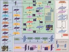
Fig.1
Architecture of DGISM
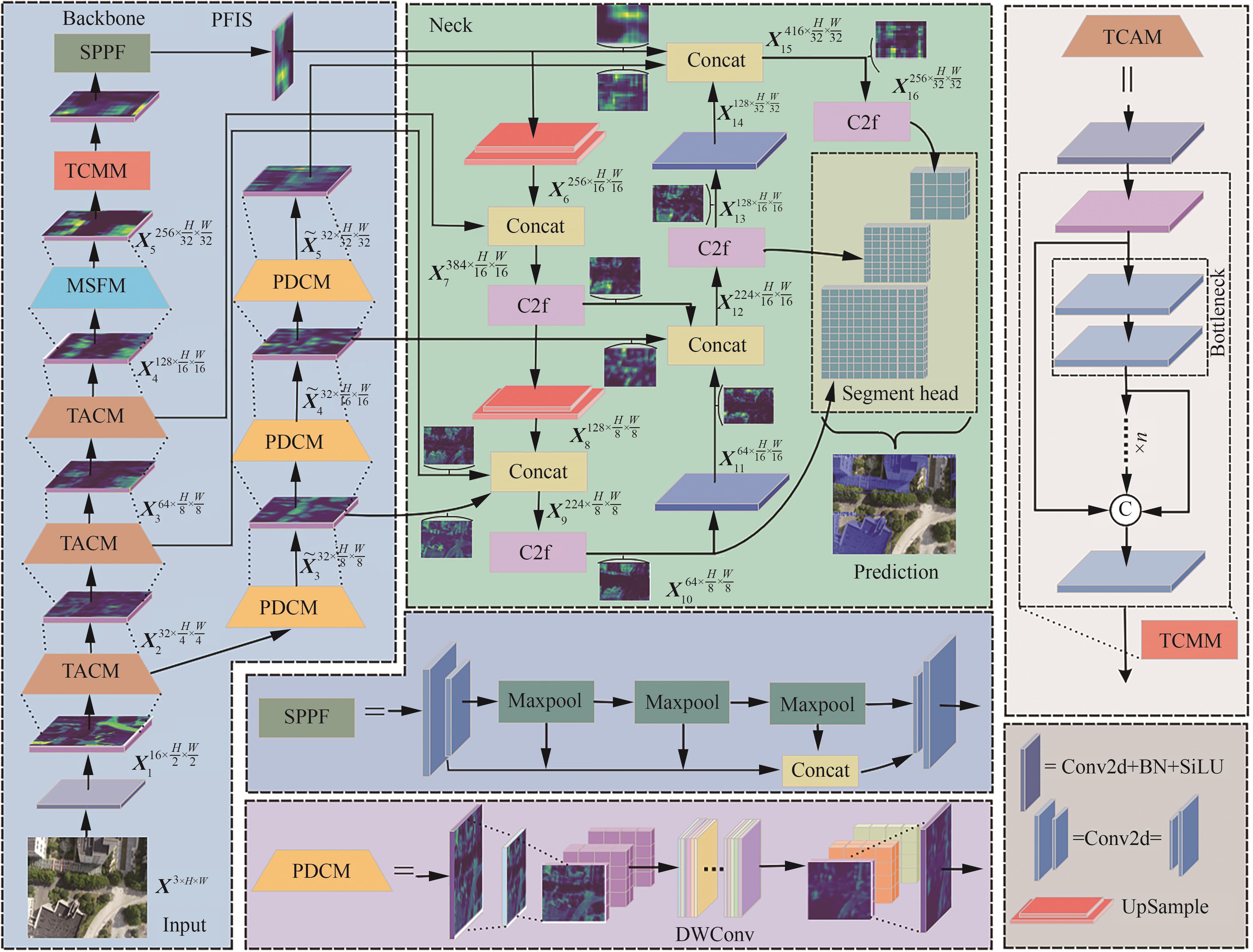
Fig.2
Structure of TACM
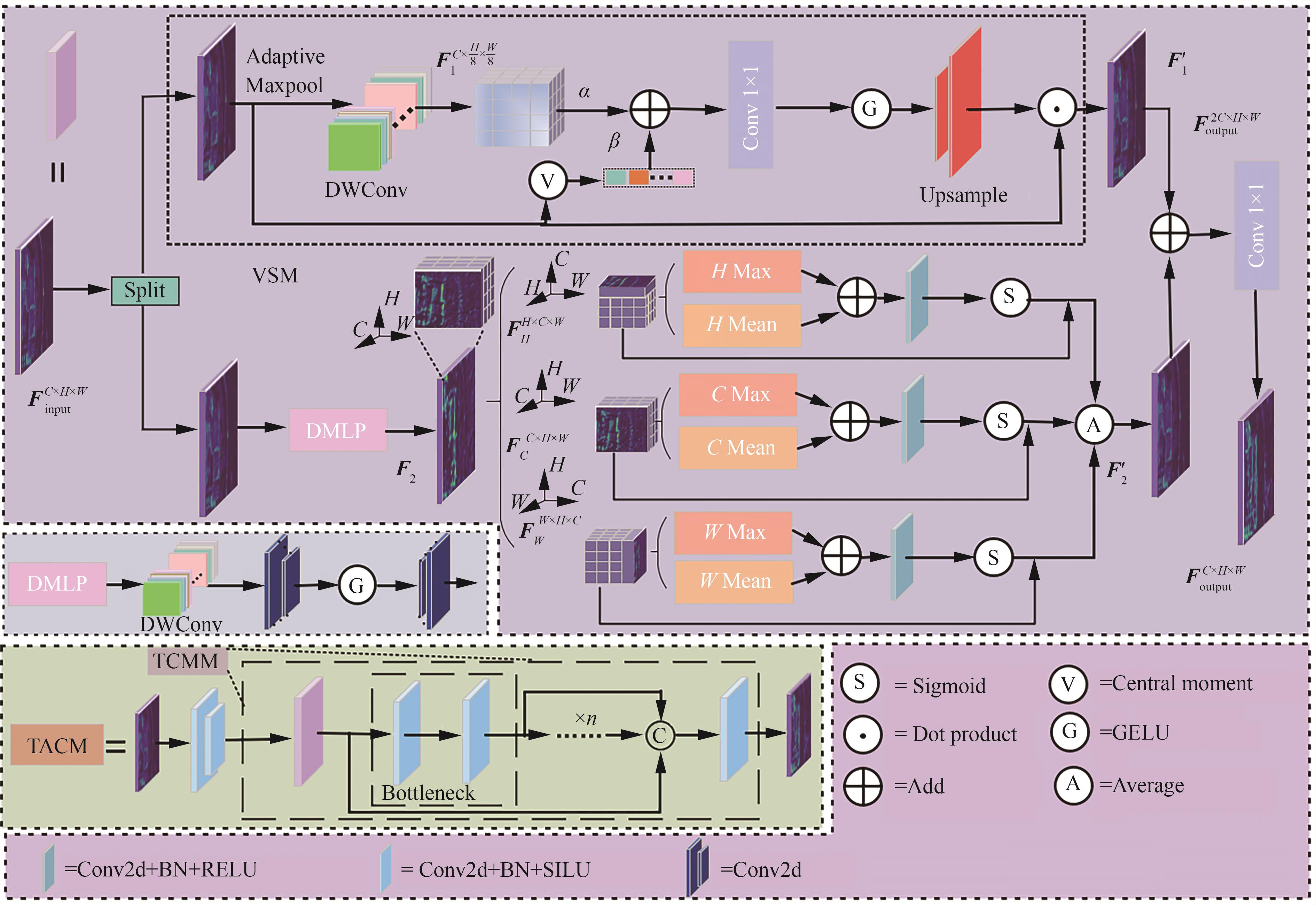
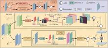
Fig.3
Structure of MSFM
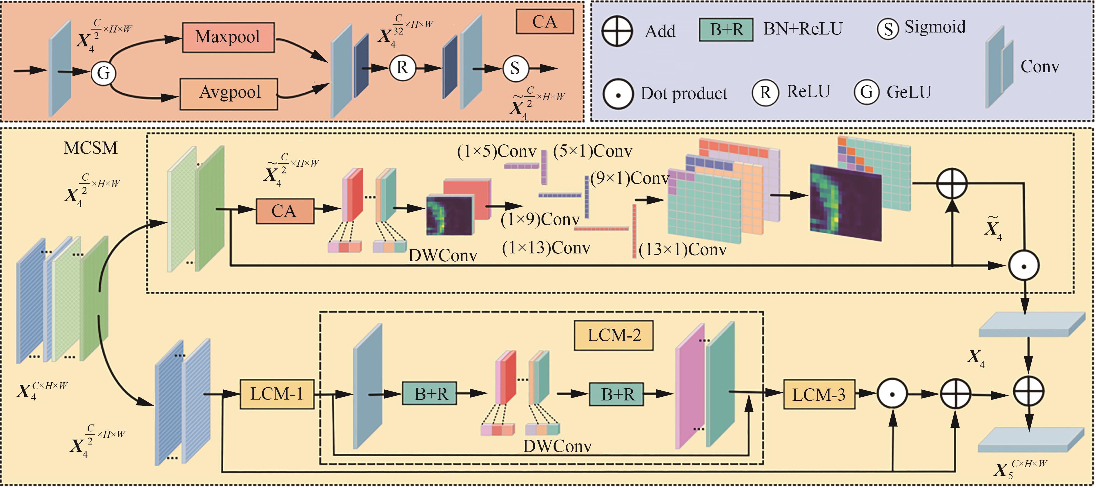
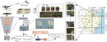
Fig.4
Structure of DPPM
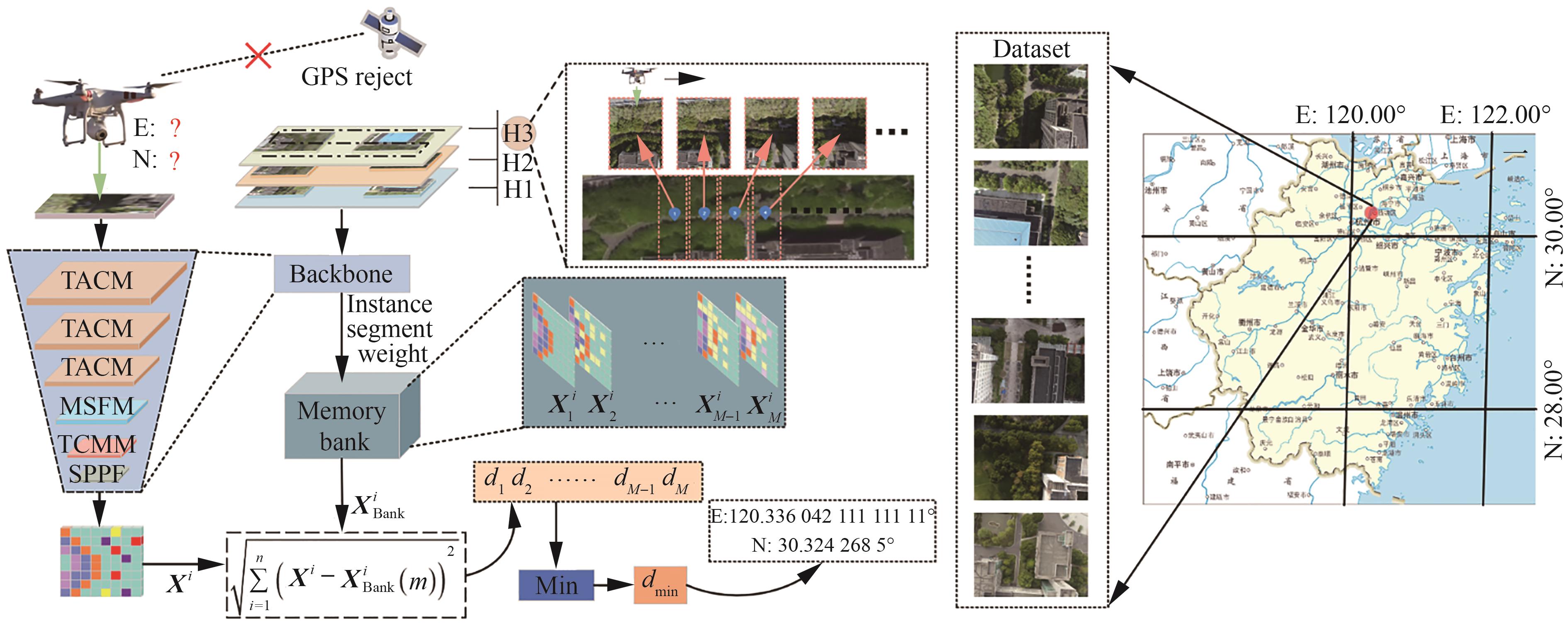
Table 1
Hyperparameter configuration
| 超参数 | 数值 |
|---|---|
| 批大小(Batch size) | 32 |
| 初始学习率(Learn rate) | 0.01 |
| 迭代次数(Epoch) | 300 |
| 优化器 | 随机梯度下降(SGD) |
| Mosic | False |
Table 2
Ablation experiments
| 模型 | PFIS | TACM | MSFM | mAP50/% | mAP50-95/% | GFLOPs | Size/MB | Inference/ms |
|---|---|---|---|---|---|---|---|---|
| Yolov8n-seg | 83.8 | 62.4 | 12.6 | 6.75 | 2.3 | |||
| +PFIS | √ | 85.3 | 65.5 | 12.9 | 6.84 | 2.3 | ||
| +TACM | √ | 86.1 | 66.7 | 14.7 | 8.52 | 2.5 | ||
| +MSFM | √ | 85.0 | 64.6 | 13.3 | 7.99 | 2.1 | ||
| +PFIS, | √ | √ | 86.9 | 68.7 | 14.9 | 8.64 | 2.6 | |
| DGISM | √ | √ | √ | 88.8 | 69.1 | 15.4 | 10.34 | 2.3 |
Table 3
Different convolution ablation experiments
| 卷积模块 | mAP50/% | mAP50-95/% | Infenence/ms |
|---|---|---|---|
| GroupConv | 81.3 | 62.6 | 2.2 |
| AtrousConv | 83.5 | 62.7 | 2.5 |
| TransposedConv | 84.1 | 63.7 | 2.4 |
| AsymConv | 85.5 | 64.8 | 2.3 |
| DWConv | 85.3 | 65.5 | 2.1 |
Table 4
Comparison of different attention
| 注意力 | mAP50/% | mAP50-95/% | GFLOPs | Inference/ms |
|---|---|---|---|---|
| SE | 83.9 | 63.1 | 13.2 | 2.2 |
| scSE | 81.0 | 59.4 | 13.0 | 1.9 |
| GCNet | 80.5 | 60.1 | 12.9 | 2.1 |
| PPA | 85.8 | 66.2 | 19.3 | 4.4 |
| LFE | 86.0 | 67.6 | 14.6 | 3.3 |
| TACM | 86.9 | 68.7 | 14.9 | 2.6 |
Table 5
Comparison of different feature interactions
| 特征 | C+H | C+W | H+W | mAP50/% | mAP50-95/% | Inference/ms |
|---|---|---|---|---|---|---|
| SFIM | √ | 82.4 | 61.8 | 2.6 | ||
| SFIM | √ | 85.9 | 65.9 | 2.3 | ||
| SFIM | √ | 86.2 | 64.8 | 2.8 | ||
| DFIM | √ | √ | 85.8 | 66.8 | 2.6 | |
| DFIM | √ | √ | 85.5 | 68.5 | 2.8 | |
| DFIM | √ | √ | 84.6 | 63.4 | 2.7 | |
| TFIM | √ | √ | √ | 86.9 | 68.7 | 2.6 |
Table 6
Comparison of different backbone networks
| 主干网络 | mAP50/% | mAP50-95/% | GFLOPs | Size/MB | Inference/ms |
|---|---|---|---|---|---|
| Yolov8n-seg | 83.8 | 62.4 | 12.6 | 6.75 | 2.3 |
| Resnet50 | 82.3 | 64.3 | 80.2 | 55.6 | 7.2 |
| EfficientViT | 77.8 | 50.7 | 56.7 | 10.8 | 4.5 |
| SwinTransformer | 73.1 | 50.2 | 449.3 | 60.2 | 12.2 |
| MobileViT | 70.0 | 51.1 | 13.8 | 7.0 | 5.1 |
| FasterNet | 75.9 | 51.8 | 57.9 | 11.3 | 3.3 |
| Yolov8n-seg+TACM,MSFM | 86.6 | 67.2 | 15.2 | 9.75 | 2.5 |
Table 7
Results of comparative experiment of different models
| 模型 | mAP50/% | mAP50-95/% | GFLOPs | Size/MB | Inference/ms |
|---|---|---|---|---|---|
| Yolov5n-seg | 81.2 | 61.3 | 7.1 | 4.12 | 7.5 |
| Yolov5s-seg | 80.4 | 60.3 | 26.4 | 14.8 | 11.0 |
| Yolov8n-seg | 83.8 | 62.4 | 12.6 | 6.75 | 2.3 |
| Yolov8s-seg | 83.9 | 66.0 | 42.8 | 22.8 | 4.4 |
| Yolov8m-seg | 83.0 | 64.4 | 110.5 | 54.9 | 6.3 |
| Yolov9c-seg | 86.3 | 69.0 | 158.5 | 53.7 | 8.5 |
| Yolov11n-seg | 85.6 | 66.8 | 10.5 | 6.39 | 2.0 |
| Yolov11s-seg | 85.4 | 65.3 | 35.7 | 21.4 | 2.9 |
| Yolov12n-seg | 86.1 | 63.8 | 10.4 | 5.87 | 2.2 |
| Yolov12s-seg | 85.4 | 63.5 | 35.4 | 20.4 | 4.7 |
| DGISM | 88.8 | 69.1 | 15.4 | 10.34 | 2.3 |
Table 8
Comparative experiment of different benchmark models
| 模型 | P、T、M | mAP50/% | mAP50-95/% | GFLOPs | Size/MB | Inference/ms |
|---|---|---|---|---|---|---|
| Yolov8n-seg | 83.8 | 62.4 | 12.6 | 6.75 | 2.3 | |
| Yolov8n-seg | √ | 88.8 | 69.1 | 15.4 | 10.34 | 2.3 |
| Yolov11n-seg | 85.6 | 66.8 | 10.5 | 6.39 | 2.0 | |
| Yolov11n-seg | √ | 88.2 | 68.4 | 15.5 | 10.3 | 2.9 |
| Yolov12n-seg | 86.1 | 63.8 | 10.4 | 5.87 | 2.2 | |
| Yolov12n-seg | √ | 85.5 | 65.8 | 14.5 | 9.78 | 3.0 |

Fig.5
Visualization of network segment results
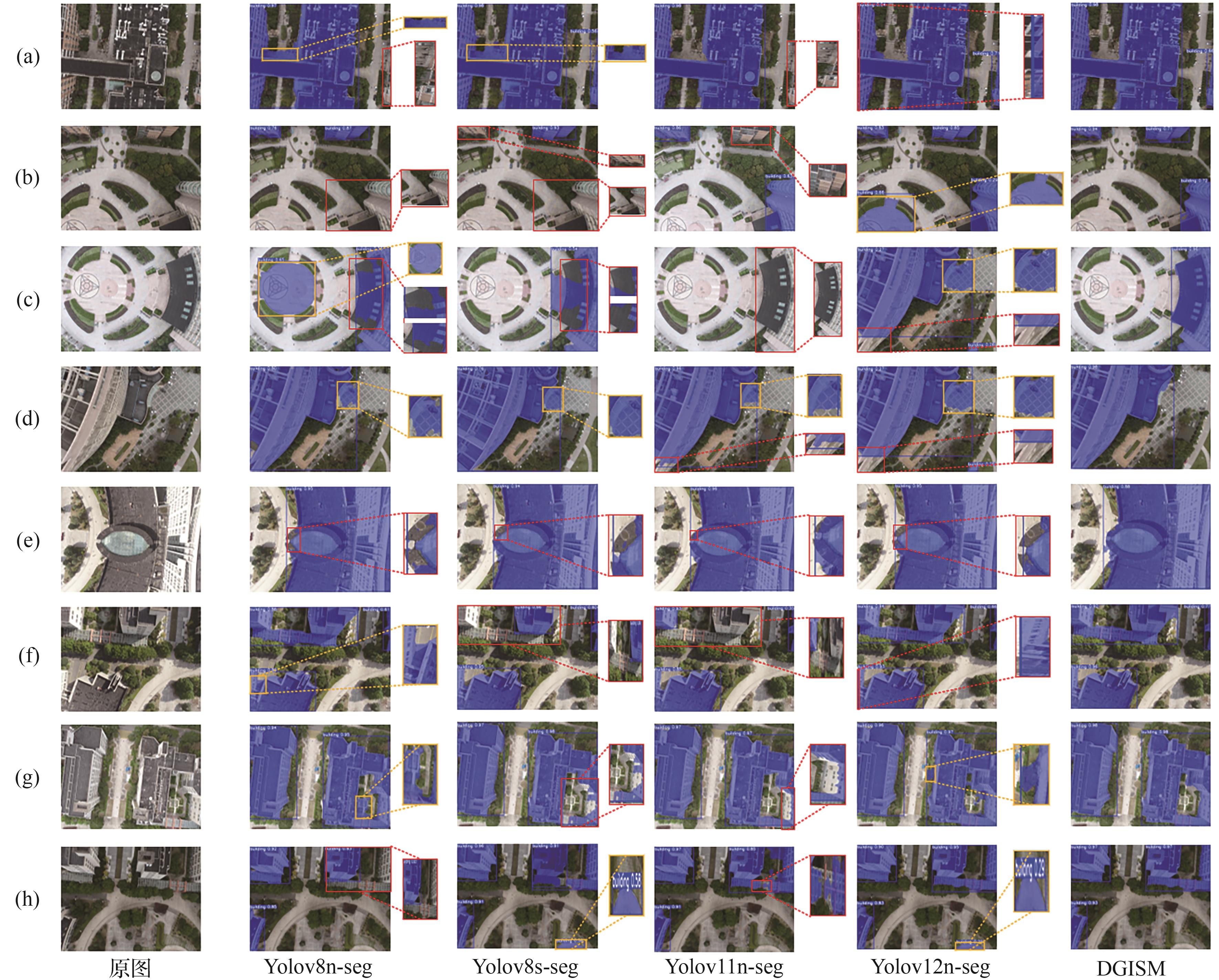

Fig.6
Visualization of network position results
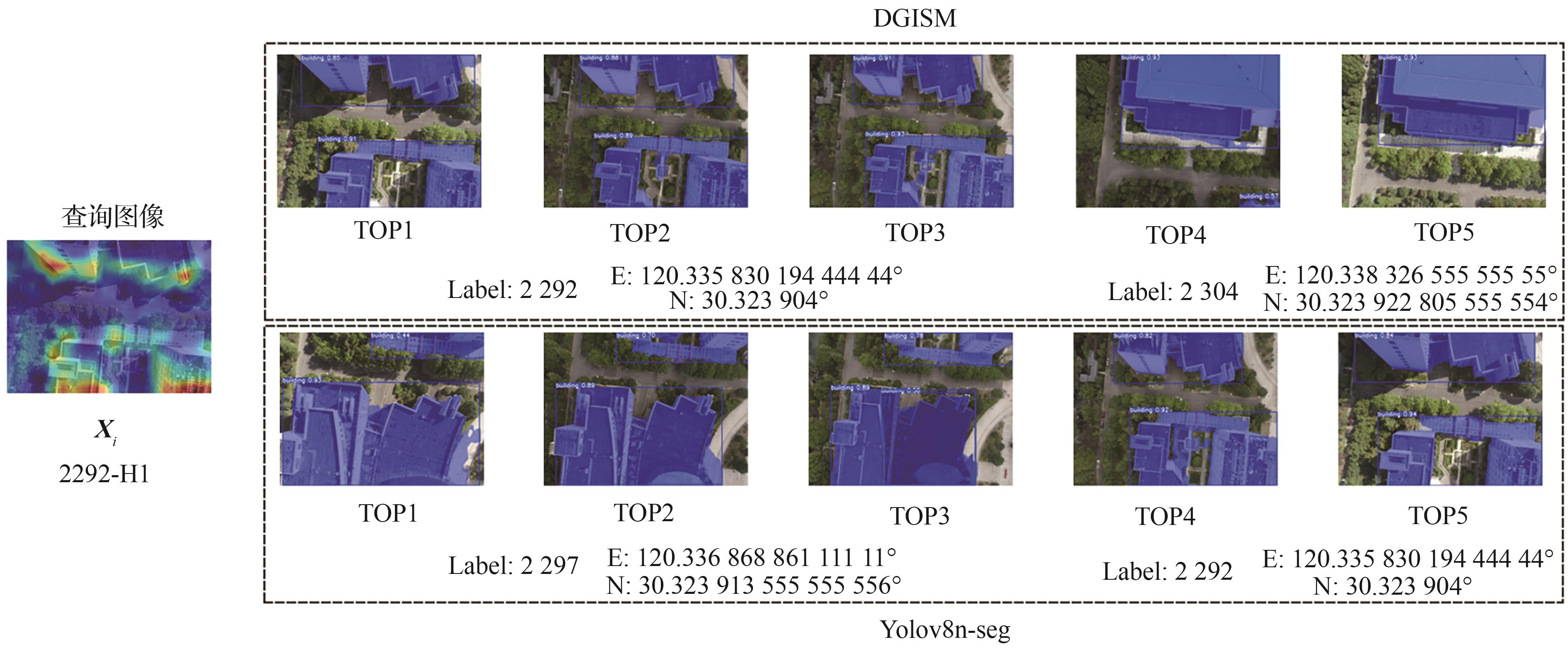
Table 9
Results of experiment of matching positioning
| 2292-H1 | Label | DGISM/10-9 | Label | Yolov8n-seg/10-9 |
|---|---|---|---|---|
| 定位精度 | DGISM 95.6% | Yolov8n-seg 76.1% | ||
| TOP1 | 2292-H1 | 0.235 | 2297-H3 | 2.878 |
| TOP2 | 2292-H2 | 0.235 | 2297-H1 | 2.878 |
| TOP3 | 2292-H3 | 0.235 | 2297-H2 | 2.878 |
| TOP4 | 2304-H3 | 0.311 | 2292-H3 | 2.935 |
| TOP5 | 2304-H1 | 0.311 | 2292-H2 | 2.935 |
| [1] | 屈若锟, 王致远, 刘晔璐, 等 .面向城市空中交通的无人机视觉定位技术研究[J].航空学报, 2025, 46(10): 531168. |
| QU R K, WANG ZY, LIU Y L, et al. Research on UAV visual positioning technology for urban air mobility[J]. Acta Aeronautica et Astronautica Sinica, 2025, 46(10): 531168 (in Chinese) | |
| [2] | HE K, GKIOXARI G, DOLLÁR P, et al. Mask R-CNN[C]∥Proceedings of the IEEE International Conference on Computer Vision. Piscataway: IEEE Press, 2017: 2961-2969. |
| [3] | CHEN K, PANG J, WANG J, et al. Hybrid task cascade for instance segmentation[C]∥Proceedings of the IEEE/CVF Conference on Computer Vision and Pattern Recognition. Piscataway: IEEE Press, 2019: 4974-4983. |
| [4] | CHENG B, MISRA I, SCHWING A G, et al. Masked-attention mask transformer for universal image segmentation[C]∥Proceedings of the IEEE/CVF Conference on Computer Vision and Pattern Recognition. Piscataway: IEEE Press, 2022: 1290-1299. |
| [5] | CHEN X, GIRSHICK R, He K, et al. Tensormask: A foundation for dense object segmentation[C]∥Proceedings of the IEEE/CVF International Conference on Computer vision. Piscataway: IEEE Press, 2019: 2061-2069. |
| [6] | REDMON J, DIVVALA S, GIRSHICK R, et al. You only look once: Unified, real-time object detection[C]∥Proceedings of the IEEE Conference on Computer Vision and Pattern Recognition. Piscataway: IEEE Press, 2016: 779-788. |
| [7] | WANG X, ZHANG R, KONG T, et al. Solov2: Dynamic and fast instance segmentation[J]. Advances in Neural Information Processing Systems, 2020, 33: 17721-17732. |
| [8] | ZHOU C. Yolact++ better real-time instance segmentation[M]. California: University of California, 2020: 1108-1121. |
| [9] | BOLYA D, ZHOU C, XIAO F, et al. Yolact: Real-time instance segmentation[C]∥Proceedings of the IEEE/CVF International Conference on Computer Vision. Piscataway: IEEE Press,2019: 9157-9166. |
| [10] | DONG C, TANG Y, ZHANG L. GHA-Inst: A real-time instance segmentation model utilizing YOLO detection framework[J]. Cluster Computing, 2024, 27(6): 7401-7415. |
| [11] | WANG C Y, BOCHKOVSKIY A, LIAO H Y M. YOLOv7: Trainable bag-of-freebies sets new state-of-the-art for real-time object detectors[C]∥Proceedings of the IEEE/CVF Conference on Computer Vision and Pattern Recognition. Piscataway: IEEE Press, 2023: 7464-7475. |
| [12] | 姚俞成,李旭,徐启敏,等 .基于特征增强和校准的航拍车辆实例分割方法[J].航空学报,2023, 44(24): 328397. |
| YAO Y C, LI X, XU Q M, et al. Instance segmentation for vehicle in UAV aerial images based on feature enhancement and calibration[J]. Acta Aeronautica et Astronautica Sinica, 2023, 44(24): 328397 (in Chinese). | |
| [13] | CHEN Y, YUAN X, WANG J, et al. YOLO-MS: Rethinking multi-scale representation learning for real-time object detection[J]. IEEE Transactions on Pattern Analysis and Machine Intelligence, 2025, 47(6): 4240-4252. |
| [14] | WU H, ZHANG M, HUANG P, et al. CMLFormer: CNN and multi-scale local-context transformer network for remote sensing images semantic segmentation[J]. IEEE Journal of Selected Topics in Applied Earth Observations and Remote Sensing, 2024, 17: 7233-7241. |
| [15] | CHEN N H, LOU T S, ZHAO L Y. MMHCA: Multi-feature representations based on multi-scale hierarchical contextual aggregation for UAV-view geo-localization[J]. Chinese Journal of Aeronautics, 2025,38(6): 103242. |
| [16] | 曹正阳, 张冰, 白屹轩, 等. GNSS/INS/VNS组合定位信息融合的多无人机协同导航方法[J].兵工学报, 2023, 44(S2): 157-166. |
| CAO Z Y, ZHANG B, BAI Y X, et al. GNSS/INS/VNS integrated positioning information fusion method for multi UAV cooperative navigation[J]. Acta Armamentarii, 2023, 44(S2): 157-166 (in Chinese) | |
| [17] | SUN K, MOHTA K, PFROMMER B, et al. Robust stereo visual inertial odometry for fast autonomous flight[J]. IEEE Robotics and Automation Letters, 2018, 3(2): 965-972. |
| [18] | NASSAR A, AMER K, ELHAKIM R, et al. A deep CNN-based framework for enhanced aerial imagery registration with applications to UAV geolocalization[C]∥Proceedings of the IEEE Conference on Computer Vision and Pattern Recognition Workshops. Piscataway: IEEE Press, 2018: 1513-1523. |
| [19] | CHOI J, MYUNG H. BRM localization: UAV localization in GNSS-denied environments based on matching of numerical map and UAV images[C]∥2020 IEEE/RSJ International Conference on Intelligent Robots and Systems (IROS). Piscataway: IEEE Press, 2020: 4537-4544. |
| [20] | Ultralytics. YOLOv8 2023 [EB/OL]. . |
| [21] | 邓立暖,尧新峰. 基于NSST的红外与可见光图像融合算法[J]. 电子学报,2017, 45(12): 2965-2970. |
| DENG L Y, YAO X F, et al [J]. Infrared and visible image fusion algorithm based on NSST. Journal of Electronics, 2017, 45(12): 2965-2970 (in Chinese) | |
| [22] | DAI M, ZHENG E, FENG Z, et al. Vision-based UAV self-positioning in low-altitude urban environments[J]. IEEE Transactions on Image Processing, 2023, 33: 493-508. |
| [23] | HU J, SHEN L, SUN G. Squeeze-and-excitation networks[C]∥Proceedings of the IEEE Conference on Computer Vision and Pattern Recognition. Piscataway: IEEE Press, 2018: 7132-7141. |
| [24] | ROY A G, NAVAB N, WACHINGER C. Concurrent spatial and channel ‘squeeze & excitation’in fully convolutional networks[C]∥Medical Image Computing and Computer Assisted Intervention-MICCAI 2018: 21st International Conference, 2018: 421-429. |
| [25] | CAO Y, XU J, LIN S, et al. Gcnet: Non-local networks meet squeeze-excitation networks and beyond[C]∥Proceedings of the IEEE/CVF International Conference on Computer Vision Workshops. Piscataway: IEEE Press, 2019. |
| [26] | ZHANG P, RAN H, JIA C, et al. A lightweight propagation path aggregating network with neural topic model for rumor detection[J]. Neurocomputing, 2021, 458: 468-477. |
| [27] | ZHANG X, ZENG H, GUO S, et al. Efficient long-range attention network for image super-resolution[C]∥European Conference on Computer Vision. Cham: Springer Nature Switzerland, 2022: 649-667. |
| [28] | HE K, ZHANG X, REN S, et al. Deep residual learning for image recognition[C]∥Proceedings of the IEEE Conference on Computer Vision and Pattern Recognition. Piscataway: IEEE Press, 2016: 770-778. |
| [29] | LIU X, PENG H, ZHENG N, et al. Efficientvit: Memory efficient vision transformer with cascaded group attention[C]∥Proceedings of the IEEE/CVF Conference on Computer Vision and Pattern Recognition. Piscataway: IEEE Press, 2023: 14420-14430. |
| [30] | LIU Z, LIN Y, CAO Y, et al. Swin transformer: Hierarchical vision transformer using shifted windows[C]∥Proceedings of the IEEE/CVF International Conference on Computer Vision. Piscataway: IEEE Press, 2021: 10012-10022. |
| [31] | MEHTA S, RASTEGARI M. Mobilevit: Light-weight, general-purpose, and mobile-friendly vision transformer[DB/OL]. arXiv preprint:2110.02178, 2021. |
| [32] | CHEN J, KAO S, HE H, et al. Run, don’t walk: Chasing higher FLOPS for faster neural networks[C]∥Proceedings of the IEEE/CVF Conference on Computer Vision and Pattern Recognition. Piscataway: IEEE Press, 2023: 12021-12031. |
| [1] | . Distributed Task Allocation Method for Scalable Heterogeneous Swarm [J]. Acta Aeronautica et Astronautica Sinica, 0, (): 1-0. |
| [2] | . Distributed Consensus-Based Cooperative Passive Positioning with Multi-Source Information Fusion [J]. Acta Aeronautica et Astronautica Sinica, 0, (): 1-0. |
| [3] | . An integrated intelligent decision-making algorithm for penetration and strike considering the field of view angle constraint [J]. Acta Aeronautica et Astronautica Sinica, 0, (): 1-0. |
| [4] | . Aerodynamic and flight control characteristics of flying boom based on wind tunnel tests [J]. Acta Aeronautica et Astronautica Sinica, 0, (): 1-0. |
| [5] | . An intelligent modeling method for aircraft formation behaviors integrating LLM technology [J]. Acta Aeronautica et Astronautica Sinica, 0, (): 1-0. |
| [6] | . Enhanced ERG-based Control Framework: Module Design and Experimental Validation [J]. Acta Aeronautica et Astronautica Sinica, 0, (): 1-0. |
| [7] | . Hierarchical fault-tolerant formation control for unmanned helicopters based on the fully actuated system approach [J]. Acta Aeronautica et Astronautica Sinica, 0, (): 1-0. |
| [8] | . Distributed Safety Cooperative Control for Multiple UAVs under Multi-Source Risks [J]. Acta Aeronautica et Astronautica Sinica, 0, (): 1-0. |
| [9] | Jiong HE, Binwu REN, Siliang DU, Yousong XU, Bo WANG. Adaptive attitude control for tilt-quadrotor UAV based on ADRC-RBF [J]. Acta Aeronautica et Astronautica Sinica, 2025, 46(S1): 732189-732189. |
| [10] | Pan ZHOU, Ni LI, Jiangtao HUANG, Qinglin YANG, Yunxiao LIAN. Autonomous decision-making in close-range game under imperfect information for unmanned aerial vehicles [J]. Acta Aeronautica et Astronautica Sinica, 2025, 46(S1): 732215-732215. |
| [11] | Zhihao HE, Peng KOU, Bohua LIANG, Deliang LIANG. Powered yaw predictive control of distributed electric propulsion aircraft considering slipstream effects [J]. Acta Aeronautica et Astronautica Sinica, 2025, 46(S1): 732305-732305. |
| [12] | Chuanjin DAI, Peijie QIN, Lin LI, Bo ZANG. A real-time high-precision frequency estimation algorithm for Starlink signals with CPU+GPU parallel acceleration [J]. Acta Aeronautica et Astronautica Sinica, 2025, 46(24): 332038-332038. |
| [13] | Erchao RONG, Yuying ZHANG, Junning LIANG, Ximin LYU. Neural-network aerodynamics-based NMPC trajectory tracking control for a tail-sitter VTOL UAV [J]. Acta Aeronautica et Astronautica Sinica, 2025, 46(24): 331995-331995. |
| [14] | Guocheng YAN, Honglun WANG, Yanxiang WANG, Yuebin LUN, Junfan ZHU. Prescribed performance anti-swing control for wing rotation process of UAV towed aerial recovery [J]. Acta Aeronautica et Astronautica Sinica, 2025, 46(24): 331840-331840. |
| [15] | Zhao-Xing LI YANG LIN. Finite-Time Deep Stall Recovery Control for Fighter Aircraft Using Forced Oscillation [J]. Acta Aeronautica et Astronautica Sinica, 0, (): 1-0. |
| Viewed | ||||||
|
Full text |
|
|||||
|
Abstract |
|
|||||
Address: No.238, Baiyan Buiding, Beisihuan Zhonglu Road, Haidian District, Beijing, China
Postal code : 100083
E-mail:hkxb@buaa.edu.cn
Total visits: 6658907 Today visits: 1341All copyright © editorial office of Chinese Journal of Aeronautics
All copyright © editorial office of Chinese Journal of Aeronautics
Total visits: 6658907 Today visits: 1341